|
Yellowstone County –
Your Ancestral Past Trail Series
Out
in the Boonies (Trip # 21)
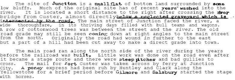
Fort Maginnis – Junction City - 1882
Junction
City - Train Station and Post Office on the NPR 53
miles northeast of Billings and located on the
north bank of the Yellowstone
River, under a high
bluff that protects the town from northern winds in the winter. It is across
from the Big Horn River
outflow. In the summer of 1877 General Sherman established a supply depot
there for the army on the south side of the river. He named it Cantonment
Terry, in honor of General Terry. In June 1877, William Taylor opened a small
trading store at the site of future Junction. His patrons were Crow Indians
and soldiers. It was named Terry’s Landing. When the stage line was
created, it became one of the stops. Until 1880, it was of little importance.
At that time, there were 41 residents resided in the surrounding countryside
called Sage Brush. When NPR passed through, things did not change very much.
It was considered to be a “typical” western town. People there
traded with Fort Maginnis, Fort Custer,
and the local mines. Junction City was platted
and approved by the Custer
County commissioners on
March 8, 1883. Property ownerships for most of the town are located in the
Yellowstone County Courthouse. On
April 5, 1883, a large portion of the business section of the new town was
destroyed by fire, entailing a loss of $10,000. In 1888 the population was
200. Historical
remarks compiled in pdf, 12 pages. Pictures of some of the town can be
found in Paul
McCormick’s bio and related entries.


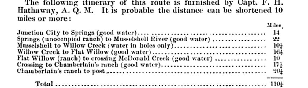
“In 1882, June 24th,
Second Lt LM Brett, 2nd Cavalry, along with one interpreter, one
non-commissioned officer, and four privates from Troop A, 2nd Cavalry,
was ordered to proceed from Fort Maginnis on June 25th to
Terry’s Landing, for the purpose of selecting the best and most direct
route to that point, to be used for supplying Fort Maginnis.” The mileages determined from the journey were:
In retracing his ‘footprint’ as
recorded in the land surveys at or close to that time, I find some minor
discrepancies in the distances, but the route is quite well marked. About 80%
is presently located on private or government land areas. Portions, if not
all, of the route was also used for mail & stage deliveries. The route
from Junction City
northward has a small segment that wasn’t noted on the land survey
records, but the interconnection is quite apparent. There are two trails
departing from Junction City that were used to support this road, and both
depart from the Salsbury Stage line, one to the northwest (Five Mile Creek)
aand to SPRINGS as noted above, and one to the northeast. These trails can be
seen on today’s maps; but in slightly different positions as land
owners started to arrive and the counties took over management of the
surveys. Current highway route 310 mileage between Junction and Musselshell is 31 miles. The GLO land survey records do
not cover all townships for the 1882 time frame.
|
|
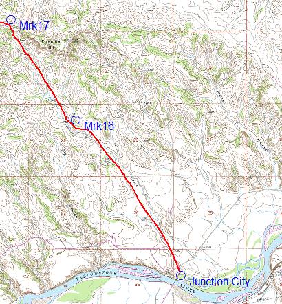
Note: The town of
Junction City
extends between R33E & R34E T5N on the north side of the 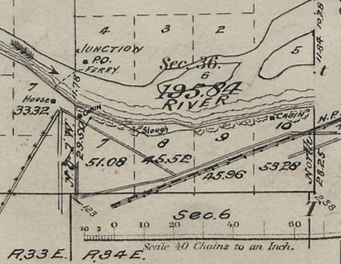
River. The PO will be the starting point for
the trail. Itand the other trail segments will be denoted by a ® symbol.
|
1) The
GLO 1906 land survey plat shows where the Junction City Post Office was
located. This was also the stage stop location. The ‘dashed’ line
on the Yellowstone river depicts where the
local ferry operated. From this location – south – it connected
with Fort Custer,
located on the east side of the Big
Horn River
(Basically across from Hardin). The Signal Corps established heliograph
operations for transmittal of information between many of the military posts
in Montana.
They called upon volunteers for that duty, and extensive training was
conducted using generally a 2”-diameter glass mirror. Messages from Fort Keogh
were transmitted via relay stations between Signal Butte, Maginnis Butte, Junction City and Fort Custer.
The location at Maginnis Butte hosts a square rock cairn, that appears to be
coordinated directionally between Signal Hill (Fort
Keogh) and Junction City. In 1879 the Postal Service
established a mail route from Rock Springs,
WY (junction point with the Union Pacific RR)
connecting with John C Guy’s PO, now
called Eschetah. This route connected with the military forts north of Rock Springs, Fort
Custer, and the
Eschetah, the terminus. This now meant that mail was being delivered in
parallel between Junction City
and Eschetah, a direct violation of the law. Besides that, the mail arriving
at Junction City from the Rock
Springs line was being sorted at that PO, and Junction City wasn’t a legal postal
stop for that line. This and several other fraudulent lines caused the Postmaster
General to be removed from office. The next mail delivery stop on the
Yellowstone Stage line heading east was restricted to Froze to Death Station
(26-miles distant). None of the mail arriving at Junction City from the south was to be
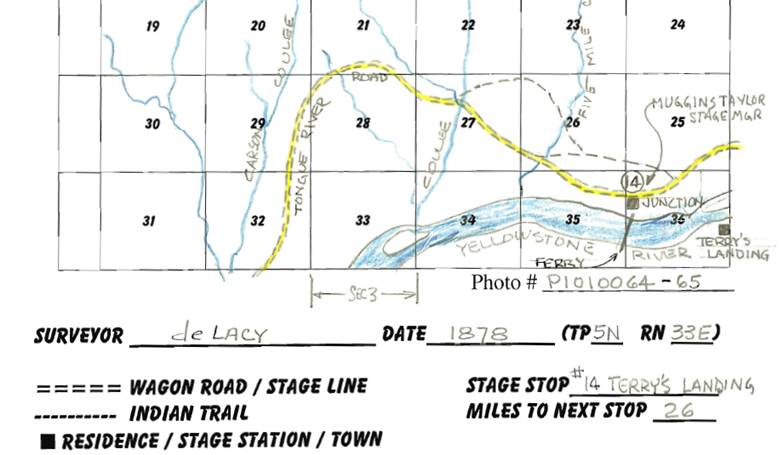
off-loaded or sorted there. The trail to Fort
Maginnis goes north from Junction City through
Sections 26 & 23.
2) 
|