YELLOWSTONE COUNTY, MONTANA

Yellowstone County – Your Ancestral Past Trail Series

Out in the Boonies #6

Pompeys Pillar

By Dave Dodge


Trek to Crockett Water Tower

Monday, January 03, 2005

In the spring of 1899 the CB&Q (Chicago, Burlington & Quincy) Railroad [1] route between Toluca, MT and Cody, WY was surveyed, and in the spring of the following year construction started from the Toluca siding and southward to Cody.  It was completed on 11 November 1901. Soon after the line’s completion, the extensive wagon freighting business between Montana & Wyoming ground to a standstill, and soon vanished. Numerous station stops were created along the line to facilitate the picking up of passengers and freight. In 1911 the line itself vanished. To better understand the region you will be visiting, please refer to the Trails & Tales book by Birdie Streets.

This trek will take you back to the past, and with “just a small amount of imagination,” you can be there when the excitement took place. To reach the site, it is recommended that you approach it from the south. The northern access through the gap might be closed to travelers. Take 310 south to Bridger, and continue on to Warren. Turn east, and immediately take the access road leading north along side of the pipeline. About 14 miles later you will pass by the stone-cement slabs that marked the water tower’s location. It is clearly evident from the roadway. Use BLM Map #36 for reference. There will (or should be) a boundary marker when you cross over into the reservation. At that point you are about 2.2 miles south of the destination.

“When the line was completed, a very large celebration party took place in Cody, with Buffalo Bill Cody picking up the entire tab. It was a time for enjoyment. , Edward Gillette began surveying the one hundred thirty miles of railroad line from Toluca, Montana to Cody, Wyoming. Special permission was obtained from the Crow Indians for the railroad to cross their reservation, a distance of sixty-eight miles. Under the name Big Horn Southern Railroad Company, the line started at Toluca, then proceeded west to Coburn and then south toward the Pryor Mountains in Montana and the Big Horn Basin in Wyoming. Northeast of Pryor Gap, considerable difficulty was experienced in locating a suitable grade. Finally, a fairly steep grade of sixty-six feet per mile was surveyed and built from south of Pryor to the top of the Gap. After leaving the Gap, the road was built down Sage Creek in Montana to present Frannie, Wyoming, then south and west to Cody, Wyoming. Construction of the grade on the northern end of the line began in May 1900. Local people did most of the work. This included a group of Mormons, who had settled in the Big Horn Basin in 1900 and who had just built the Sidon Canal. Under contract with the railroad, these families established their first work camp, consisting of tents, at the crossing of Sage Creek at the top of the Gap in Montana. This Mormon group began work in October 1900. Their contract called for construction of twenty-seven miles of road bed starting at the south end of the tunnel and extending south past present Warren, Montana. The total amount of their contract was $90,000.00. Work was priced on a cubic yard basis at thirteen and one half cents for dirt, twenty-four cents for gravel, thirty-six cents for loose rock and eighty cents for solid rock. Pipe for culverts (which varied in size from fifteen to twenty inches in diameter by twelve feet long) were hauled from the Northern Pacific Railhead at Bridger, Montana along with timbers for bridges. The price was fifty cents per ton a mile.”

“Most of the heavy work was done with horses and mules. Machinery used for moving dirt consisted of: wheeled scrapers, slips, and wagons. Grading machines were used to plow out cuts and level the bed. Drop hammer pile drivers were used to build bridges. Trees from the Pryor Mountains provided thousands of crossties and posts. Camps were established about every five miles on the west end of Big Pryor Mountain where ties were hand-hewn with broad axes. The right-of-way was fenced with four-strand barbed wire.” After the rails were removed, the barbed wire came down.

“Obtaining good water for use in locomotive boilers was sometimes a problem. Soft water was desirable not only for use in their locomotives, but also at stations and sections houses. Much of the available water had a high mineral content and was not only unhealthy for human consumption, but also corroded and clogged the engine’s boilers. Private water rights were purchased on Piney Creek for $20,000.00. Payment was to have been in cash; but as a sign of the times, when offered twenty one thousand dollar bills, the seller refused to accept not wanting all that money on his ranch. The transaction was then handled at Yegen Brothers Bank in Billings. The train made two trips each week, one day from Toluca, Montana to Cody, Wyoming, and the next day a return trip. Before the line was shut down, three trips a week were made. Passengers from Billings, Montana, usually took a stagecoach to Coburn, Montana, to catch the train going south.”

“During its brief existence, few accidents occurred on the Toluca-Cody Line. The only serious accident occurred when a locomotive blew up just below the town of Pryor. The engineer was killed, and much damage was done to several cars and the tender. At nearly any point on the line, it was necessary to lock the brakes on standing freight cars. One runaway car rolled from the flourmill at Pryor to Coburn, Montana, a distance of twenty-five miles, before it was safely stopped. Near Crockett, an accident reportedly occurred when the train brakes failed due to the slickness of the tracks caused by crushed weeds. No one was seriously injured. Sometimes hot cinders from a locomotive caused sporadic fires. Between 1906 and 1908, several such fires were started in the middle of Pryor Gap. Altogether, about ten thousand acres of timber were destroyed. Fire lines can still be seen along the limestone rims of the Gap.”

Mormons built the section between the Pryor Gap tunnel and Scribner. [2] Laborers lived near the section house locations at Pryor, Coburn, Crockett and Frannie. Crockett was located at the south end of Pryor Gap, or as it was called in the 1900’s “Section House Draw.”  A boarding house located there operated from 1905 to 1906 by Charles Reynolds’ wife. Charles was foreman for the crew in this area.

Foundation pilings are all that remain of the structure that used to hold the water tower. It is about ½-mile north of the Pryor Creek – Sage Creek Road junction. These pilings consist of four elongated cemented blocks. Water for the tank came from Sage Creek. There is still some evidence of the old piping along the creek bed. There used to be an old boxcar behind the water tower, where migrants used to stay. The ridge above the water tower used to have numerous “elevated” Indian gravesites.

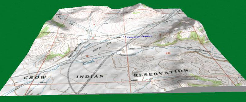
Crockett is located at 45° 14’ 55.53” N & 108°39’ 28.04” W at an altitude of about 5080 feet. The water tank was located about 300 feet to the northwest on the north side of the track. It is alongside the abandoned railroad line grading that is used as a road through Pryor Gap on Crow Indian Reservation land.

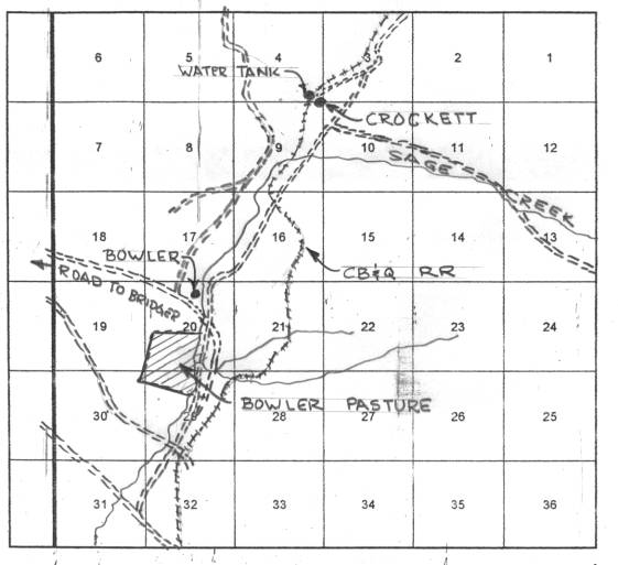
This is a plat of Tp7S R 25E, of the Montana Prime Meridian. Gallagher, who surveyed the area in 1891, initially created the map. Minott, another surveyor, made some additions in 1901. Bowler noted here is the original location for the Stage Station and section house. It was relocated twice to other locations about 4 to 9 miles south in what was called Bowler Flats. The trail leading through the gap is on the old Mee-Tee-Tse [3] Trail. As noted on the topo map above, it is near the summit. These locations are not noted on the BLM or State maps.


[1] The CB&Q was based in Illinois, and another line called the B&M (Burlington & Missouri) was based in Iowa. These two lines merged in July 1880, and the B&M actually constructed this line. However, the CB&Q name stuck with Montanan’s but not persons living in Wyoming who referred to it as the B&M line.

[2] Scribner (called Old Warren) was a stop on the way to Warren. Located there were a water tank, and a section house. Ma. Brown had an over-night place to stay. When Warren itself became an actual section stop, the tank and section house at Scribner were moved to the new location. Scribner had a parallel set of tracks running into the location where freight and wood for the engines were loaded. Also located at Scribner was McFarland’s saloon dug into the hillsides.

[3] Yellowstone Kelly named the trail location as Mee-te-se, currently it is named Meeteetse.


[i] The information presented is primarily extracted from two exceptional sources, unless annotated otherwise: 1) Trails & Tails by Birdie Streets and Monica Weldon, and 2) A General Historical Survey of the Pryor Mountains, by David Harvey, BLM September 1974.


Return to Out in the Boonies Index


  Email me:
Katy Hestand
Yellowstone County Coordinator


© 2014 MTGenWeb