|
|
|
||
|
|
 - -  Out in the Boonies (Trip # 14) |
||
|
Pompeys Pillar |
By Dave Dodge & Cleve Kimmel |
||
|
Trek completed 15 September 2008 4x4 Jeep |
Abandoned
Historical Post Offices in |
||
|
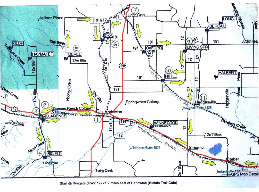
This trek is mostly on gravel roads. It starts at Caution: Please note that the coordinates on these
abandoned towns vary from research to research. But they are somewhere near
by. Two Dot and Harlowton are well located. The coordinates used are from the
USGS site. Please use your GPS to locate the sites, as it will assist in finding
the abandoned locations. |
|||
|
|
|||
|
START |
|
Ryegate (our starting point) is about 63 miles from
|
|
|
Enroute to Harlowton
– Drive by Winnecook |
|
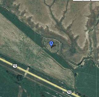
Enroute to Harlowton you will pass through Barber,
Shawmut & Winnecook. Winnecook is now non-existent, and the former
location sits on private land located about 0.2 miles north of the highway.
This Map Coordinates: 46.3999582 N -109.6640697 W (Elevation 4,002 feet) |
|
|
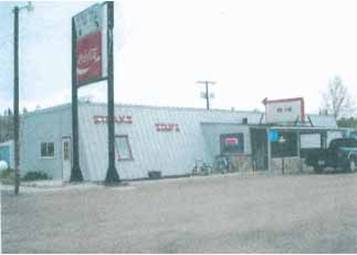
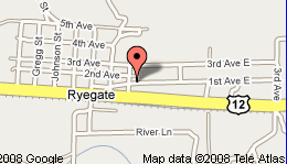
Stop #1 Harlowton 21.2 Miles |
|
Harlowton stop is to “top-off” your gas
tank. Try not to stretch your LUCK! We stopped at Ray’s Conoco on the
north side of the road. A short while ago I was with a fellow driving a new
Chevy Suburban that had all the bells and whistles you can imagine. He stated
that there was plenty of gas, not to worry. While nearing the end of the
trek, one of his new tires, factory standard issue, gave a caution warning
– “Low Pressure – 2-pounds. I got out and looked, and said
“your gage is wrong – it is flat! The spare required a lot of
effort & time to extract from the wheel well under the vehicle. A few
miles further on the courtesy voice and dashboard light, announcing
“low fuel” came active. Asking my friend, somewhat sarcastically,
“what’s that mean?” I guess you were right, I should have
topped off, he said. There was a gas station about 30-miles distant and by
coasting downs all the hills; and fortunately there were more down –
than up, we coasted into the station “bone-dry!” Driving on rough-gravel roads does seem to
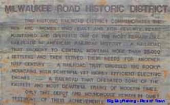
suck up the gas. Harlowton was established June 10, 1900 by Richard Harlow,
who also was considered to be the father of the Montana Railroad (Jawbone
Line.) Incidentally, new & proper steel-belted tires were installed so as
to forego future problems! |
|
|
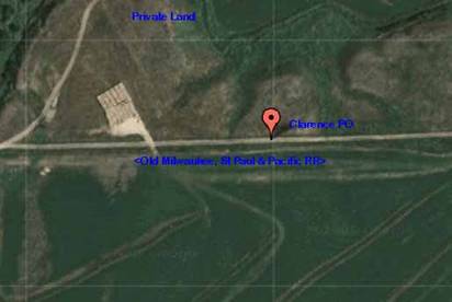
Stop #2 Clarence 43.3 Miles |
|
From Harlowton continue east on highway 12 until
reaching Road 12W88S (Two Dot* Road) at 42.1 miles; turn south on that road
and cross the Location: 46.4218975 N
-109.0590750 W (Elevation:
4,449 feet) * Two Dot still has an active post office, so it
isn’t part of the trek, but take plenty of time to browse this colorful
town & meet the people.. |
|
|
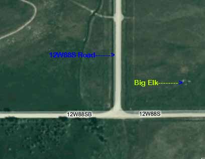
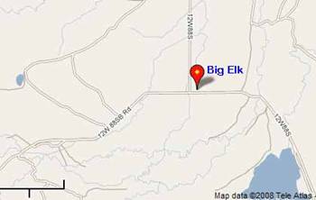
Stop #4 Big Elk 50.0 miles |
|
Continue south on 12W88S until you reach the
intersection with 12W88SB. Turn east, stop and look north. Only pasture land
is seen, all buildings have long gone their merry way. Coordinates: 46.3299540 N
-109.0507410 W (Elevation:
4,882 feet) Big Elk is eight miles upstream from where Big Elk
Creek joins the |
|
|
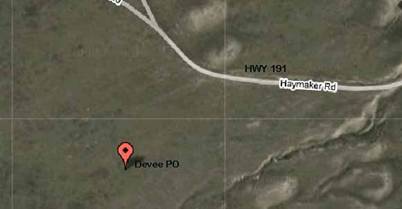
Stop #5 Devee 68.5 miles |
|
From Big Elk return the way you came, and head east
towards Harlowton. You will pass on the return leg (HWY 12) Mexican John Rd
(not through), Historical Point Marker of the Crazy Mountains, Clyde’s
Rd (about 5-miles west of Ray’s Conoco, and finally Lode Rd N. Take Coordinates: 46.5791207 W -109.9751875 N (Elevation: 4,856 feet) |
|
|
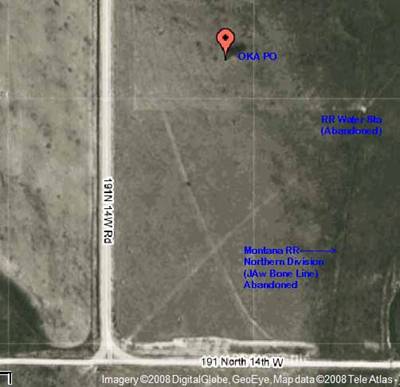
Stop #6 99.9 miles |
|
From Devee site continue north to To continue to Coordinates: 46.6232888 W -109.8396297 N (Elevation: 4,787 feet) The |
|
|
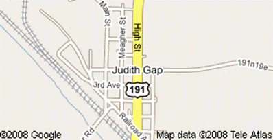
Stop #7 Judith Gap |
|
From Visit web: http://en.wikipedia.org/wiki/Judith_Gap,_Montana#Wind_Power_at_Judith_Gap,
to read about the energy wind farm located nearby. See town & wind farm
pictures at: http://judithgap.net/judith-gap-photos/.
|
|
|
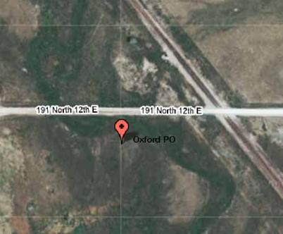
Stop # 8 117 miles |
|
Leave Judith Gap and continue north on High Street ,
turn east on 191 1N 19e (Hwy 297 just a few blocks north of the Mercantile
store) for about 1-1/2 mile, then turn south on Judith Gap Rd following the
RR tracks (the wind farm is located in this general area), and continue
southward until you see the sign “Oxford Rd”, turn south, then
west, and stop at the RR tracks. You are at Coordinates: 46.5916246 W -109.6882376 (Elevation: 4,423 feet) As with the other sites, nothing remains, although
you can roam about looking for clues. |
|
|
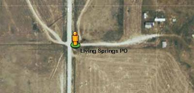
Stop #9 Living
Springs |
|
Depart Oxford, and return to Judith Gap Rd (Hwy
191) and travel east passing Red Fox Rd& Pronghorn Rd on the left,
turning right (south) on Living Springs Rd to the post office (located on
private property.) Use your GPS to locate site. Coordinates:
46.5921830 -109.5362907 (Elevation: 4,649 feet) |
|
|
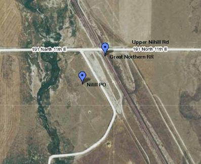
Stop #10 Nihill 135 miles |
|
From Living Springs travel south on 12E116NC (Living Springs
Rd) for 4-miles, passing “ Coordinates: 46.5180144 -109.6176809 (Elevation: 4,226 feet) *Note: Nihill town plat is shown in the Yesteryear’s book, page 352. The 1st closure was reported to be October 31, 1923. |
|
|
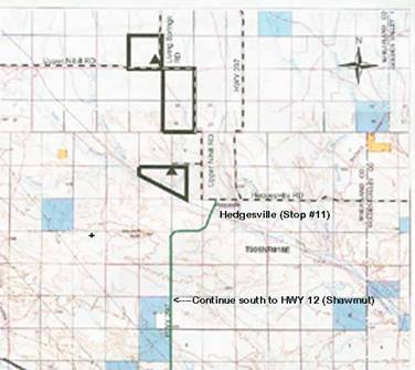
Stop #11 Hedgesville 145 miles End or trip 167 miles at
Ryegate |
|
This isn’t a real stop, and you simply pass through the old town, cross the Burlington Northern RR tracks and go south on road 12E116N (HWY 297) that leads to Shawmut and Hwy 12 for your return trip to Ryegate about 21 miles to the east. This place was named in honor of W.A. Hedges, a pioneer rancher in the vicinity. Hope you had fun and took lots of pictures & met new friends. |
|
|
|
|||