Indian Rock – Billings Montana
Sunday, May 27, 2012
Indian Rock was a naturally occurring piece of sandstone jutting out from
the ground in the northeast section of where Billings was located. From its appearance, it
seems to indicate that it fell from a nearby ledge and buried itself into the
ground. This rock has played an important role in some of the areas most
mysterious history, but unfortunately, it appeared to have had no significance
to the local residents of that era. There are two accounts relating to the
rock’s destruction, both are essentially the same story, excepting for
the difference in dates (1904 vs 1906). This has to
be the same event, since Vermilye blasted the rock
only once, and it had to be 1904. Similar claims about the blasting refer to
making room for a housing tract, but no evidence has been located to verify
that reasoning. In either case, the rock was destroyed.
The first one is that during the planned construction phase for
the Billings Land
and Irrigation Canal this rock had to be removed. In September 1903, ID O’Donnell showed a
Mr. John Schram (a Seattle
financier) around the Billings
area where the ditch’s group planned to place an irrigation canal to
provide water to an area referred to at that time, as “Huntley
Flats.” Mr. Clark then hired an irrigation specialist from Seattle,
Marvin Chase, who started the route investigation in October of that same year. He reviewed the original plans for
irrigation, provided by DeWar in support of the Arid
Land Grant Commission. This map showed the canal routed around the base of the
north rims and passing by Boothill
Cemetery (and Indian
Rock), and onto the plains that were to be irrigated to the north and
northwest. This was at an elevation of about 3200 feet, or perhaps slightly
lower at this junction. Chase determined that a better elevation (3210 feet) could be obtained by locating the ditch nearer to the south
base of the rims and boring a tunnel through the rims itself. Since a new ditch
was required, HP Vermilye (Tacoma,
WA engineer brought to Montana by WT Clark) was
assigned the task of acquiring easement rights for the new ditch (BBWA) that went around the edge of the rims. During
1903 Mr. Vermilye had secured all of the right of
way, with most of it at virtually no cost ($1.00 and consideration –
e.g., land value being worth more with water available than without); some
rights were exchanged for use of the water. In preparation for the
ditch’s route in 1904 he dynamited the rock,
which was in the path of the 1903-planned route. The ditch of course was
actually re-routed to pass through a tunnel the rims, so this action wasn’t necessary.
The second one is that Harold Rixon,
currently a local resident, was informed earlier about
a curious incident that occurred during the first decade of the century, while
he was in college that helped to identify the site and its inscriptive
meanings. At the eastern end of the north rims, where 6th Ave and Highway 10 (Main Street) join
each other, there used to be a landmark called “Indian Rock.” On it
were carved Indian markings describing an “earlier battle that took
place there.” In 1906 Rixon, and a college friend Roscoe F. Allen, learned that a
blasting crew directed by a man named Vermilye was sent to clear the land around the rock. They took their
camera along to record the inscriptions, only to discover that the crew had
blown the rock to pieces just before they arrived! Rixon
claimed that it was a shame that no picture had been taken
of the inscriptions before the blasting.
 The
rock was originally carved on its lower bottom with
some sort of “hieroglyphics”, apparently made by the Montana Tribal
Indians. Little was done in an attempt to decipher the
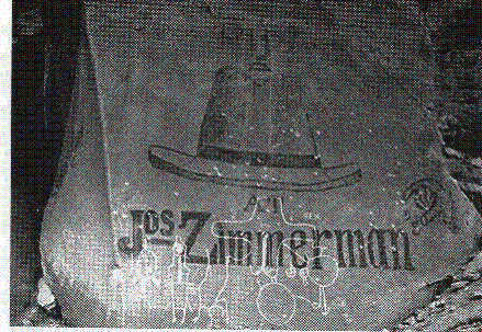
writings. After Billings
was founded Joseph Zimmerman, following in Losekamps
marketing endeavors to use local landscape for advertising,,
painted a sign on the rock. He operated a clothing and
shoe store on Montana Avenue,
near 25th Street,
in the early 1880’s, opening about one year after Losekamp
had his clothing store one block to the west. The Zimmerman store carried a
very large sign over its FRONT saying “BOOTS and SHOES”. Above that
sign was another one, CLOTHING.
The
rock was originally carved on its lower bottom with
some sort of “hieroglyphics”, apparently made by the Montana Tribal
Indians. Little was done in an attempt to decipher the
writings. After Billings
was founded Joseph Zimmerman, following in Losekamps
marketing endeavors to use local landscape for advertising,,
painted a sign on the rock. He operated a clothing and
shoe store on Montana Avenue,
near 25th Street,
in the early 1880’s, opening about one year after Losekamp
had his clothing store one block to the west. The Zimmerman store carried a
very large sign over its FRONT saying “BOOTS and SHOES”. Above that
sign was another one, CLOTHING.
The rock was located between the
southeast base of the rims in Section 27, T1N, Range 26E, between the
Burlington Railroad Spur, at an elevation level of about 3,200 feet. Oh, the
tales this rock could tell! (Photo courtesy Western
Heritage Center)
This rock was located north of the junction where a major Indian Trail
leading to the Big Porcupine hunting grounds on the lower Yellowstone River,
and the small foot trail leading to the Blackfeet Nation near Fort Benton. The
first one was renamed Road to Tongue River (Miles City),
and the other was later named Chief Black Otter Trail in his honor. Arthur
Jesse Hart, printer for the Evening Journal reported on the legend of Chief
Black Otter after having spent some time living with the Crow Indians before he
became a printer. It was this article that inspired
the formal naming of the trail. In the early days it
was very steep, and had severe slopes that tended to tip wagons off on their
sides. Apparently, it took some time to get the road properly graded.
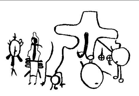
The markings on the rock, copied from the picture have not
been identified or dated. There might be a connection to either the Immel massacre (1823), the trails leading to Big Porcupine
and the Blackfeet Nation, or the mass burial gravesite
at Boot hill Cemetery (c1855).
Behind the rock, in the earth uncovered by the blasting, were the reported
remains of seven white men skulls. No Indian artifacts were located in
the area. The graves were very old. It wasn’t until 1956 that Rixon
and Fred C. Krieg, a person well versed in the early
fur trade, conceived of a possible link to the Immel-Jones
massacre. Fred recalled the ambush, and that it occurred where the valley
narrows, and that Alkali Creek is the only break in the rims for miles, and the
only place fitting the description of the ambush was at this location at the
east end of the rims. He recalled tales of the ambush, and that the survivors,
after the first attack, buried six of their dead before fleeing to the river.
Unfortunately, the seven skulls that were unearthed disappeared, so no further
identification as to their origin could be made. It
was reported that prior to the blasting, the petroglyphs
on the rock had been defaced by a local business establishment (Joseph Zimmerman).
However, he only painted a sign on it, and did not in any way damage the
carvings! There are no other apparent written records of the rock, or
discussions about the discovery of the skulls, or where they
are. Indian Rock was a junction where the overland route joined the Yellowstone River,
and east-west traffic from Buffalo
to Blackfeet, and where Crows and mountain men passed. [The account of the attack was recorded in Hiram Martin Chittden’s “American Fur Trade of the Far
West,” and letters of the attack written by Joshua Pilcher,
fur trapper who succeeded Manuel Lisa at the Missouri Fur Company fort on the
Big Horn River.]
When Walter DeLAcy
conducted the first land section survey in 1878, he passed directly by the rock
when the southern boundary of Section 27 was recorded. He identified the John
R. Harr cabin located north of the boundary line, but
didn’t report anything about the rock. It was as
though he never noticed this boulder with the writing. Earlier, in 1876, when
Col. Gibbon’s force passed through the area on the way to Tongue River, neither he, Lt. Bradley (Chief Guide), and
the Crow Indian Guides never noticed it either. The Crow Guides, upon reaching
this location, paused and paid homage to the sacrifices made earlier (smallpox
epidemic) by picking up a stone, spitting upon it, and placing it onto a
growing pile of rocks that honored the deaths of so many.
Earlier travelers also never reported
anything about the rock. It is as though the engravings were
added after the town of Coulson
and Billings were created. Strange to say the least.
 Email
me:
Email
me:
Katy Hestand
Yellowstone County Coordinator