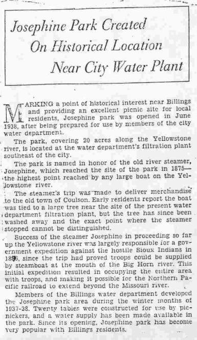
** Josephine River Boat:
The Josephine was a wooden
hulled stern-wheeler packet/snag boat originally owned jointly by John S.
Coulson, Elisa Coulson, Sallie Coulson, James McVay and Fanny Maratta (Coulson
Packet Co.) so as to conserve on the expense of insurance coverage. It was
named for the daughter of General Davis S. Stanley. It normally drew 40 inches
of water [with 4 feet of available cargo space in the hold fully loaded], and
was listed as 300 tons. After it was launched, tickets sold for passengers
carried the identification of the boat as a Sidewheeler [2]. It was empty
when it made its maiden voyage up the Yellowstone River (Records state that it
draw 20-inches of water when empty, two feet with 70 tons loaded, and three
feet with 180.7 tons[3]) by Col. Forsythe. It was 178 feet in length and 31
feet wide. The date for the docking at the Josephine Tree, highest point reached by the Josephine, has
been reported [from peoples memory] in numerous newspaper articles and
biographies as being June 7th, 1877. That statement refers only to
the subsequent docking of the boat prior to the town of Coulson being
formed, and cargo carried to the residents in the local area at the time. The
true first docking of the Josephine near or within Riverfront Park, and its journey
up the Yellowstone from Pompeys Pillar to its final terminus of the journey at
Duck Creek on June 7th 1875 follows. In late May of 1877, Thomas
McGirl reported that the Josephine, carrying cargo he acquired for his store at
Huntley (Baker Ground), and himself as passenger, docked at his place at Baker
Ground.
[When the Josephine
started its first journey up the Yellowstone in 1875 the Cottonwood trees near
the Glendive area were reported to be from 3 to 5 feet in diameter. They
diminished in size upon approaching the Billings area. In the vicinity of where
Coulson would be formed three years later, the trees were small, typically 6 to
10 inches in diameter. When the area known as Josephine Park was reached [Perry
McAdows land], the trees were reported to be from 20 to 26 inches in diameter;
and that size continued upstream at least for about a mile or two. A boat the
size of the Josephine would probably require a large tree to safely anchor it
to the riverbank. After the town was well established (approximately 1879 to
1882) diaries of the local residents, compiled by I. D. ODonnell, recalled
that the Josephine docked near the site where the water plant was eventually
located. This would have been immediately downstream of Ramseys Rapids [Hell
Gate Rapids.](Josephine Park on the south edge of McAdows land) to load and
unload supplies, thus the creation of the Park to honor those occasions. To go
further upstream would have been a complete folly on the Captains part as he
would have had to travers the rapids, and the supplies would have had to have
been transported a long distance back to the town. This location for
transferring supplies and goods to Coulson residents in 1877 has no relation
with the initial military expedition in 1875 that terminated upstream of the
Duck Creek Bridge and its highly probable stopping at Riverfront Park
[Cochrans land] on June 6th, or the later initial trip to town in June 1877
carrying supplies when captained by Grant Marsh. In June 1877, Joseph Cochran reported
that he wasnt home when the boat tied up to his tree, but recalled seeing the
tree and its inscription left by the captain. He regretted not saving the tree.
The Yellowstone Rivers length
is not exactly known but is currently reported to be about 671 miles in length.
The two military commanders and not Captain Marsh recorded the official
distances traveled for this specific military trip. They reported 46 miles to
be the distance from Pompeys Pillar to the end of their journey. Forty-six
miles from Pompeys Pillar places the terminus below the Ditch pick up point
southeast of Laurel at the edge of Yellowstone County (Gallatin County) when it
was first formed. It is presently called Stillwater County.
Thirty years after the 1875
exploration, it was proposed by our government by the residents of Miles City
that a dam should be constructed across the Yellowstone River for improved
water supply to the local area. Captain Grant Marsh, on 21 November 1907, sent
a letter to President Theodore Roosevelt,
requesting that such a dam would be disastrous to the river. The President
listened to him, and the plans were stopped. In that letter he described his
Expansion riverboat experiences, but not the one where he piloted the
Josephine upriver in June of 1875, along with Colonel Forsythe, as denoted
in the theatrical letter.
Caution: There is a duplicated
letter with the same date circulating on the web files for theatrical purposes,
where several conflicts of memory are committed, as compared with the official
government report. Do not use that letter for research. These three memories
are actually part of the June 1875 Yellowstone exploration that immediately followed the trip
described below:
There were some professors from the
Smithsonian Institute with us for the scientific part of our expedition
[These were
assigned on the 2nd trip established in June 1875 by the War
Department.]
Careful measurements are best on an
expedition like this of course, but we had neither the time nor the safety for
careful surveying on shore. What we did was put three men on top, or
hurricane deck, with one at the stern and two at the bow. One at he bow would
pick a point on shore and walk from bow to stern, keeping even with the point
on shore, so he was in place while the boat moved beneath him. When he reached
the stern, the boat had traveled exactly 150 feet. He went back to the bow
while the second man also picked a point and walked to the stern, and the man
in the stern kept track of how our distances from point to point, Inexact
distances I grant you, but still the standard pilots us on the Yellowstone.
[The
Josephines upper deck is calculated to be about 138 feet; the Far Wests deck
was 150 feet, and earlier he had performed that measurement feat using that
steamer. Recording of mileage distances going upriver in 1875 were not
required, as the river and its various streams had been well surveyed, and a
copy of that map was onboard at the time. The 1 Gatling gun, a huge weapon
resembling a howitzer, along with its 10,000 rounds of ammunition took up a lot
of space. The only place it could have been erected was on the upper deck. The
bow, where it would have otherwise been located was full of poles and rigging
for sparing, hay and straw for the horses, plus the four horses were stabled
there.]
[When
stopping on the night] I carved the name Josephine and the date, June 7th, on the cottonwood to which the boat
was tied.
[The steamer
arrived on June 6th, not the 7th. Departure dates arent
used to denote arrival dates. This was the 1877 arrival date.]
Captain Marsh identified in
this letter that when they stopped at Pompeys Pillar, and that he took a second
American flag he was carrying, and planted it at the top. He also admitted to
carving Josephine, June 3, 1875' on its
face. His letter has caused much confusion about the events that took place
during the ensuing years. These minor infractions do in no way demeanor his
heroic achievements. This appears to be the sole source for creation of a
June 7th, 1875 arrival date in Riverfront Park. All other
references appear to have copied this comment as being the arrival date as used
to mark the tree; when the 1875 date has been mentioned.
Please note
that in May 1873, Captain Grant traveled the Yellowstone area down to the Big Horn
River to accommodate the NPR surveyors and the supporting military. He was well
acquainted with the area!
The Josephine Journey
[Extracted
from reports made by Lt. Col. J. W. Forsyth, Lt. Col. F. D. Grant, & Capt.
William Ludlow]
War Department Report Expedition Up the
Yellowstone River June 1875
&
War Department Report Reconnaissance
to
Yellowstone Summer 1875, by Corps of Engineers
Forward
The Josephine
provided round-trip transportation for both expeditions. For the first trip it
was assigned to the army on 19 May 1875; and for the second trip it was
assigned immediately thereafter upon its return to the Missouri River. It
appears that many articles written about the first expedition mistakenly
included references to civilians (biologists, archeologists, & others) who
were un-named and on-board. The following civilian scientists were on the 2ndexpedition
and assigned as special assistants to the Army, without compensation.
Identified were: Edwin Ludlow & W. H. Wood from New York; and George Bird
Grinnell & Edward S. Dana from Yale College. The first trip had only the
boat crew and assigned military personnel.[Note that the Billings Gazette, June
30, 1927 article assumed that the boat first docked on June 7thof
1875 on Cochrans land; site of the Josephine Tree.]
Note: Some of the
River mileage sketches have to be corrected to properly reflect the actual
distances reported. Belle Butte is Sacrifice Cliff, Boat docked on June 6th
¼ mile west (south) of Washington Street Bridge location. The June 7th
journey continuation travelled about seven miles to their stopping point 1-1/2
mile west of Duck Creek. Hell Gate Rapids mentioned in the report ran from
Bitter Creek eastward (north) to the exit from Sacrifice Cliff. Tuesday, May
04, 2004. Refer to River Mileage Comparisons for explanation.
General Orders (Letter of Instruction dated May 19 1875, P.
H. Sheridan, Lt-General)
Steamer
Josephine will be placed at your (Lt. Col. Forsythe) disposal at Bismarck, ND
for examination of the Yellowstone River from its mouth to the Big Horn River
and farther up, if possible. Report on timber, soil, geological formations,
depth of water, and character of rapids. Make your examination as complete
as possible, without any unnecessary detention of the boat, and return from any
point when, in your best judgment, there is not sufficient water, or any other
obstacles to impede your progress.
I decline to
authorize you to allow any person whomsoever to accompany you except Lt-Col
Grant (Aide de Camp), who is part of your expedition,
. officers and troops
forming your escort.
Boat personnel will accompany you. Four mounted scouts are authorized.
Personnel on Board
Both Lt-Colonels
boarded the Josephine at Bismarck, [along with Acting Assistant Surgeon J. A.
McKinney]. Twelve officers and 31 men manned the boat; Captain Marsh, boat
commander, was the only boat person identified in the reports. The Josephine
carried no freight for this trip, although it was permitted to do so up to the
point that it would enter the Yellowstone River. It drew 20 inches of water
when it entered the Yellowstone River. All army personnel were from the Sixth
Infantry. No photographers were on board. Note that there were no professors
from the Smithsonian Institute. They were on the same boat, the following
month.]
Stopping first at Fort
Stevenson they took on Company H with 2nd Lt R. E. Thompson and 2nd
Lt C. L. Gurley commanding 40 men, and a one inch Gatling gun supplied with
10,000 rounds of ammunition. Stopping next at Fort Buford they took on Company
E with Capt. Thomas Britton and 2nd Lt R. I. Jacobs commanding 30
enlisted men; and Company G with 1st Lt W. H. Cornell and 2nd
Lt Thomas G. Townsend commanding 30 enlisted men. One months food rations were
loaded for the army members. Each soldier carried 350 rounds of ammunition, and
the enlisted men were assigned duties to chop wood for the trip.
2ndLt Thomas
G. Townsend provided pen & ink sketches of the country, 2ndLt
Richard. E. Thompson provided the map of the Yellowstone River used for the
journey, and Corporal Thoma prepared pencil views of the trip. [2nd
Lt R. E. Thompson also accompanied the 2nd expedition of the
Josephine.]
Four mounted scouts
were added to support the infantry, no names provided. [In the 2nd
expedition, some of these persons were identified, and their exploits
interchanged in error with the 1st expeditions travels in many
published articles and books.]
Mileage
Records
Col. Forsythe 1
Both Colonels
took on the responsibility of making independent estimations of distances
traveled each day, both going upstream and returning downstream. These
measurements on the river and landmark locations agreed closely with each
other. From the mouth of the Yellowstone River to the Powder River, Col
Forsythe on a previous May 1873 trip reported the distance to be 238 miles.
Measurements used by Col Grant & Col Forsythe for calculating mileage
during this trip placed the distance at 180 miles. From the Powder River to the
terminus of the Josephine, their independent measurements agreed within a
variance of two river miles. Col Forsythe reported 250 miles traveled, Col
Grant reported 248 miles. There was one-mile variance in measurement from
Pompeys [sp] Pillar to the final stopping point near Duck Creek (58 miles
versus 57 miles). [The method of measurement was not discussed, however, on
the 2nd trip the mileages were recorded by use of military survey
equipment at each stop. They probably used established landmarks to determine
where they were geographically, and then they estimated the additional mileage
caused by bends in the river.]
[There was no
indication that for this trip Captain Marsh made any measurements of distances
traveled, although stories created in his letter to President Roosevelt so
stated, were embellished about how he used his crew on the upper deck to
establish the distances traveled on this trip. The Yellowstone River by 1875
was well mapped by survey crews, with over eight separate revisions having been
made by the time this trip took place.] If these measurements were actually
used, then there would not have been two separate measurements by both
Colonels. Captain Grant stated that the upper deck of the Josephine was 150
feet in length. According to the photographs of the ship, this deck could only
have been about 100 to 120 feet long. The Far West, a slightly large boat, had
a vastly different design, and its upper deck was at least 150 feet long.
General Forsythe was on this boat long before the Josephine was in operation,
and this is where the apparent mileage estimations must have been observed.
Captain Grant also stated that he gave his notes of the trip to Col. Forsythe
.It was General Forsythe.
River
Conditions
It would appear that
the river shape is basically the same today as it was in 1875, except for
erosion and loss of trees. The chutes, sandbars and channels are created mainly
from rock and soil, and are un-moving. When the Josephine entered the
Yellowstone, the river was two feet below its high water mark for the season.
Water levels dropped about 1-1/2 inch per day. Cottonwood trees grew to 3-5
feet in diameter along its bank, and there was plenty of driftwood available
for the boats boilers. The enlisted soldiers chopped wood for each next-days
journey after stopping for the night. Throughout the entire journey, no
white men were seen, although it was hoped that there would be some along
the river to assist the crew in getting wood. Soldiers were placed on guard
duty during the nights, spaced about 300 yards out from the boat.
Monday,
June 3rd, 1875
Portions of the river
below Pompeys Pillar, starting about 12 miles distant, were running at 8-9 miles
per hour, maximum speed of the boat, through a 75 - 85 yard wide channel. The
boat forward speed was calculated to be 1/6thmph. Captain Marsh had
to resort to spars and lines to pull the boat along. This place was called: The
Narrows by the crew. Before this section the average width of the river
was 800 yards. Col Grant considered the river easily navigable to Pompeys
Pillar, even with all the sparing the crew had to do. They docked at
Pompeys Pillar at 5:30 pm. This location was reported to be 39 miles from the
Big Horn River inflow, and is the starting point for the location of the total
distance traveled in this summary. Col Forsythe places the mileage at 204; Col
Grant stated it was 203 miles. A sketch of the total trip follows in five
sectional displays of the Yellowstone River.
Captain Marsh, reported
by other un-named sources, stated he placed an American flag from his ship (it
carried two) on the pillars top. Following Clarks example, he reportedly then
carved the landing date into the rock face of the pillar with a chisel,
Josephine June 3, 1875[4].[However, according to Park officials, there is
no evidence that he carved anything into the rock. Only the soldiers from the
Josephine, who carved their names into the northeast face, and a date June 3,
1877, exist. There are reportedly over 3,500 names carved into this side of
the mountain.]
Col Forsythe visited
the site, looked at Clarks signature, and discovered that it was badly
deteriorated. He had a soldier onboard who was a stonemason, and he had him
carefully restore the signature and date by re-carving the information deeper
into the stone. Note that after the NPR decided to restore and protect the
signature, it was in need of another recarving.
Pompeys Pillar is
located about one mile southeast of the docking point. (Reference Mile Marker
203)
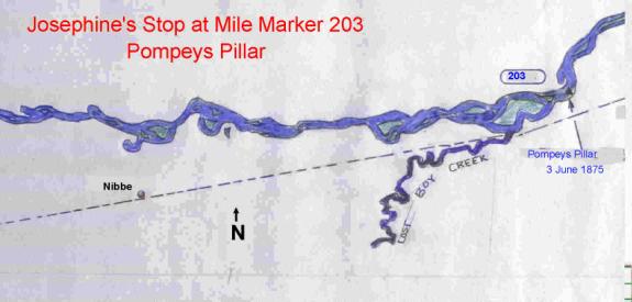
The dashed line represents
the future site of where the Northern Pacific Railway would pass in 1882.
Tuesday,
June 4th, 1875
The group started west at
8:45 am. The water current was very strong, and the crews had to resort to spars
and pulling the boat along for most of the days journey. This was called
Cordelle, and employed a length of rope tied to a tree and a capstan on the
ship, which was turned by a separate Donkey style engine to pull the boat
forward. [Neither file report indicated where they stopped for the night, but a
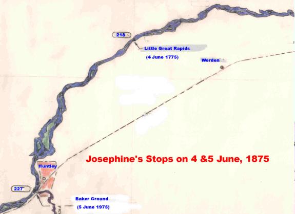
place called Little Great Rapids at mile marker 218, some 15 miles from
Pompeys Pillar is noted and is probably the location. With the headway being
slow, and the current increasing at this point, it was probably as far as they
could go for the day.]
It was stated that the
current increased in velocity as they passed further upstream during the next
two days.
Wednesday,
June 5th, 1875
At mile marker 227 they
reached Baker Ground, a location later named Huntley, and then parts named
Huntley Project. They explored portions of the Pryor River (Creek), which was
25 yards wide at the mouth. They had been passing through portions of land
considered by the Sioux Indians to be their territory, but none were seen. A
sketch of the creeks mouth was made.
Thursday,
June 6th, 1875 (Morning)
The journey continued to
be difficult, with the crews still having to use spars and pulling for part of
the way. Eight miles from the Baker Ground camp they encountered a large group
of Indians at mile marker 234. This is at the entrance to Clarks Fork Bottom,
with the edges of the rims [at the east edge of Billings] on both sides of the
valley become quite evident. This was referred to as Belle Butte.
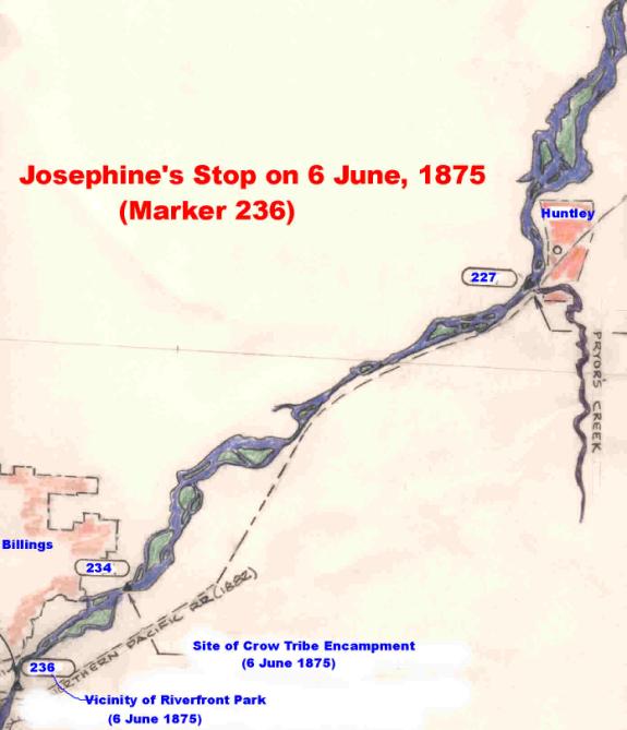
The Crow Indians were
encamped on the north side of the river, on the flat sections of land about two
miles above where the Metra (Fairgrounds) is currently located. They were on
the way to Big Porcupine to hunt. The camp consisted of five tribes and 351
Lodges, approximately 1,800 Indians:
Mountain
Crows 270 Lodges ruled by Iron Bull, Crazy Head, Black Foot, Long Hair and Bear
Wolf
Nez Perce 50 Lodges
ruled by Looking Glass
River
Crows 20 Lodges ruled by Black Bull and Forked Tail
Gros
Ventres of the Prairie 10 Lodges ruled by Brass Bracelet
Bannacks
1 Lodge represented
Many of these Indians were
supplied with Sharps carbines and had 15,000 rounds of ammunition given to
them by the Indian Bureau. Their families were along, and they had many ponies.
The Indians boasted that if they could get a chance at Sitting Bull and his
people not one would tell of the meeting. The Crow Indians further stated
that this Big Horn country belonged to them and if they had to kill all the
Sioux Nation they would do so. [The Crow Reservation at this time ran along
the south border of the Yellowstone River.] The Indian agency was moved
prior to this meeting, from a location near Fort Ellis to the wagon crossing
on the Big Rosebud River.
After leaving the Indian
encampment, they passed through Hell Gate Rapids, two miles further upstream,
which leads into Clarks Fork Bottom. Col Forsythe referred to this section of
river as Hell Roaring Rapids, and is at a point where the Yellowstone-Clarks
Fork Valley begins. JM Hanson[5]described the location of the rapids he called
Hells Roaring Rapids as being just before the boat tied up for the night on
June 6th. This rapid was identified by Captain Grant Marsh as
being at the foot of Belle Butte [Sacrifice Cliff Four Dances Area],
immediately east of Bitter Creek. On the 1878 survey maps, this rapid is
identified as Ramseys Rapids. As Billings grew and the need for water and
electrical power became evident, the Billings Water & Power Company was
formed in 1885. Water was extracted from the Yellowstone River at the beginning
of the rapids, and ducted 4,000 feet around the rapids through a ditch 30 feet
wide and seven feet deep, and passing through the plant before it rejoined the
river. The rapids had a drop of 13 feet[6]. A concrete dam was placed across
the river at this point so as to improve the water flow, and in 1909 it was
abandoned and destroyed[7]. This dam and its destruction eliminated all
evidence of the rapids. According to Lewis Freeman, in Down the Yellowstone,
in 1921, there was no evidence of the rapid anywhere in the vicinity. When the
power dam was constructed, the rapid was wiped out. Water feeding into the
inlet is backed up for quite a distance, suggesting that there was originally
quite a fall. [Note: on the map below, the location is incorrectly
positioned. It should be opposite Perry McAdows land. Correct position in
larger scale follows. This will be corrected later]
Thursday,
June 6th, 1875 (Afternoon)
The boat continued
upstream until they tied up for the night on the north bank of the river. They
attached a line so as to continue Cordelling when they started out in the
morning, since the water was flowing swiftly, and they needed to be pulled
along.
The exact placement of the
Josephine for the night was not specifically mentioned. Col Forsythe simply
stated that they fastened up for the night above Hell Roaring Rapids. [The
location at Riverfront Park would be ideal for docking, since the water at the
north bank is fairly deep, affords good anchorage, and allows for cordelling.
According to Cochrans statement that the boat tied onto a tree on his land,
which was later taken from him for schools, has some merit. The land denoted as
Section 16, in red was confiscated by the BLM in Washington D. C. By
congressional action, and given to the Montana School District. The exact
location is actually of little relative purpose, since it merely identifies
where the boat docked for the night, and does not reflect where the journey
ended. Cochran and the other settlers were not in this area at the time the
boat passed through. It is also very doubtful that Captain Marsh would have
been allowed to dock the boat in the vicinity of Josephine Park, since it would
have been within easy reach and visibility of the Indians encamped about two
miles to the north.] When encamped for the night, Col Forsythe stationed army
personnel some 300 yards from the boat to guard against intruders.
The stopping for the night
was apparently no different from the previous night dockings, and they didnt
realize that their journey would cease the next day. The town of Coulson was
located on land sections later belonging to John Shock (Schock), John Alderson,
and Perry McAdow. When Perry arrived, he started a sawmill business, and opened
a store. The site for Josephine Park was created out of Perry McAdows land.
The following article, published in the Billings Gazette about 1939, source
unknown (believed to be written by Jennie McFarlain, wife of Gazette
publisher), contains misinformation about the Josephines initial journey,
leading to the belief that Josephine Park was the terminus of that journey, and
that the famed Josephine Tree commemorated the event.
Many biographies of early
Coulson residents state essentially the same thing, the Josephine was
bringing supplies to the town, tied up to an old tree near the old filtration plant
(Josephine Park), and was as far as any boat traveled up the river. This
created the long-standing myth that the terminus of the journey in 1875 was at
the Billings location, whether at Josephine Park or Riverfront Park. It is
quite evident that there were two separate events occurring, and that these
became one in peoples minds. Since there was no town, or white people in the
area in 1875, it was not possible for the residents to recall that specific
event. What they probably recalled was the first subsequent docking of a loaded
Josephine, and its tying to a tree at that time. Then it would have tied up to
large tree near the settlement. The trees start to become large [20-26 inches
in diameter] at the Josephine Park area.
The next days journey
on June 7th establishes the basis for the two events becoming one,
and the creation of the Josephine Tree legend. Since McAdow originally had a
sawmill on his property in 1877, it seems very probable that the boat tied up on
the land near his place when it arrived at Coulson that year. The river channel
at the south end of his property is where Hell Gate Rapids starts. The rapid
continues into the sharp bend of the river. To pass through this section and
deliver supplies to the town would be senseless, as it would require much
exertion on the part of the crew; and they would have had to backtrack to get
supplies to the town, and to acquire wood from the sawmill. When the water
plant constructed its plant, they chose the site adjacent to Josephine Park,
since this is where the river took a sharp drop in elevation, and created the
rapids. After the inlet flue was established for the plant, the course of the
Yellowstone River was shifted about 1/8th mile to the west
downstream of the flue. The water flow was greatly reduced, causing the river
to widen, and a large rock-sandbar island was created in that area. By 1921 all
evidence of the rapids has disappeared.
Later in 1878, the
sawmill was relocated onto the southeast corner of John Alderson land at his
request, thus placing it in the new town of Coulson. However, the census
records for 1880 didnt report McAdows sawmill operation personnel (10 people)
as being in Coulson. They were apparently omitted from the census.
Friday,
June 7th, 1875
The boat,
already prepared for the days journey, started upriver. The mounted scouts
were out ahead, evaluating the river terrain. The boat continued forward until
2:10 pm when based on information provided back to Col. Forsythe by the scouts,
it was decided by him to terminate the travel (Per his Letter of Instructions)
and return immediately to Bismarck as the river was too dangerous for them to
continue upstream. The scouts reported that the river ahead of them
for
several miles was unchanged in volu 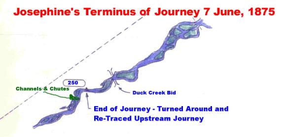 me, it was cut up into various chutes and
channels, by islands, and the river bed so wide, with a most powerful current
hurling it forward to its mouth, that any further progress up the stream could
only be accomplished by sparring and warping, and without any reward for labor
expended. At this point the prow of the boat was turned around, and they
retraced their steps of the previous day. The area just up steam of where the
Duck Creek empties into the Yellowstone provides a suitable spot for a boat of
the Josephines size to easily turn around.
me, it was cut up into various chutes and
channels, by islands, and the river bed so wide, with a most powerful current
hurling it forward to its mouth, that any further progress up the stream could
only be accomplished by sparring and warping, and without any reward for labor
expended. At this point the prow of the boat was turned around, and they
retraced their steps of the previous day. The area just up steam of where the
Duck Creek empties into the Yellowstone provides a suitable spot for a boat of
the Josephines size to easily turn around.
Careful examination of the
river at Duck Creek (which is north of the Big Ditch pickup point in Section
36, also taken over for School Land) shows numerous chutes and channels; many more
than were located further downstream. Col Forsythe did not indicate any
stopping points on their way back, merely that they retraced their steps.
[After spending most of the day fighting strong currents, and turning the boat
around, they probably re-tied to the same place at Riverfront Park and loaded
on a supply of wood for the journey back, although they could have tied up
anywhere further downstream, but due to the time element, they might have had
to camp in the vicinity of the Indian camp.] There is no indication that
Captain Marsh carved the June 7th date into a tree at this time in 1875, there
being no specific reason to do so, as this was not the end of their journey,
although in his letter to President Roosevelt he so stated. Records from JM Hanson
also state that he did so on this trip. That would mean that the boat docked
for the second time at the same place, and then he carved the note. After
turning around no mention of where they stopped for the night was indicated. It
probably was at Pompeys Pillar, or nearby. They took four days to return to
Bismarck.
This enlarged view
shows the mileage locations made by Col. Forsythe and Col. Grant. Belles Butte
is now called Sacrifice Cliff (South Rims.) Hell Roaring Rapids [mile marker
237] was later called Ramseys Rapids. After the Power Plant was constructed in 1887, the water diversion
changed the rivers course, widened the stream flow and the rapids vanished. In
addition, the numerous islands now evident were created, probably as a direct
result of this construction effort. A full dam was created at the site, and
lasted for about two decades. When the boat docked for the night of June 6th,
its location was not reported. Col Grant, continued in his report stating that
on June 7th:We proceeded up the river until the afternoon of June
7, when we found the river so cut up with islands, and all the chutes having
rapids, that it was practically the head of navigation, and decided to return,
as the object of the expedition had been accomplished. The distance of the
highest point reached from the mouth of Powder River we estimated as two
hundred and forty-eight miles.
Mileage
Comparisons:
|
Location
|
Col. Grant
|
Col. Forsythe
|
|
Pryor Creek Convergence
|
226
|
227
|
|
Mountain Crow Camp Meeting
(Before entrance into Clarks Fork Valley)
|
234
|
235
|
|
Hell Gates Rapids Belle
Buttes
(Ramseys Rapids, Hell Roaring Rapids)
[Belle Buttes is Sacrifice Cliff]
|
236
|
Not recorded
|
|
June 6th Docking Point -
This docking location according to ID ODonnell
was ½ mile west of the Old South Bridge [Washington Street Bridge]
(Tied
to two trees, one to keep from drifting, one to enable cordelling on the 7th.
River flow max speed of boat.)
|
[According to the
statements, they docked across from Belle Buttes, after passing through the
rapids.]
|
Boat fastened
up for the night above Hell Roaring Rapids, and a line stretched to
help us forward in the morning. [The rapids started near Bitter Creek, and
continued to the rivers exit at Sacrifice Cliff. Inlet raceway for original
powerplant had its pickup point about ¾ mile above the beginning of the
rapids. This places the June 6th docking point about one mile west
of Josephine Park, e.g., slightly upstream of the Washington Street Bridge,
and opposite of Sacrifice Cliff.]
|
|
End of Journey
June 7th @ 2:10 pm
Travel
distance was about 7 miles.
|
248
We proceeded up the river
until the afternoon of June 7th.
Encountered various chutes
and channels at this point. River force increasing.
|
250
Steamed
upriver from early morning until 2:10 pm, decided to terminate journey. Volume
of water unchanged and so cut up in chutes and channels
further
travel would be waste of labor.
|
|
Journey
Ended near Duck Creek
|
Mileages place end at
Duck Creek
|
Mileages place
end at Duck Creek
|
ID ODonnell, in a talk
given to the Kiwanis Club in 1930[8] stated that Josephine tied up for the
night on June 6th, 1875, one mile upstream of Hell Roaring Rapids,
across from Belle Butte, [meaning the start of the rapids prior to construction
of the power plant in 1887]. This docking location he stated was ½ mile west of
the South Bridge [Washington Street Bridge]. This location agrees in general
with Col Forsythes diary; and places the boats anchoring about one mile from
the east edge of Cochrans Land where the June 7th 1877 anchoring
was reported as having occurred. It was reported by ODonnell that the
exploration party carved into the Cottonwood tree the date of their arrival.
It was decided by the club members to construct a marker for the location of
the tree [which has for a long time been washed away] and the boats docking so
that the location and memory of the event wouldnt be lost. The group
identified the site and location in their publication for tourists called the
Golden Guide. [Note that this site was not the terminus of the Military
journey, and the boat continued upstream during the next day.]
Josephines
Stop on June 7th, 1877 at Coulson (Second Trip to the local area)
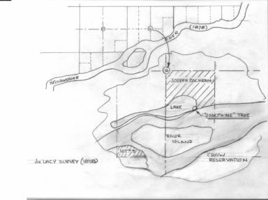
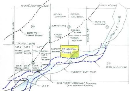
The map in the center
depicts the area of Riverfront Park as surveyed by de Lacy in 1878. The piece
of land belonging to Cochran is enlarged to show the river and lake boundaries.
Currently the lake rests entirely within the former Cochran property, and the
Yellowstone River cuts south just below his property. The large island has been
reduced in size and changed into three chutes. The distance between the river
and the lake was at its narrowest point on the southeast end as indicated by
the marker shown. James Minnie, surveyor hired to locate the place where the
tree once stood re-identified the location. The picture on the right
shows how the river has changed its course since 1877.[Walter deLacy added a
note to his research stating that this was the highest point of navigation on
the Yellowstone. That statement was true only for the 1877 trip into the area,
as he stated in his other field notes.] The land and river areas in this
section have changed drastically from the original survey to current ones. It
would appear from review of land records that the tree site location is still
essentially as shown. Also note that the Josephines upper deck does extend
slightly beyond the smokestacks, making the approximate length about 130 to 140
feet. The picture on the left came from NARA files.
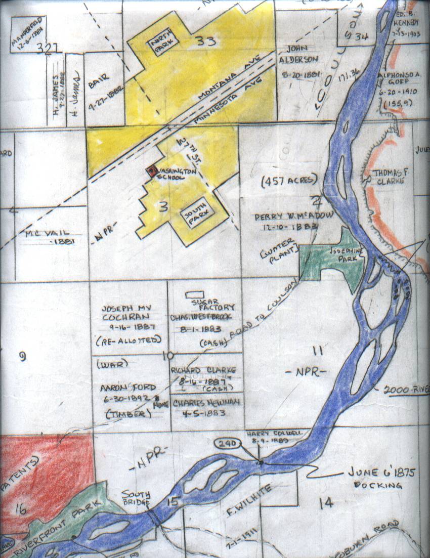
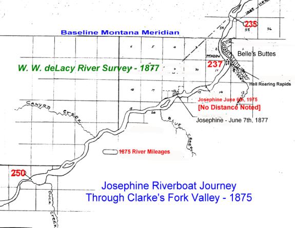
De Lacy Survey Notes 1S,
R26E, FRACTIONAL S16: (October 21 1878, page 49)
.. S61 ½ W 7.70 cross
Cochrans fence. Over S. thence S. 54 ¾ W 9.70 chs lks 6.60 dis (chains, links
and distance). Tree marked by steamer Josephine bears N 50 lks
distant, the highest point ascended to by steamboats. Cochrans house lies
north of tree 4.00 chs. Leave timber at end of course [lks = links, dis =
distance, chs = chains]
De Lacy Survey Map
Accompanying the Survey Notes: (Original Entry dated Oct 18th22nd,
1878)
Tree location noted:
Highest point reached by Steamboat 1877. The trees location was plotted
on Cochrans parcel, Lot #2. Location is about ½ mile west of where the Old
South Bridge on Washington Street was located, directly on the sharp bend in
the river just before Blinkeys Island.
De Lacy Survey Notes 1S,
R26E, FRACTIONAL S16: (October 21 1878, pages 56 -57)
General Description.
This fractional township is situated at the Eastern end of the Clarkes Fork
Bottom. It is bounded on the South and East by the Yellowstone River which has
been navigated by a steamer in 1877 to a point within this township and
a little above the town of Coulson. The land is partly bench and partly bottom
land, all of which is 1st rate land, on which have been grown
vegetables of all kinds. There are several settlers in the township who have
operating farms. The only timber in the township is Cottonwoods along the banks
of the River and on the island mentioned. [Blinkeys Island]
Comment: After the Coulson trading post was
created the Josephine carried supplies to the residents for several years, and
tied up to large trees nearby. A photograph of the event was taken, presumably
when the photographic shop in Coulson opened (Forum files, undated picture),
and Captain Marsh was reported to have carved the date of his docking into the
tree [symbolic memory] for his second trip in the area prior his departure of
the region at that time. He couldnt have done this earlier, since there were
no photographs taken during his first trip up the Yellowstone River, and there
really was no reason to identify a simple docking; the tie-up was not the end
of the journey. This first trip of the Josephine into Coulson after it
was formed probably accounts for the recollection of so many residents
recalling the docking, the carving and the carrying of supplies to the town.
The Josephines first trip was made without any cargo. There are many erroneously
published accounts of the original landing date, some state June 7th,
1877, others June 7th, 1875. The first date is the real one,
signifying the time the boat came to Coulson, loaded with cargo. It is doubtful
that Captain Marsh wrote a separate and detailed report about his second
military excursion into the Yellowstone River, since this trip was strictly a
military expedition of which he had no input in support of possible war with
the Indian Nations, specifically the Sioux. He did however; write a summary
report about river travels to President Roosevelt in 1907, reflecting back on
his vast experiences referring to his 1873 trip with General Forsythe. These
experiences became confusing as the 1873 trip was with General Forsythe, the
1875 trip was with Colonel Forsythe and are what has caused the
misunderstanding as to where and what was carved into the tree, and why the
location became known as the highest point of navigation in error!
Reality
Check of the Tree and Multiple Dates Regarding Josephines Journey into the
Local Area
Captain Grant Marsh stated in
his 1907 letter to President Roosevelt that he carved the boats name
[Josephine] and the arrival date into the area as June 7, 1875. He also stated
that he was forced to give up his notes to Col. Forsythe for military usage.
Reality Check: He actually arrived on site June 6th,
not the seventh. If he carved the 7th into the tree, then he used
the departure date, not the arrivals date. It is more probable that he did the
carving on June 7th, 1877, which would agree with the factual report
provided by Walter deLacy in his 1878 report where the 1877 date was
established. Loss of his notes might have caused some confusion between the two
major trips. There was no mention of any special considerations by the 1875
commanders, Forsythe and Grant that they attributed any special significance to
the June 6th docking, as they were unawares that this was to be
their last shore stop on the river.
I.D. ODonnell in his
research for the Kiwanis Clubs Visitors Guide in 1930, and the establishment
of a permanent visitors marker at the Cochran site, stated that the boat
arrived on June 6th, and that that date was used on the marker and
guide. He also specified that this stop represented the terminus of the boats
journey up the Yellowstone River on June 7th, 1875, indicating that
the sign and guide carried a June 7thdate. (This guide hasnt yet
been located.)
Reality Check: ODonnell has the arrival date correct,
but since the tree had long since vanished, the date was not recorded
elsewhere, but apparently just remembered. He referred to the opening remarks
of Col. Forsythe as meaning to be that the boat stopped at the tree and didnt
continue upstream on the seventh, but simply turned around. This was the same
statement made by Captain Marsh in his 1907 letter. Both individuals forgot to
read the actual journal entries that showed the boat to continue upstream until
they reached the many islands and chutes that would cause them problems. The
survey maps of 1878 show the river to be essentially clear of these cut-up
islands until they reach the Duck Creek area. It is there that the boat was
ordered by Col. Forsythe to turn around and head back as quickly as possible. The
current riverbed is badly distorted and widened in the area of the Cochran
ranch. There appears to be no real need to re-stop at the tree on Cochrans
land just to carve the arrival date, and they certainly must have had
sufficient fuel to reach Huntley or Pompeys Pillar area for the night.
Residents of Coulson recall
that the boat used to tie up near where Josephine Park is now located.
Reality Check: This certainly makes perfect sense. With
the town being created and established across from Sacrifice Cliff, why should
the boat try to go further away from the town, and fight Ramseys Rapids (Hell
Gate Rapids), which had a 13 foot elevation gain in just a few thousand feet?
It would also be able to acquire substantial amounts of fuel from the McAdow
sawmill. In the area downstream of the park, the Cottonwood trees were reported
in 1878 to be small 6 10 inches in diameter. The larger trees appeared on the
McAdow site (Josephine Park.)
Walter deLacy Stated that the
tree was marked by the steamer, and that the date was 1877. He also stated that this was the
terminus of its journey in 1877.
Reality Check: He apparently read the words from the
tree itself, but never recorded all of the information; leaving only Josephine
and 1877 as the real dates. It seems unlikely that he would state 1877 if it
were carved with 1875. Apparently the local residents filled him in on the
ships journey into town and that this stop represented the end of its journey
when loaded with supplies used by the initial residents and the start of Perry
McAdows store, still on his land in section 2 at that time. Earlier in May,
Thomas McGirl traveled east and purchased supplies for his store that was being
established at Huntley. They arrived at his place at the end of May 1877. From
there Captain Marsh traveled upstream to where Perry McAdow and others were
busy establishing their home sites. Joseph Cochran had stated that he knows
very well of the tree, but when the Josephine arrived on his property, he
wasnt there at that time. This statement has no direct bearing on what the
real date was. From his personal files, it appears that he was in Bozeman,
apparently refilling for additional acreage for Lot #2, now that the survey was
completed.
Details from
The Montana Column Military Journals
During the summer of 1876,
Col. Gibbon was called upon to support General Miles in locating the hostile
Sioux Indians. Two journals were made that describes their journey from Fort
Shaw to the Big Horn River prior to the June attack on Custers command (travel
was eastward along the north bank of the Yellowstone River; apparently
following the Indian trail to the Tongue River). These diary entries confirm
the Josephines termination point as being upstream of Duck Creek where the
chutes and channels in the river become profuse. The mileages recorded by Lt.
James H. Bradley (lead scout) and Col. Gibbon agree very closely to that
reported by Col. Grant the year before. The following mileages start with the
campsite on the 14th located 2-1/2 miles west of Canyon Creek. Both
commanders agreed on this spot, and they start out by marching on the north
side of the river, very close to where the Miles City-Bozeman road was made
sometime later [according to their route maps.]
|
Date
|
Gibbon Mileage
|
Bradley Mileage
|
Location and Remarks in Diaries
|
Comments of their Relative Positions
|
|
14 April 1876
|
Start of Summary Recap
|
Start of Summary Recap
|
Arrived at camp on the Yellowstone between at 2:00pm to 3:30 pm. Lt.
Bradley commented: Camped about 1-1/2 mile above the point attained last
summer by the steamer Josephine (Captain Grant Marsh), the highest ascent of
the river yet achieved. Col. Gibbon stated: The bluffs across the river
seem darker, probably from having lignite in them.
|
This places the camp at the Duck Creek Bridge.
|
|
15th April
|
2-1/2
|
|
Started at 6:45 am, reached Canyon Creek (dry) 2-1/2 miles out. We soon
pass through some large sagebrush, about the first seen. To the north the
bluffs present a vertical face running nearly 9 miles along the valley,
looking like the wall of a huge fortification.
|
Canyon Creek was probably crossed about ½ mile north of river. The 9-miles
of bluffs are the north rims.
|
|
|
Approximately 10-1/2
|
|
Reached the Yellowstone. The wall makes a sharp angle with the bluffs
along the river, giving an opportunity to ascend the plateau. The Red Buttes
can be seen at 12 degrees east of north.
|
Reached the upper end of the north rims, where Skeleton Cliff, Boothill
Cemetery is located.
|
|
|
Total for day 17.35
|
|
Passing along this tableland, we reach the Yellowstone, and camp just
below Bakers Battleground. (six miles out reported on the next day)
|
Camped below Huntley, about 6 miles, opposite of Dovers Island.
|
|
|
|
17.3
|
Marched at 6:45, mounted detachment and scouts in advance following down
the valley across what is known as Clarks Fork Bottom, so-called because the
stream of that name enters the Yellowstone within its limits. On our left the
bluffs rose perpendicularly nearly 200 feet, being crowned with a wall of
rock so steep and unbroken that within a distance of several miles it is said
to afford only one place of descent. At the lower end of the bottom the
bluffs crowd close to the river, and the road ascends to the plain, which it
crosses for some miles, and then by a steep descent regains the valley at
Bakers Battleground. Passing through here his guides recounted the Crow
history, their deaths due to disease, and identified Skeleton Cliffs
location.
|
Camped below Huntley about 6 miles, opposite of Dovers Island. This was
the terminus of the 1872 NPR Survey with Col. Bakers escort.
|
Summary Recap
about Josephine Tree
It seems that the currently
available source materials are in conflict with the dates, although the facts
seem to point to June 1877. The arrival date to the site (June 6th,
1875), which has been presumed by the early researchers to be on-site at
Riverfront Park (Joseph Cochrans land) makes logical sense, but it could just
as well have been anywhere in the local area, upstream of the rapids since it
was reported that they stopped opposite of Belle Butte (Sacrifice Cliff). There
is no reason for Captain Marsh to assume that this was the end of the journey,
since they still traveled about ten more miles the following day, June 7th,
1875. So why would he carve June 7th, 1875 on a tree, when that
wasnt the arrival date, nor the true end of the journey? Also, why would he
later in his 1877 trip travel past the McAdow trading store located just
downstream of the rapids, at Josephine Park, where he probably had his sawmill
in operation at the south end of the property by that time. There he could get
wood already cut for his engines. Why travel the extra distance just to carve
an arrival date of June [7th] 1877 or 1875, into the tree?
It also seems improbable that
Walter deLacy made an error in reading the military excursion date as being
1877, when it was 1875. So dear friends, what is the true date, and how did it
come to be?
Size of the
Josephines Decks
The most probable description of
the steamers deck arrangements were made by Don Powers who created a 1/96th
scale ship model. The full details are available in the October 1988 Scale
Ship Modeler magazine. Thirty-nine pages are devoted to the study and
construction. The models are housed in the Montana Room of the Parmly Billings
Library and at the Heritage Center. From this model the deck lengths verify
that Captain Grant Marsh could not have used the walkways for his mileage
walk estimations of 150 feet as claimed in his letter to the President in
1909. These calculations are probably more accurate than the ones calculated
from the NARA sketches, and referred to above.
Overall
length 178 ft (Lower water-line deck /
used to store wood for the boilers. Boilers use 1-2 cords per hour at full
throttle. No access for walking)
1st
Deck 116 ft
(Passenger deck with lifeboat added. Has smokestacks protruding through the
decking)
1st
Deck 95 ft
(Available straight area for walking)
2nd
Deck 74 ft (Hurricane
Deck Access to wheelhouse. Has cutouts for internal stairs.)
Front
Deck 38 ft (Area where
horses are stabled. Waterline & loading area contains gangplanks, poles and
spars, donkey engine and numerous ropes and pulleys.)
[1]Several
sources indicate he had the sawmill in operation before June 1877, but the date
is not clearly established. He probably was collecting wood in preparation for
sawing.
[2]South Dakota
Historical society boat ticket
[3]History of
Steamboating on the Upper Missouri River, Lass (pg 108)
[4]Letter to
President Roosevelt (21 Sep, 1907) Grant Marsh
[5]Conquest of the
Missouri, diary recollections of the trip up the Yellowstone by JM Hanson.
[These recollections do not entirely agree with the Military Diaries, and he
has mixed the two Josephine 1875 Journeys into one.]
[6]Chapter V,
Billings, The Magic City, Illustrated History of Yellowstone Valley, 1907 by
State of Montana
[7]Billings
Power Dam, Gazette News article, undated (1914) with pictures; from Parmly
Billings Library Biography Files.
[8]Billings
Gazette Article dated May 14, 1930

