Jim
Bridger Chronology Part II (Continued)
Monday, May 28, 2012
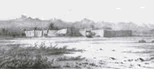
Creation of Fort Laramie
- 1834
·
John Astor, major owner of the American Fur
Company, became concerned about troubles with his company operations, and the
loss of easy-to-get beaver pellets. On June 1, 1834 he sold the company
to some St. Louis
investors.
·
William Sublette and Robert Campbell established
a log-stockade fort at the confluence of the Laramie and North Platte rivers to
trade with the Indians, and named it Fort William (later it was to become the
first Fort Laramie). In 1835, Fort
William was sold to Jim
Bridger, William Fitzpatrick, and Milton Sublette. In 1841, a rival fort,
adobe-walled Fort Platte was built on the Platte
River within a mile of Fort William.
In response to the construction of Fort
Platte, the American Fur Company
replaced the deteriorating log Fort William with a new fort called Fort
John, also made of adobe (this became
the second Fort Laramie).
·
1841 - The Bidwell-Bartelson party passes
Fort Laramie
enroute to California, the first true wagon
train bound for California.
·
1842 - Lieutenant John C. Fremont passes
on his first exploratory trip to the Rockies.
·
1843 - The Cow Column passes Fort Laramie.
This train represented the first of the wagon trains to Oregon.
·
1845 - Colonel Stephen W. Kearny councils
with the Indians at Fort
Laramie to insure safe
passage for the growing number of emigrants traveling along the trail. This is
the first peace council at Fort
Laramie. Jim Bridger
evidently made a trip to California
in the summer of 1845; and returned in September the same year. He brought back
to Fort Laramie
840 beaver skins, 675 dressed deerskins, 25 mules, 24 horses, 1400 California seashells.
·
1845 - Fort Platte is abandoned
·
1846 - The Donner Party passes through
Fort Laramie on their fateful trip to the west.
·
1847 - Brigham Young leads the first of
the Mormon emigrants through Fort Laramie in search of their Zion, the valley
of the Great Salt Lake.
·
1849 - Fort John (Fort Laramie) is
purchased by the Army for $4,000 on June 26th. The first garrison is comprised
of two companies of Mounted Riflemen and one company of the 6th Infantry.
·
1850 - The high tide of emigration passes
Fort Laramie, nearly 50,000 people.
·
1851 - Fort Laramie Treaty of 1851 (Horse
Creek Treaty) is signed.
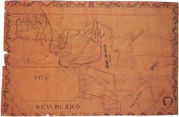
 The first map to clearly show the region was drawn by Father
Pierre-Jean DeSmet for Col. Donald D. Mitchell, Superintendent of Indian Affairs
for the St. Louis Department. It was used during the 1851 Fort Laramie Treaty
negotiations to show boundaries for the northern Plains Indian tribes. Jim
Bridger furnished the information for this map to DeSmet entirely from memory.
[Map from NARA Files, another one in color follows]
The first map to clearly show the region was drawn by Father
Pierre-Jean DeSmet for Col. Donald D. Mitchell, Superintendent of Indian Affairs
for the St. Louis Department. It was used during the 1851 Fort Laramie Treaty
negotiations to show boundaries for the northern Plains Indian tribes. Jim
Bridger furnished the information for this map to DeSmet entirely from memory.
[Map from NARA Files, another one in color follows]
Establishing of
Fort Bridger - 1842 to 1857 (Twelve miles from Carter, Utah)
Jim
Bridger established his trading post in the heart of the Indian Country in
1842. He and his trapper companions married women from neighboring Indian
tribes, and lived in a rude and primitive style. The fort grew to 13 houses and
outbuildings made of hewn logs, with planked floors and roofs. The roofs were
covered with sod. The buildings were enclosed by a stonewall [strong wall] 18
feet high, with bastions at each
corner. There was a coral inside for stock. Indians visited the fort three-four
times a year to sell their furs. Bridger made a living by exchanging cattle and
selling supplies to the emigrants who started to pass through the area as they
moved westward. Supplies of beaver were still numerous; although by 1847 they
started to dwindle. In 1846 the Donner Party stopped for three days
and discussed the best route to use to California. The Hastings Trail went
south of Salt Lake, then onto the Fort Hall road, then across the Sierra Nevada
Mountain range. This saved about 400 miles over the other routes. Bridger or
his partner, Vasquez, did not make recommendations, but it would profit them to
have more emigrants pass through Fort Bridger. Deep snows in the mountains
doomed the party.
·
1845 - There is evidence Bridger did make a trip
to California from which he returned in September 1845 and delivered to Fort
Laramie 840 beaver skins, 675 dressed deer skins, 25 mules, 24 horses, 1400 California
sea shells, the whole amounting to about $5000 exclusive of the California
shells which were separately valued at an unknown amount. [See Covingtons
Report] For a period of about four years it is thought that Bridger's travels
were concentrated in the southwest, west and northwest at least as far as Walla
Walla where his oldest daughter was attending the mission school run by Dr.
Marcus Whitman. In his stories around the campfire he could describe
characteristics of the mountain ranges, passes, rivers and plains as clearly as
if one were looking at them. When requested he would lay a deer skin on the
ground and build an accurate topographical map of an area with dirt and sand,
shaping it with his hands and drawing with his fingers. He explored and trapped;
returning to the Fort unexpectedly for a few months and then was off again.
·
·
. In 1847, 73 wagons
containing 143 Mormons under the leadership of Brigham Young passed through the
region, stopping at the fort. It was at this meeting that Young found Bridger
to be illiterate, untaught in religion, and living in conditions unsuited to
eastern ideals. He said he was going to the area that Bridger had earlier
discovered, the Great Salt Lake and establishes his base. [Brigham Young was en
route to Utah, a territory owned at this time by the Mexican Government.] Cayuse
Indians at Walla Walla on November 29, 1847 killed Dr. Marcus Whitman, his
wife, eleven men and took fitly men, women and children captive. Many were
never rescued or returned. Among these was Bridger's daughter, Mary Ann and
Helen Meek, daughter of former trapper friend Joseph Meek. The raiders were
later surrendered by the tribe, convicted and hanged by then U. S. Marshal Joseph
Meek. The news reached Bridger in April 1848 as Marshal Meek passed by the Fort
on his way to Washington D.C. carrying official papers relating to the
Territory of Oregon.
·
In 1848, Brigham Young
passed through Bridgers fort leading 5000 followers to Utah; and in the
ensuing years, their numbers increased.
·
On April 11, 1849,
Captain Howard Stansbury, of the Mounted Rifles at Fort Leavenworth, was issued
orders to march from the Platte to Salt Lake Basin, and survey the land. On
Saturday, August 11th 1849 he arrived at Fort Bridger, where Jim
Bridger and his wife welcomed he and his men. The fort was reported to be built
with pickets, with lodging apartments and offices opening internally to the
hollow square; and was protected from attack by a strong timber gate. Several
of the military wagons needed repair, and Bridgers blacksmith shop was at his
disposal. From the fort, there are two trails going to the Humboldt or Marys
River, where they unite. The old road connects with Bear River then goes down its
valley by Soda Springs to Fort Hall, then southwest to the Humboldt Mountains.
The other trail was created by the Mormons in 1847, and directs emigrants to
their city. Jims wife died at the fort while delivering their child, Virginia,
some three weeks later.
·
Rumor: After Jims Ute wife died in childbirth it was reported
by unknown sources, that he married a Mormon woman on July 4, 1849.
They soon parted, and it was reported that she spread many false rumors about
Jim to her friends, further exacerbating the tense situation.
·
Differences between
the harshness of Brigham Young and the compassion of Bridger and his freely
given support to anyone in need, led to the eventual destruction of Fort
Bridger:
·
·
Jim
was attuned to Indian ways, and if he were tolerant of another, they should be
tolerant of him, and on equal footing
·
Young
believed that the Indians were descended from the Lost Tribes of Israel. But
Bridger was here before him, and had cornered the Indian trade, was a trusted
friend, and had married into the tribe
·
Young
believed in military power and had forces at his command. Jim had armed the
whole Indian Snake tribe with modern rifles and their firepower was unsurpassed
·
Young
needed a monopoly on trade with the emigrants if he were to eliminate the
poverty of his followers. Jim was way ahead of him in that regard, as Fort
Bridger supplied all the wants of an emigrant, and was on the main trail to
their city. Additionally, Jim and Louis Vasquez had a store in Salt Lake City
itself.
·
Young
had led his followers to their Promised Land, but the country wouldnt grow
crops, just as Jim had predicted. This was very unsettling
·
Jims
generosity, hospitality, and friendships were too much in contrast with the
Mormon thrift. Young wanted his followers to make ends meet, but not to gather
wealth. Jim lived frugally, and gave half of all he gained, thus causing
greater rift between them
·
Young
came to Utah to be the most famous person there, but again Jim was there before
him, and commanded the title among all people, including Youngs followers.
·
Young
had earlier selected the area around Independence, MO as the site for their
temple. The local people there forced Young to depart. Jim had a farm nearby,
and Young thought it might have been Mormon land.
·
Finally,
Jim had performed many favors for the Mormons, as he tried to alleviate their
sufferings. Young wanted his followers to suffer the hardships of life. Young
couldnt forgive Jim for his favors to his flock!
On
August 16th 1849 the wagon train proceeded to Salt Lake City under
the command of Lt. Gunnison. Stansbury waited at the fort with Bridger, until
the 20th, when Jims business partner arrived back from a trip to
Salt Lake City. They followed the Mormon Trail for several miles, then cutoff
to the north and crossed the dividing ridge between the waters of Muddy Fork
(stream from Green River), and those to Bear River. They crossed the valley of
Tar-Spring Creek (tributary of Bear River), and joined back up with the main
trail. The cutoff had been abandoned because of an almost impassible hill at
the divide crest. On September 5th, they returned to Fort Bridger.
Later, Stansbury in his report to the Senate recommended that this be made into
a Military Post. After reviewing the land leading to Salt Lake City, Stansbury thought
that a road across the North Fork of the Platte, near Medicine Bow Butte, and
skirting the southern edge of the Laramie Plains, across the Black hills near
to Lodge-Pole Creek, and then descend that creek to the South Fork of the
Platte, a nearly straight line from Fort Bridger would be created. This would
avoid the ruggedness of the present trail.
On
September 10th, with Jim Bridger as guide, the group departed the
fort, and began traveling directly through the Indian war-grounds that lay in
their path. Jim stayed with the group until they reached their destination. This trail later became better known as the route used by
the Overland Express, the Pony Express and the Union Pacific Railroad route.
After returning home, he married a Snake woman.
1850 - A
Shoshone caretaker for Bridger's children became his third wife in 1850 and
when arriving back in Missouri near Little Santa Fe he bought what he termed a
small farm with 375 acres under cultivation and several hundred more forested
acres. With the help of a neighbor he built a log cabin for his family now
comprising a new wife and three children
In
1851 Brigham Young was appointed Governor of
the Territory and acting Indian Agent, after the Government acquired the land. This
year, starting about July 31st, Father De Smet departed Fort Union
[Junction of Yellowstone and Missouri Rivers] and traveled to Fort Laramie,
arriving on September 10th. With them were two 4-wheeled wagons and
two carts containing all their provisions. This is the first reported crossing
by wagons. The trail is about 800 miles in length. The party consisted mainly
of Father De Smet, Assiniboines, Minataries and Crow Indians. A Blackfoot
Indian was their hunter, who supplied them with game. Their journey took them
west, along the north side of the Yellowstone until they reached Fort Alexander
on August 11th, situated on the north bank of the Yellowstone
upstream of the Rosebud River. They rested for six days. During their rest, a
barge containing supplies for themselves and for the American Fur Company
arrived. They forded the river and then following due south, crossed the
Rosebud, Tongue, and Powder River forks, until reaching the Oregon Trail at Red
Buttes. Twenty-five miles from their final stop, Father De Smet carved a cross
into a large-high rock situated on the top of the Black Hills, meaning the
Big Horn mountains, which are presently called the Laramie mountains.
In
1852 Jim was still at Fort Bridger. Mrs.
Ferris [wife of Secretary of the Interior] reported on October 19th
1852, that the fort had a high wall of logs, stuck endwise in the ground.
Because the fort collects about $300,000 annually from the emigrants, the
Mormons filed suit to stop them. Nothing happened as a result of the suit.
 Sketch
of Fort Bridger - From Stansbury Survey Reports
Sketch
of Fort Bridger - From Stansbury Survey Reports
By
late summer 1853 difficulty between Jim Bridger and Brigham Young was tense.
They were both determined to each have right-of-way into the Great Basin. Part
of this trouble was attributed to the territorial legislature granting the
Mormon Church leader, D. H. Wells a charter to operate the Green River ferries
from 1853-56. Under this charter right, in March 1853, Brigham Young suggested
and encouraged William A. Hickman to settle on the Green River. Obediently,
Hickman, a Utah attorney and merchant, left Salt Lake with a good supply of
merchandise including a goodly supply of whiskey, which was then a major source
of revenue, with a view to establish a trading post on some good spot east of the
Basin entrance. The establishment of ferries and trading posts began. About May
he located on the Green River where he could intercept all immigration before
it reached Fort Bridger. He claimed to have cleared about $9,000 in three
months time. His profits were shared with many Saints crossing the ferry
as noted by Brigham Young in his Journal dated May 19, 1854. This trading post
was an added indignity to Jim Bridger who had been operating a post for many
years and was not content to see such lucrative trade going to others,
especially the Mormons. In July of 1853, Brigham Young recorded in his Journal
that William A. Hickman's camp on the Green River had been established and was
used by a Captain P. E. Marshall's Group.
In
October 1853, at a General Conference called by Brigham, fifty-three men were
asked to join Sheriff Hickman in either taking over Fort Bridger or
establishing an independent settlement. Brigham Young had fathered this idea to help the Saints who
were being bled of their money and goods by the Mountain men at Fort Bridger.
On November 26, 1853, these fifty-three men formed a posse and joined the
Hickman group. Together they made a futile attempt to take Fort Bridger by
force. After this failure, they went twelve miles south of Fort Bridger,
establishing Fort Supply on the route to Fort Bridger, and doing other
missionary work.
After
this attempt, the hatred of Bridger by Youngs followers became so intense that
Jim abandoned his fort, but not before hiring a surveyor in November to mark
off some 3,800 acres of land as a homestead. Young claimed he bought the
original Mexican Land title held by Bridger for $8,000, but records havent
been located. The newly established Fort Supply by the Mormons served its
purpose as a companion colony to Fort Bridger until it was destroyed. One of
the men involved in the above mentioned posse was Hosea Stout whose diary gives
many interesting insights concerning happenings on the Green River. The Diary
states that on May 1, 1854, Hosea Stout left for the Green River mission along
with others. He was totally unprepared, but joined the caravan placing his
luggage and provisions on a wagon driven by W. A. Hickman. A May 7, 1854 entry
states: "Arrived without incident...most god forsaken place I have ever seen."
However,
subsequent events proved that Bridger felt obliged to accede to their demands
to purchase, and didnt willingly dispose of the land and fort. Jim sent a
letter to Senator Butler stating that he was robbed and threatened by the
Mormons, and that all he possessed was stolen or destroyed. He asked $100,000
in compensation.
·
On October 21, 1858 documents were
recorded in Records Book B. p. 128 and dated August 3, 1855 that purported to
sell Fort Bridger to the Mormon Church represented by Lewis Robinson with the
sellers names, James Bridger and Louis Vasquez signed by H. OF. Morrell, Agent
in the presence of Almerin Grow and Wm. A. Hickman. In the same Book on pp.
125-127 another document of sale dated October 1 S. 1858 was also recorded on October
the 21 st. The price to be paid was $8000 in gold in each instance but methods
of payment were different. There were a number of inconsistencies and
peculiarities that make the transaction suspect. Vasquez had not been seen at
Fort Bridger since 1844 although he was in Salt Lake City on October 11, 1858
and could have received part or all of the money. Also he did sign one of the
sale documents. All the evidence would indicate that Bridger had no knowledge
of the sale and received no payments. He had refused at some point an offer of
$8000 and never signed or authorized the signing the signing of any deed. In
the summer of 1855 abridger was guiding Sir George and in October 1858 he was
back home at the farm.
In
1854, the Mormons spent $8,000 improving Fort Bridger, and initiated
settlements nearby. Bridger, having had to give up his fort, returned to the
east and bought a farm in Missouri. The farm life so devastated him that after
a short while he left it, and became a guide for travelers passing into the
western mountains.
On October 12, 1855, the Deseret News printed a letter,
possibly from Lewis Robison who was in charge of the fort for the Mormons. This
letter was sent to Bill Hickman tilling him of Indian troubles around Fort Bridger.
Brigham Young was quick to capitalize on the peaceful Shoshone. On August 11,
1856, as Superintendent of Indian Affairs, Brigham Young advised Bill Hickman
in a letter to meet with the Indians and hold a council with Washakie, their
chief. He was to advise them of the benefits of civilization and urge the
Indians to abandon their wandering and predatory mode of life, to cultivate the
earth and raise stock, and to locate themselves in schools that could be
established among them. Bill was told to collect as many Indians as possible
together at Fort Bridger and to call to his aid Lewis Robison of Fort Bridger
and Isaac Bullock of Fort Supply. So by August 19, 1856, after rounding up the
Indians, possibly with his wife Margaret in tow, Bill Hickman had met with
forty lodges of Indians numbering about 300 persons. "We smoked, had
dinner and gave them a beef, after which we had a treaty of Council with
Wash-i-kik and some 15 of his braves, explained the nature of Hickman's coming
and by whom sent. A good spirit seemed to prevail and after much conversation
adjourned till next day at which time Wash-i-kik was notified that he should
have another beef and also his presents as sent by Gov. Young per Wm. A.
Hickman..."
The
next day, the presents were distributed and it was reported in a letter signed
by William A. Hickman, Isaac Bullock and Lewis Robison of the friendliness the
Indians had shown to them. The Indians' orderly conduct did not always prevail
as indicated in a later letter by Daniel Wells: "A large amount of his
[Washakie] people came to the fort to have a spree." In addition, it
appears that they did have one because it was told about a few fights that had
taken place there. Washakie had even forced Robison to keep his store open
after hours to supply more whiskey. Indications are that the Indians probably
thought the Mormons supplied the presents, as the Mormons had been suppliers
for them previously. However, the Government had paid for the supplied the
gifts. Although the Mormons were the main beneficiaries, all settlers in the
region enjoyed the peaceful relations with the Indians.
·
In 1857, the Mormon
actions of opposing any interference by outside authority attracted the
attention of the Government, and troops were sent in the winter overland to
Salt Lake City. Jim Bridger, who had the reputation of the best guide in
America, was asked to lead them to the city. Earlier, in 1856, Major Van Vliet
had recommended to the War Department that they occupy Fort Bridger as their
own. The command was split, and the supply train with 160 wagons was attacked
near Green River. The Mormons attacked from the rear at night, the army stock
run off and the wagons burned, excepting for what they could carry with them.
The army men were stripped of arms and equipment, and were forced to return to
Fort Leavenworth, one thousand miles distant. Only eight survived the march.
Without these supplies to sustain them, the main party awaited at Blacks Camp
on Green River. It was so cold that the soldiers had to lie next to their
horses for warmth. In one night 600 horses and mules perished from the cold.
They were only 35 miles from Fort Bridger. It took them 15 days to reach the
fort. Arriving there they found it abandoned and burned to the ground. The army
moved two miles distant towards the mountain bluffs, and established Camp
Scott. Here they passed the winter. Captain Marcy took 40 men and marched to
Fort Massachusetts in New Mexico, for assistance. He returned in June with
supplies. Col. Hoffman arrived at about the same time with supplies from Fort
Laramie. The Mormons in the meantime constructed numerous dams and traps to
flood out the army should they attack the city.
·
Jim Bridger in 1857
executed a lease for his fort consisting of 3898-1/2 acres of land he had homesteaded,
to the government for ten years. He was to be paid $50 a month, and after that
period the land and buildings would revert to him [providing the government no
longer required them.] Bridger had to prove title to the land before payment
could be made. He claimed title under a Mexican Grant, and filed a survey at
the GLO in 1853. The government stated that he didnt perfect his title, and
all papers that were related to the fort were lost. In 1867 Bridger demanded
payment, but the government claimed that this fort was now included in the
reservation land, and belonged to the United States. Bridger tried several
times to apply for his rights under the Homestead acts, and was always denied.
After Bridgers death, the Secretary of War reported upon Bridgers claim, and
recommended that the Senate pay his estate for the value of the walls at the
fort appropriated by the government in 1858.
Fort Laramie Treaty of 1851 - Request to Build Forts
·
Treaty was authorized by
the Siuox Chiefs Council and signed on Sept. 17, 1851,
but not by two of the eight ruling chiefs of the Sioux. According to Statute
11, Article 2: The aforesaid nations do hereby recognize the right of the
United States Government to establish roads, military
and other posts, within their respective territories. Note that when the
treaty reached the Senate it was locked up and revised in secret by those
members and then placed into the archives. It never saw the light of day.
·
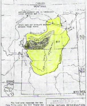
The
territory of the Crow Nation, commencing at the mouth of Powder River on the
Yellowstone; thence up Powder River to its source; thence along the main range
of the Black Hills and Wind River Mountains to the head-waters of the
Yellowstone River; thence down the Yellowstone River to the mouth of
Twenty-five Yard Creek; thence to the head waters of the Muscle-shell River;
thence down the Muscle-shell River to its mouth; thence to the head-waters of
Big Dry Creek, and thence to its mouth.
After the DeSmet map was
created, a detailed examination of the reservation revealed that the land area
was not closed. The treaty failed to connect the start and end points of the
reservation. In 1962 the Crow Tribe won a judgment for $10.5 million resulting
from the change in area downward from the 1851 treaty to a revised treaty of
1868.
·
Fort Laramie was
chosen as the site for the treaty, and government troops commanded by Captain
RH Chilton, arrived in August, camping nearby at Camp Macklin. Jim Bridger was
asked to attend and become the government interpreter. At the site were some of
Jims friends: Tom Fitzpatrick, Col. DD Mitchell, Robert Campbell, Edmund F.
Chouteau, and Father DeSmet. Also in attendance were many newspaper press
agents.
·
It was necessary to have a map available for
the meeting and was drawn by Father Pierre-Jean DeSmet for Col. Donald D. Mitchell,
Superintendent of Indian Affairs for the St. Louis Department. It was used
during the 1851 Fort Laramie Treaty negotiations to show boundaries for the
northern Plains Indian tribes. Jim Bridger furnished the information for this
map to DeSmet entirely from memory.
1852 - General Information
Jim Bridger reportedly
constructed a log raft, and floated down the Big Horn River. [Details and
sources are limited, so they are not included.] With the Raynolds Expedition
in 1859 he made this statement, but the actual day and month have not been
reported.
1853 - General Information
·
Bridger was 49 years old when he first became
involved in Westport. It was 1853, the fur business had been down the chute for
13 years, and he had lost the fort that he established on the Oregon Trail, to
the Mormons. He brought his family to this area, bought a farm near present
103rd Street and State Line. He had with him his third Indian wife, Mary, the
daughter of Shoshone chief, Washakie. Jim was no wandering squawman; he married
all three of his wives legally and sent the children either to St. Louis or Westport
to be educated.
Sir George Gores Hunting Expedition, Guide in Powder River Basin
(1856 - 1857)
·
Jim Bridger met with
Sir Gore at Fort Laramie late in 1854. Sir Gore hired Jim to guide him
throughout the Yellowstone area. They remained at the fort until early spring [1858],
when the expedition commenced. When they departed they had with them 40 men,
112 horses, 12 yoke of cattle, 6 wagons and 21 carts. They traveled up the
Platte to Casper Creek, then north to the Powder River. By summer they were on
the Yellowstone at the mouth of the Tongue River where they remained throughout
the winter. In the spring of 1856 they left the Tongue River area to Wolfs
Tooth Creek, from there to the headwaters of the Rosebud, and on to Wolf
Mountain. They returned to Tongue River and departed by flatboats to Fort Union
on the Yellowstone. The American Fur Company owned Fort Union. After getting
into a dispute with Major Culbertson, Sir Gore destroyed his game trophies and
equipment. He and Bridger floated down to Fort Berthold. After getting
established at the fort, Bridgers services were no longer required.
·
In the summer 0f 1854
he returned to his farm in Missouri, and completed arrangements to enlarge the
house. He had agreed to meet again with Sir. Gore in the spring of 1855. He started
off in April, and this was when Sir Gore started his rampage of animal
slaughter. During the winter of 1855-1856 they wintered on the Tongue River.
Jim, who was a hardened veteran, revolted against the meaningless slaughter;
and after a while used the money he received to go to Washington and complain
about the Mormon treatment of him at his fort on Green River.
·
From here Bridger
obtained a dugout canoe and paddled to Kansas City and his family. Trouble was
brewing with the Mormons, and Jim left for Washington to give his opinion to
the President. This was his first trip there after a 31-year absence. Upon his
return to Fort Laramie in 1857, he met Captain Marcy.
1856 General Harney Expedition of Yellowstone (Lt. Gouvenour
Warren of the Engineering Corps)
To support the expedition, Jim Bridger was hired at Fort Union
to guide them through the country. The expedition used the 1803 map prepared by
Nicholas King, and annotated it as they progressed through their assigned territory. This map was also annotated by Captain
William Clark in 1814; identifying the names of major streams and rivers in the
surveyed area. Some changes in names were made.
Mormon War, Guide for General Albert Sidney Johnston (1857 - 1858)
On July 16th, 1857 Jim was at Fort Laramie, and
was subsequently hired as guide for the Army of Utah, for the coming battle
with Brigham Young. Young pledged a scorched earth policy and prepared his
flock to retreat if needed. Jim guided the army wagon trains to Utah through
South Pass, a trail that Bridger helped discover in 1824. During the ensuing
months the Mormons again burned Fort Bridger, now operated by them. As the army
prepared for battle Jim leased his burned out Fort Bridger to the army for $600
per year on November 18th. Jim remained with the army troops
throughout the winter, teaching them to live in the snow. In the spring Young
conceded to the army wishes and disbanded his militia, and President Buchanan
pardoned him. Jims services were concluded so in July 1858 he put in for
discharge.
·
·
Bridger returned home
to Santa Fe. His second son William was six months old, and his wife had died
delivering his son.
·
·
Earlier, before the
trouble with Brigham Young started, Col Samuel H Woodson established a mail
route in 1850. Mail contracts were awarded for four-year stints. Woodson was
unpopular with the Mormons when it was discovered that he owned part of the
Temple Block in Independence, MO. Rates at that time through 1856 were:
Col Woodson carried monthly mail at $19,500 - 23,000.
FW McGraw received $13,500 plus extras
Heber & Kimball & Co
(Mormon) received $23,000
Jones &
Co Received $30,000
JM Hockaday received
for weekly mail delivery, $190,000
Russell, Majors &Waddell, Army Contractors,
received for weekly mail, $190,000+
·
In 1857 the
Heber-Kimball contract was lost because of the trouble with Young. The drivers
changed stock at Fort Bridger, Fort Laramie and Fort Kearny. At Fort Bridger
the trail splits: the northern route leads to Soda [Beer] Springs, the southern
route to Great Salt Lake City.
A comic opera Mormon War as it was referred to, ran
through the spring of 1858 without a shot being fired.
EXPLORATION OF THE YELLOWSTONE.
Washington, April 13, 1859. (W. F. RAYNOLDS, Lieut. Col., Engineer Corps)
·
Pierre Chouteau
recommended that Captain William F Raynolds engage Bridger as a guide to
explore the Yellowstone, its tributaries and the lands east and west of the
river. This was like a vacation to him, as he was well familiar with all of
that territory.
"WAR
DEPARTMENT, OFFICE, EXPLORATIONS AND SURVEYS, " Washington, April 13,
1859. [The Raynolds Expedition]
·
"SIR: Under
clauses of the military appropriation acts, providing for' surveys for military
defenses, geographical explorations and reconnaissances for military
purposes,' I am directed by the Secretary of War to instruct you to organize an
expedition for the exploration of the region of country through which flow the
principal tributaries of the Yellowstone river, and of the mountains in which
they, and the Gallatin and Madison forks of the Missouri, have their source.
·
" The
objects of this exploration are to ascertain, as far as practicable, everything
relating to the numbers, habits and disposition of the Indians inhabiting the
country, its agricultural and mineralogical resources, its climate and the
influences that govern it, the navigability of its streams, its topographical
features, and the facilities or obstacles which the latter present to the
construction of rail or common roads, either to meet the wants of military
operations or those of emigration through, or settlement in, the country.
"' Particular attention should be given to determining the most direct and
feasible routes: "
·
1. From the
neighborhood of Fort Laramie to the Yellowstone, in the direction of Fort
Union, on the Missouri.
·
2. From the
neighborhood of Fort Laramie northwesterly, along the base of the Big Horn
Mountains, towards Fort Benton and the Bitter Root valley.
·
3. From the
Yellowstone to the South pass, and to ascertaining the practicability of a
route from the sources of Wind River to those of the Missouri.
·
To accomplish these
objects most effectually the expedition should proceed by the Missouri river to
Fort Pierre. Here a large number of the Dakotas will be assembled to receive
their annuities, and overtures should be made to obtain their assent to your
proceeding to the source of Powder river by the Shayenne and its north fork, by
which a new route leading west from the Missouri river would be examined. To
aid you in accomplishing this object, the clothing, et cetera, to be given to
the Dakotas by the government, under the treaty made with them by General
Harney, will be turned over to you by the Indian Bureau for distribution.
·
" From the source
of Powder river the expedition should proceed down that stream to its mouth;
thence along the Yellowstone to the mouth of Tongue river, up which a
detachment should be sent to its source.
·
The remainder of the party
should continue on the Yellowstone to the mouth of Big Horn River, and ascend
the latter stream to the point where it leaves the mountains. Here the two
divisions of the party should be united.
·
The approach of winter
may require the expedition to pass that season in this neighborhood, or if time
suffices, the expedition may ascend the Big Horn River to Wind River, where a
favorable wintering place can be found.
·
" The next
season [1860] should be spent in examining the mountain region about the sources
of the Yellowstone and Missouri, to ascertain the character of the routes
leading south and west from the navigable parts of those rivers.
·
On returning one party
should descend the Missouri, using skin boats to Fort Benton, where a Mackinac
boat should be in readiness. The other portion should descend the Yellowstone,
in skin boats, to its mouth, where it should join the party with the Mackinac
boat, and all proceed to the settlements.
·
With a pack train it
would not, perhaps, be practicable to carry more than three months' full supply
of provisions, but the abundance of game in much of this region renders it
unnecessary to provide the usual quantity of bread and bacon.
·
·
" The
following places are convenient as depots, and you should make your arrangements
accordingly, viz: The Platte Bridge, Fort Laramie, and the American Fur
Company's posts, Fort Alexander Sarpy, Fort Benton, and Fort Union. If the
Dakotas should withhold their consent to the expedition proceeding up the
valley of the Shayenne, and you should not deem it advisable to make that
examination without their consent, the expedition will proceed to Fort Clark or
Fort Union, and move to the Yellowstone near the mouth of Powder river.
"You will use your own judgment in modifying the plan proposed in the
event of any unforeseen circumstances or physical obstacles preventing an
adherence to it. " You will endeavor by all the means in your power to
conciliate and gain the friendship of the different Indian tribes you may meet,
and will assure them of the good will of the government, and of its protection
in all their rights. You are authorized to purchase Indian goods to be used in
compensating the Indians for their services when required, and for purchasing
from them such articles, as you may need. By thus securing their friendly
co-operation you will not only be relieved from danger of interruption, but be
enabled to obtain from them much valuable information which would be withheld
if you were obliged to enter their country in a hostile attitude.
·
"To aid you in
the discharge of these duties, you are authorized to employ eight assistants as
topographers, geologist and naturalist, astronomer, meteorologist, physician,
&c., at an average salary not exceeding $125 per month, and to pay their
actual traveling expenses to and from the field of operations, and to subsist
them while in the field.
·
You will procure your
assistants, employees, equipment, supplies, &c., at those points, which
seem to ensure the most economical and effective organization for the party.
The sum of $60,000 will be set aside from the appropriations to defray the
expenses of the expedition, which amount your expenditures must not exceed.
"The colonel of topographical engineers will be directed to supply you
with such instruments as you may require on your requisition.
·
" The commanding
general of the Department of the West will be directed to detail an escort of
30 picked men of the infantry, under the command of a lieutenant, who will
report to you for duty. " Transportation for the provision and equipage of
the escort, their subsistence and their necessary, ammunition, will be
furnished respectively by the quartermasters', commissary, and ordnance
departments.
·
" The quartermasters',
commissary, medical, and ordnance departments will be directed to furnish, as
far as practicable, all necessary transportation, provisions, arms, and
supplies, those required for the civil employees to be paid for at cost prices
at the place of delivery, from the appropriation for the expedition.
·
" All necessary
transportation, provisions, arms, and supplies which you cannot obtain from
those departments, and all minor instruments, books, and drawing materials,
will be purchased out of the appropriation for the exploration.
·
" You will
communicate with the department through this office, to which you will make the
reports and returns required by regulations of an officer of engineers in
charge of a work or operation, and such other reports, transmitted as often as
the means of communication will allow, as will keep the department apprised of
your various movements, and the progress of the expedition under your charge.
·
On the completion of
your field duty you will return, with your assistants to Washington, and
prepare the maps and reports necessary to a full exposition of the results of
the expedition.
"Very respectfully, your obedient servant, "A. A.
HUMPHREYS, "Captain Topographical Engineers in charge.
"Captain W. F.
RAYNOLDS, "Corps Topographical Engineers, Washington."
·
· May
19, 1859 they picked up their military escort. By July they had reached the
Little Powder River. By September they were on Soap Creek [east of Big Horn
River.] The snow became so deep that Bridger advised Raynolds to stop the
exploration, thus they didnt reach the wonders of Yellowstone Park that year.
Jim was forced to have the group skirt around the south base of the Big Horn
Mountains, and pass through Jackson Hole and Spring Fork areas. [Note: Jim had
not been in this particular area since 1844.] The map Raynolds created from
Bridgers intimate detailed knowledge of the land was used for years. After
this excursion, ending in 1860, the Raynolds map was created from Jim Bridgers
knowledge of the territory. Next this brought him to lead the Berthoud survey
expedition of 1861.
·
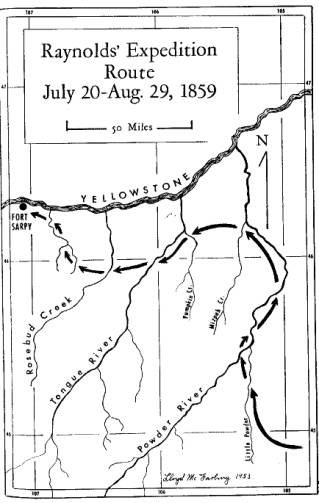
August 1859 Journey All Personnel
·
The group, including
Jim Bridger, traveled from St. Louis by steamers, Spread Eagle & Chippewa,
to Fort Pierre, then overland towards Fort Sarpy, leaving there on June 18th.
·
·
June 20
they arrived at Fort Pierre and remained there until the 29th,
delivering goods to the Indians, purchasing such articles for their outfits as were
needed and obtainable, loading wagons, and perfecting the other arrangements
for the journey. They had hoped to obtain horses from the Indians, but the
Indians were so perverse that nothing could be procured from them, save through
the medium of the regular traders. On June 23 they were visited by a party of
some 40 warriors of the Brule Sioux, under their sub-chief Medicine Cap, or as
he is generally known, the Frog.
·
June 29, they started directly west, following
the road to Fort Laramie. At the distance of about a mile from camp they
reached the bluffs, at the foot of which were a number of Indian graves, the
bodies being either enclosed in boxes, many of which were not more than four
feet in length, although containing the remains of adults, or else wrapped in
skins or blankets and laid upon scaffolds of poles from four to six feet in
height. Some of the bodies were rolled in scarlet blankets and flags, and other
votive offerings of cloth or ornaments decorated all the scaffolds. Through a
convenient ravine, a long gradual slope of about two miles brought us without
difficulty to the summit of the bluffs, where they entered a wide tableland so
nearly level that the eye could not detect the course of the drainage. Passing
some four miles over this high prairie, they reached the descent place to the
valley of Willow creek, a tributary to the Wakpa Shicha, or Bad river, or, as
called by the traders, the Teton. They soon reached the bed of Willow creek,
and camped after a day's march of eight and a half miles. This point is the
traders' usual camping ground for the first night after leaving Fort Pierre,
the rule being a short march for the first day.
·
·
Thursday, June 30. After leaving Fort Pierre
they followed the Fort Laramie road until this morning, about two miles from
camp, abandoned it, diverging to the north and crossing the ridge separating
the waters of the Teton from those of the Shayenne. The country is high but not
broken, offering no special obstructions to the passage of wagons. They camped
at night near the head of a small tributary of the Shayenne, which the guide
[Indian] calls Hermaphrodite creek. Its water was also found in stagnant pools,
and was quite warm, although not unpalatable. The distance traveled today was
19.3 miles.
·
Friday, July 1. They left camp at 5; o'clock,
the character of the country traversed being unchanged. On the right was the
valley of the Shayenne, which could be seen in the distance, the neighboring
bluffs presenting a rugged and forbidding appearance. Six miles from camp they
crossed the bed of another stream, Dry Wood creek by name, now consisting only
of a series of water holes, and resembling in its general characteristics those
previously described. At about 10 miles distance from the starting point of the
day, they entered upon a high plateau stretching out five or six miles and
ending at the bluffs of the Shayenne. Here they found their first serious
obstructions. The descent was very abrupt, and at one point it was found
necessary to attach ropes to the wagons and carts, and, having them thus
steadied, to lower them down by hand. A little labor will, however, render the
road perfectly practicable. Upon reaching the river bottom they crossed the
mouth of Plum creek, an insignificant stream, in whose passage they experienced
more trouble from mud than water, and camped about a mile beyond in a grove of
cottonwood trees, upon the banks of the Shayenne, which, at this point, is
muddy and rapid, resembling the Missouri upon a diminished scale. It is the
first running water they have seen since leaving the Missouri, a distance of 63
miles. The group continued on, using the Indian guide until July 21st.
The Sioux Indian guide took off on the 20th, taking with him a mule,
saddle and bridle. [Later, on September 8, 1860, Raynolds again met his guide
while visiting Fort Pierre.]
·
 Thursday,
July 21. The night passed quietly and we did not start until about 6 o'clock.
Our route lay up the fork of the Little Missouri, some little distance from the
stream, that we might avoid the numberless gullies and the inevitable sage,
whose perpetual recurrence rendered our line of march very devious. We crossed
several tributaries of the Little Missouri, now dry, one being distinguished by
a little timber upon its banks. Barren sage and cactus plains and naked hills
describe the country through which we have passed today, the latter having been
apparently once covered with grass, since eaten off by the buffaloes, which
have been today seen in large numbers upon all sides. Some of these animals
came very boldly up to the train, and, in one or two instances, with very
ludicrous results. Three large bulls charged down upon us at one point in the
march, to the great alarm of one of the escort, who dropped his gun, and,
raising his hands, exclaimed, in all the accents of mortal terror,
"Elephants! elephants! my God! I did not know that there were elephants in
this country! " On another occasion, as a band was passing close by the
train, one of the teams started in full pursuit, and was with great difficulty
checked. It was probably the first buffalo chase on record with a six-mule
team. As we approached the head of the stream we commenced looking for water
and a camp, and a spring was ultimately found that flowed after cleaning out,
and by digging we obtained the luxury of pure and cool water of the temperature
of 50 deg. Another attempt at digging at a distance of 30 feet brought water,
however, from a different strata, the temperature being 10 deg higher. We are
now within a mile or two of the drainage of Powder River, and as soon as we
shall have passed the crest before us will be out of the Sioux or Dakota
country. The fires still continue in the distance; but no Indians have made
their appearance, and their promise to permit us to pass through unmolested has
been unbroken. Except for purposes of communication with our Indian guide the
interpreter has been useless. My American guide, Bridger, is now on familiar
ground and appears to be entirely at home in this country. I therefore
anticipate no difficulty in dispensing with the services of our fugitive
Indian.
Thursday,
July 21. The night passed quietly and we did not start until about 6 o'clock.
Our route lay up the fork of the Little Missouri, some little distance from the
stream, that we might avoid the numberless gullies and the inevitable sage,
whose perpetual recurrence rendered our line of march very devious. We crossed
several tributaries of the Little Missouri, now dry, one being distinguished by
a little timber upon its banks. Barren sage and cactus plains and naked hills
describe the country through which we have passed today, the latter having been
apparently once covered with grass, since eaten off by the buffaloes, which
have been today seen in large numbers upon all sides. Some of these animals
came very boldly up to the train, and, in one or two instances, with very
ludicrous results. Three large bulls charged down upon us at one point in the
march, to the great alarm of one of the escort, who dropped his gun, and,
raising his hands, exclaimed, in all the accents of mortal terror,
"Elephants! elephants! my God! I did not know that there were elephants in
this country! " On another occasion, as a band was passing close by the
train, one of the teams started in full pursuit, and was with great difficulty
checked. It was probably the first buffalo chase on record with a six-mule
team. As we approached the head of the stream we commenced looking for water
and a camp, and a spring was ultimately found that flowed after cleaning out,
and by digging we obtained the luxury of pure and cool water of the temperature
of 50 deg. Another attempt at digging at a distance of 30 feet brought water,
however, from a different strata, the temperature being 10 deg higher. We are
now within a mile or two of the drainage of Powder River, and as soon as we
shall have passed the crest before us will be out of the Sioux or Dakota
country. The fires still continue in the distance; but no Indians have made
their appearance, and their promise to permit us to pass through unmolested has
been unbroken. Except for purposes of communication with our Indian guide the
interpreter has been useless. My American guide, Bridger, is now on familiar
ground and appears to be entirely at home in this country. I therefore
anticipate no difficulty in dispensing with the services of our fugitive
Indian.
·
Trail Map from
Exploring the Northern Plains 1804 to 1876, by McFarling 1955; pg 251.
On
August 1, after reaching the Powder River camp, Bridger searched for a route
across the hills towards the Tongue River. He reports that they should be able
to at least cross Mizpah Creek [branch of the Powder.] They discover that the
maps they were using were incorrect. Bridger correctly pointed out the route,
and his selection the road to Fort Sarpy proved his excellence as a guide.
·
Later the expedition
forded the Big Horn without trouble about a mile and a half above its mouth, or
about half a mile below the junction of Tullock's creek, and again about 35
miles above. These fords were well marked by Indian trails leading to them, and
are the principal if not the only crossings, as repeated attempts made at other
points by naturalists, hunters, and other members of the party uniformly
failed, the depth of water and rapidity of the current deterring the most
daring.
·
Tuesday, August 23. Soon after dinner today Lieutenant Maynadier returned to
camp, and with him came Mr. Robert Meldrum, the agent of the Fur Company, who
is in charge of the long-expected boats, which are still some 20 miles
below. It has been found almost impossible to navigate the Yellowstone, the
water being too low, although the vessels, which are batteaux, draw only 18
inches. At Mr. Meldrum's suggestion I shall send down a number of the wagons
to-morrow to receive part of the freight and thus lighten the load. The
afternoon and evening was spent in conversation with Mr. Meldrum, obtaining
information from him with reference to the most feasible routes before us and
the peculiarities of life among the Indians. He is undoubtedly the best living
authority in regard to the Crows, outside of the tribe, having spent over 30
years in their country, during that time visiting the regions of civilization
but once, and on that occasion spending only 19 days in St. Louis. He has long
lived among these Indians, assuming their dress and habits, and by his skill
and success in leading their war parties has acquired distinction, rising to
the second post of authority in the tribe. He of course speaks their language
perfectly, and says that it has become more natural to him than his mother
tongue. I noted the alacrity with which he ceased speaking English whenever an
opportunity offered. The Indians were so troublesome about camp today that I
posted a double guard at night for the purpose of freeing us from the annoyance
of their visits.
·
Wednesday, August 24. -Six wagons started this morning for the boats under the
wagon master, accompanied by a guard, with Mr. Meldrum acting as guide. The
Crows are still swarming about camp, although they have not been quite as
troublesome as for a few days past. The men do not seem dishonest, and Mr.
Meldrum says that we need not distrust them, but added that the women and
children would steal everything possible, and it has therefore been found
necessary to keep a rather strict watch upon all portable articles. Our mules
and the beasts of the Indians have thoroughly consumed the grass in this
vicinity, and it will be soon necessary to find new pasturage. Our animals are
immensely improved in condition by the rest and nourishing food obtained during
our halt.
·
Thursday, August 25. -The wagons that were sent to meet the boats returned
this evening with full loads, and there are now hopes that we shall be able to
resume our march from this point in a few days. The day was chiefly spent
writing and computing. The Indians, save two or three lodges, all left today
and ascended the river to Fort Sarpy, where they will await the arrival of the
boats with their annuities.
·
Friday, August 26. -The long-expected boats came up this evening, but our
supplies are so confused with those of the Fur Company and of the Indian agent,
that it will be necessary to unload the cargoes entirely, and I have therefore
concluded to have them push directly on to the fort where we will join them on
Monday. The afternoon and evening were spent in obtaining information in regard
to the country between the Yellowstone and the Platte. I had a skeleton map
prepared showing those points with which we are acquainted, and Mr. Meldrum has
filled in the leading features from memory. The information thus obtained will
be of the greatest value, as it will enable a separate party to reach the head
of Powder River, a matter of much importance as I cannot obtain a second guide,
and propose exploring two routes from this point. As we shall pass through the
country we shall have an opportunity of verifying Mr. Meldrum's statements and
testing the accuracy of his topographical knowledge. High winds prevailed at night
and the sky was obscured by scattered clouds, but not sufficiently to prevent
observations.
·
Saturday, August 27.
- The entire day was consumed in preparations
for the resumption of our journey, and especially in arranging for the division
of the expedition into two parties for separate explorations.
·
Wednesday, August 31 - Some complications in the settlement of the provision
account occasioned an unexpected delay this morning, and it was not until 10
o'clock that we finally left Fort Sarpy, around which, as we moved off, all
Indians were collected receiving their annuities from Major Schoonover. We
pushed up the valley of the Yellowstone for nine miles over a barren, dusty
plain, with scarcely the semblance of vegetation upon it, the soil resembling the
dry bed of a stream, and the dust raised by the train filling the air. Turning
to the left, up a small valley which looked as unpromising as any that could be
imagined, we continued our journey three miles further, when we found a living
spring and a tolerable supply of grass. The water was far from the best, but
still was palatable, and we therefore encamped. The Yellowstone, for 10 or 15
miles above Fort Sarpy, flows entirely on the north side of the valley, having
a wide plain on its right bank. The timber is confined entirely to the river's
edge and is not very abundant.
·
Thursday, September 1. Our route this morning bore up the valley of the stream
upon which we had encamped, and the traveling was detestable, although our
previous experience has reconciled us to the worst roads and given confidence
in our power to overcome all obstacles. The great obstruction today was sand,
in which our newly laden wagons sank deeply and seriously tried the power of
our animals. One of our teams stalled and, falling behind, caused a delay of an
hour or more. We continued up the stream to the point at which it forked, and
thence up the western fork, the valley of which soon becoming too narrow
compelled us to cross the bed of the intervening stream, causing considerable
labor, and to take to the hills. At this point I drove ahead with
Bridger, and from a convenient ridge obtained a view of the country before us. The prospect was
decidedly inauspicious, the whole surface of the adjacent hills being cut up
into steep gorges, and the chances for passable roads appearing to steadily
decrease. Under such circumstances, I ordered a search for water with a view to
encamping, and ultimately an oozing spring was found in a neighboring valley,
which by digging yielded enough for the men but left none for the animals.
Bridger, however, was more successful, and found an abundance of water in a
valley some two miles distant, to which the herd was driven. Bridger reports
that our route tomorrow will be into and down the valley of Tullock's fork, a
branch of the Big Horn, which we are approaching, and as I propose that
Lieutenant Maynadier shall go up that stream, I gave him his orders that he may
make his arrangement to leave us when we strike the creek. The grass at our
camp tonight is tolerably good.
·
· Friday, September 2. The road this morning continued up the valley in which we
had encamped, thence along the ridge for about a mile, and then turned down a
small creek that flows into O'Fallen's or Tullock's fork of the Big Horn. We reached
the latter stream at about noon after a march of seven miles. At this point
Lieutenant Maynadier and party separated from us, ascending the fork, while we
continued down to the Big Horn, arriving at that river after a further advance
of seven miles, and pitching our tents upon its right bank. The division of the
party was a necessary step, and we separated in excellent spirits and with
mutual and fervent good wishes. The road today has been very poor, and until we reached the
valley of Tullock's creek the hills were so steep that it was barely possible
to cross them. West of the ridge gully after gully intercepted our progress,
and at times we were forced into the bed of the streams, where the sand or
stones formed serious obstacles. These circumstances, added to the delay
occasioned by the separation of the parties, made the day a very laborious one,
and we were iu the saddle between nine and ten hours, although the distance
travelled was less than 15 miles. One of our horses escaped this morning, and was
pursued by Mr. Wilson and one of the men, who have not as yet returned. In all
probability they were compelled to return to Fort Sarpy, in which case they
will have over 50 miles to travel, and cannot get back before to-morrow
afternoon. Dark clouds have filled the sky in the northeast all day, and a cold
north wind blowing this evening rendered a fire necessary for comfort. and
eventually culminated in a storm, which has prevented observations and caused
serious personal discomfort.
·
Saturday, September 3. -The storm of last night had not abated this morning and
did not cease until 10 a. m., leaving then a mud in which locomotion with
loaded wagons is impossible. This fact and the non-arrival of Mr. Wilson led me
not to move camp. Mr. Wilson ultimately returned about 3 o'clock in the
afternoon, bringing with him the missing horse which he had found at Fort
Sarpy. He passed last night in the Indian village as the guest of Red Bear, the
head chief. He reports that the whole village of 130 lodges is upon our trail,
and that they propose accompanying us to the head of Powder river. This is
decidedly overdoing the matter of amicable relations. A single guide would be
of invaluable service, but the continual company of 500 savages of all ages and
both sexes, devoid of any strict ideas of property, expecting to be allowed
free access to our stores, and with a general friendship for our portable
articles rather than for our persons, can hardly be esteemed one of the leading
advantages to be derived from amity with the aborigines. They have not shown
themselves as yet, however, and I am in hopes that their usual lack of veracity
will not fail in this instance, and that they will break the promise made Mr.
Wilson, which, in this case, as far as we are concerned, is more to be honored
in the breach than the observance. The guide states that the best route up the
valley of the Big Horn will lie for some distance at least on the west side of
the river. Search has therefore been made during the day for a good crossing, and
one has been found above camp which will answer, although rather deep. Our
escort being now reduced to 14 men, one-half having been detailed for duty with
Lieutenant Maynadier, we have not the force to post a guard of soldiers every
night. I have therefore been obliged to make a detail from my teamsters and
packers, and to use my assistants as officers of the guard. The chilly nights
do not tend to render this service one of the luxuries of frontier life.
·
Sunday, September 4. I had desired to improve the first clear sky afforded for
astronomical observations, to determine the position of our present camp and
also of the mouth of the Big Horn river, but failed in this last night. The air
this morning was quite cold, the thermometer standing at 340~. After our usual
religious services, I finally succeeded in getting morning and afternoon
observations for time, and circummeridian observations of the sun for latitude,
which will be enough to give the position of the camp with tolererable
accuracy.
·
· Monday, September 5. -Some of the party having discovered a good ford below
camp, our route this morning ran down the stream that we might take advantage
of it. The ford proved to be when the valley of the Yellowstone becomes a route
for emigrants. It is midway between Tullock's or O'Fallen's creek and the
junction of the Big Horn with the Yellowstone, and probably three quarters of a
mile or a mile above the latter point. In going from the east to the west side
of the river the route inclines well up the stream, and at the present stage of
the river we found the water not over the' axletrees of our wagons. In fifteen
minutes from the time the first team entered the water the last was on the
opposite bank, having passed over a firm, stony bottom. Some little clearing
was required upon the west bank, and then the train moved rapidly up the
valley. About ten miles from the ford a bend of the river compelled us to cross
a ridge of hills for a mile or two, both the ascent and descent being
accomplished with difficulty by reason of the steepness of the slope and the
heavy loads in our wagons, but still the obstacles were slight compared with
others previously overcome. After again reaching the valley, search was at once
commenced for a camping ground, but the scarcity of grass compelled us to
travel three or four miles further before halting. We at last selected a spot
upon the river, furnishing on the low ground scanty pasturage for our animals,
which we were compelled, however, to eke out with the bark of young cottonwood
trees. Artemisia covered the ground over which we have traveled today,
seriously inconveniencing the progress of our vehicles. This and the hills that
we were compelled to cross, as mentioned above, were all, however, that marred
the excellence of the road. We traveled 16 miles in all, or about 16 miles
after crossing the river. Our course has been nearly magnetic south, or from
15~ to 200 west of due south. The promise of our Indian friends excellent, and
will be of importance
·
Col Haydens Summary
of the Local Area (pgs 8-13) 1859 Survey Notes
·
The valley of the Yellowstone can be reached
with comparative facility near its mouth, or near the junction of the Powder,
but between these points the country lying to the east is represented, by all
who have passed over it, as broken, barren, and impracticable. At the eastern
base of the Big Horn mountains there is a belt of country some 20 miles in
width that is peculiarly suitable for a wagon road, and which I doubt not will
become the great line of travel into the valley of the Three Forks.* Being
immediately at the base of the mountains, this strip is watered by the numerous
streams which rise in the hills but soon disappear in the open country below,
while the upheaval of the mountain crest is so uniform in direction that a
comparatively straight road can be laid out close to their foot without
encountering grades that are seriously objectionable. I travelled through this
region with heavily loaded wagons in the fall of 1859 without embarrassment.
The valley of the Big Horn, from latitude 430 30' to latitude 450 10' north, is
surrounded on all sides by mountain ridges, and presents but few agricultural
advantages, The geological structure of the mountains, however, would lead us
to expect valuable mineral deposits in the ridges. This region is totally unfit
for either rail or wagon roads
*NOTE FOR 1867.-The recent developments of this
country have opened this route by the foot of the Big Horn range, and forts are
now established along the entire line. The tributaries of this river-the
Powder, the Tongue, the Rosebud, the Big Horn, Pryor's, and Clark's forks-all
flow to the north until they reach the Yellowstone. Further west the same is
true with reference to the Yellowstone itself, which near its source flows for
more than 100 miles to the northward before changing its course to the east.
The first stream west of the ridge is Powder river, (which derives its name
from the sulphurous vapors rising from burning beds of lignite in its
vicinity,) of which the Little Powder is the main tributary from the east. The
latter rises near Pumpkin Butte, flows through the " bad lands" for
over 100 miles, and joins the main stream in latitude 450 28'. This stream,
when crossed by us in July, 1859, was almost dry. Its valley is wide, and
contains the usual growth of cotton-wood. Clear fork is the principal western
tributary of the Powder, and leaves the Big Horn Mountains, in which it takes
its rise, a dashing mountain torrent. Upon its banks is found considerable
pine, which the excellent water-power of the stream will in time convert into
lumber for the use of the coming settlers. Crazy Woman's fork and Willow creek
are less important tributaries of the Powder, finding their sources in or near
the mountains, and emptying into the main stream above Clear fork. The Powder
itself rises in the Big Horn mountains, about latitude 43~ 25', flows northeast
about 60 miles, then turns to the north, and empties into the Yellowstone in
latitude 46~ 42'. Its valley (which is barren and yields but little grass and
an abundance of aftemisia) averages a mile in width throughout its entire
length, until within 50 miles from its mouth, it becomes narrower and the
bluffs more ragged and broken. Travelling in it is greatly impeded by deep and
almost impassable ravines which cross it at nearly right angles, and are
concealed by the sage until their very edge is reached. These gullies are
caused by the action of the water upon the light soil, and are among the most
disagreeable features of the country. The bed of the river is mainly a
treacherous quicksand, and great care is necessary in selecting fords. The
depth of the water is not, however, such as to offer any obstruction, except
during freshets. The bluffs bordering the valley are throughout the
much-dreaded and barren " bad lands," and this stream must ever
remain of little or no value to the country. Tongue river rises in the Big Horn
mountains, and is in some respects an improvement upon the Powder. Its valley
is narrower, but contains less sage and more grass. The stream flows in the
main over a gravel or stony bottom, and thus presents no especial obstructions
to crossing. The river bottom is less torn up by gullies, and the bluffs are
not as rugged and impassable. Yet the Tongue river valley presents few
attractions to the settler. The soil is light, and the timber chiefly
cottonwood, and scarce-disadvantages that will for years seriously affect its
prospects for settlement and development. The third tributary of the
Yellowstone is the Rosebud, which rises in the Chetish or Wolf mountains, and,
during our journey in August, 1859, contained no running water. Its valley is
narrow, and resembles that of the Tongue. Near its source, however,. are some
open valleys, that by contrast appear attractive. The Big Horn, which is next
reached, is the main tributary of the Yellowstone. It is formed by the junction
of the Popo-Azie and Wind rivers, both of which are considerable and noted
streams. Thirty miles below the point of junction the river enters the
mountains, passing through a cafion 20 miles in length, after which it flows
among broken and barren hills, occasionally interspersed with small level
valleys. During this part of its course, which is nearly 100 miles in extent,
it receives several tributaries, of which the chief are No Wood and No Water
creeks on the east, and Gray Bull and Stinking rivers upon the west. This part
of the country, as will be seen from the detailed statements of Lieutenant
Maynadier's explorations, is repelling in all its characteristics, and can only
be traversed with the greatest difficulty. Below the mouth of the Stinking, the
Big Horn again enters the Big Horn mountains, and passes through a second
cation of 25 miles in length, emerging in latitude 450 10'. The peculiar
topography of this region, whereby the same river flowing to the north cations
twice through the same mountain range, is well set forth and made plain in the
rough language of the guide Bridger, who said: " The Big Horn mountains
are just the shape of a horseshoe, and the Big Horn river cuts through both
sides, dividing the heel from the toe." The lower canion must present a
series of views of great magnificence. The gorge cannot be less than 3,000 feet
in depth, and whether the banks are sloping or perpendicular, the scenery must
be grand in the extreme. Bridger, who claims to have once passed through on a
raft, declares that for mingled sublimity and beauty this canion is unequalled
by any that he has ever seen. Below this the Big Horn flows some 10~ east of
north for about 70 miles to its junction with the Yellowstone. The valley is
open, and from two to five miles in width, being bounded on either side by high
rolling prairie hills. Near the Yellowstone it is crossed by a high spur of the
Chetish mountains, on the top of which is found a stunted and straggling growth
of pines. The soil improves as you ascend towards the mountains, and near the
lower canon is very fertile, and covered with as heavy and luxuriant a crop of
grass as could be found upon the continent. For 30 miles above its mouth the
Big Horn flows upon the east side of its valley, but shifts to the other about
half the distance to the mountains. The expedition forded the Big Horn without
trouble about a mile and a half above its mouth, or about half a mile below the
junction of Tullock's creek, and again about 35 miles above. These fords were
well marked by Indian trails leading to them, and are the principal if not only
crossings, as repeated attempts made at other points by naturalists, hunters,
and other members of the party uniformly failed, the depth of water and
rapidity of the current deterring the most daring. At these fords the water was
only from two to two and a half feet in depth. The river bed, throughout its
entire course below the mountains, partakes of the general character of the
Yellowstone and Missouri, the stream being crooked and badly cut up by islands
and sandbars. Of the tributaries of the Big. Horn below the mountains those
upon the west were not visited by us, nor are they of much importance. Of'
those upon the east the firs; is Tullock's creek, which empties into the main
stream about two miles above the Yellowstone. It rises in the Chetish
mountains, and flows through a timbered valley about 50 miles in length, so wide
that it was mistaken at first for that of the Big Horn or Yellowstone. The
stream itself, however, contains but little water, and this in October, 1859,
was found only in pools. The second of the eastern branches is the Little Horn,
or, taking a literal translation of the Indian name, the "Little Big
Horn." This empties into the main stream about 30 miles above Tullock's
creek, and flows through a wide bottom towards the north, its length being 60
or 70 miles. Upon its upper tributaries several good camping grounds are found
near the base of the mountains. Of the rivers that unite to form the Big Horn,
the Popo-Azie is a short stream, formed by the union of several branches which
rise in the southern part of the Wind River chain anid to the northward of the
South pass. These do not unite until near the junction of the Popo-Azie with
Wind river. Its drainage is entirely from the mountains and the supply of water
is therefore quite constant. Wind river rises near the northwestern extremity
of the Wind River range and flows to the southeast parallel with those
mountains and between them and the Big Horn range. Its course is such that a
glance at the map leads to an inquiry why it does not flow into, and form a
continuation of, the Platte, instead of abruptly changing its course and
discharging its water through the Big Horn into the Yellowstone. This is at
once solved by an inspection of the profile of our route between those streams,
by which the point of junction of Wind river and the Popo-Azie is shown to be
200 feet below the level of the Platte at the Red buttes. Wind river is rapid
and filled with boulders, and its valley is narrow and unproductive. The
mountains upon either side are bold and lofty, and present a constant
succession of striking landscapes. At the sources of the stream is a lofty
basaltic ridge, rising from 12,000 to 13,000 feet above the ocean, stretching
across the head of the valley, and connecting the dividing crest of the Rocky
mountains with the Big Horn range. Near this point and on the dividing crest,
in latitude 430 28', a peak rises 13,750 feet above the ocean level, (as
determined by angle of elevation taken from route,) which may justly be
considered as the topographical centre of North America, the rain which falls
upon its sides being drained into the Gulf of Mexico through the Mississippi,
the Gulf of California through the Colorado, and the Pacific ocean through the
Columbia. I have designated this mountain on the maps as " Union
peak." West of the Big Horn, the other tributaries of the Yellowstone are
Pryor's river, Clark's fork, the Big Rosebud, and Beaver river. These streams
are comparatively short and small, find their sources in the mountains, and
flow to the north. Beyond these is the valley of the upper Yellowstone, which
is, as yet, a terra incognita. My expedition passed entirely around, but could
not penetrate it. My intention was to enter it from the head of Wind river, but
the basaltic ridge previously spoken of intercepted our route and prohibited
the attempt. After this obstacle had thus forced us over on the western slope
of the Rocky mountains, an effort was made to recross and reach the district in
question; but, although it was June, the immense body of snow baffled all our
exertions, and we were compelled to content ourselves with listening to
marvellous tales of burning plains, immense lakes, and boiling springs, without
being able to verify these wonders. I know of but two white men who claim to
have ever visited tlis part of the Yellowstone valley-James Bridger and Robert
N Meldrum. The narratives of both these men are very remarkable, and Bridger,
in one of his recitals, described an immense boiling spring that is a perfect
counterpart of the Geysers of Iceland.
·
During the following
season, Bridger established a passable wagon road on the west side of the Big
Horn Mountains. It was this trail that he used in his 1864 race with John
Bozeman. Earlier at the start of
the Raynolds expedition, Bridger guided the survey party down the east side of
the Big Horn Mountains, close to the mountains. [John Bozemans route was
further to the east, where the travel was easier.]
·
·
Raynolds Expedition
- 1st Lt John Mullins Route from Fort Benton to Fort Union (1st
Team)
·
·
This was a split
survey party from Raynolds main force initiated July 18, 1860. Mullins was to
march by foot to the headwaters of the Yellowstone, while Raynolds went by
boat. Mullins was to determine the dividing ridgeline between the Missouri and
the Yellowstone. A detailed field map was to be prepared. Assigned to him were:
James Bridger, Guide; Dr FV Hayden, Naturalist; A Schouborn, Artist &
Metrologist; WD Stuart, Topographer. He was to reach the junction by August 20th
and proceed to Fort Randall.
·
·
The group left on the
20th and traveled mainly eastward. The daily locations and mileages
were:
·
|
Date
|
·
Distance (Miles)
|
·
Remarks
|
|
·
July 20
|
·
1-1/2
|
·
East to clear stream at Highland Spur of Belt
Mountains, empties into Missouri River
|
|
·
|
·
13-1/2
|
·
Followed Indian Lodge trail to spring. Spring
was from coming from a 300 ft high bluff
|
|
·
July 21
|
·
3
|
·
South on trail, had to abandon odometer cart.
Barometer was broken, but used boiling water to establish elevation.
|
|
·
|
·
2
|
·
Followed Flathead Indian trails for 4-1/2
miles. 1-1/2 mile further came to mouth of Arrow River, running along base of
high bluffs 250 feet above valley floor. (Total = 11 miles)
|
|
·
July 22
|
·
---
|
·
Followed Indian trail to top of cliff
|
|
·
|
·
13
|
·
Traveled east across level grassland, crossed
a creek, no timber.
|
|
·
|
·
2
|
·
Continued to another creek.
|
|
·
|
·
5
|
·
Marched east by north through ravines. To dry
creek. Followed creek bed for 1-1/2 miles where we found swift flowing water.
Bridger said this was Judith River. Found traces of large Indian encampments,
reported to be Blackfeet. Latitude is 47.17.56. Using field glasses Devils
Gate is visible on the Missouri River.
|
|
·
July 23
|
·
3-1/2
|
·
Traveled SE and camped on branch of Judith,
about 1-1/2 mile above its junction with the main river.47.14.13.
|
|
·
July 24
|
·
5
|
·
Crisscrossed Judith traveling east by south.
Saw some Indians and sent Bridger with an advance party to see who they were.
They were Blackfeet Little Robes , whos village was ½ mile distant. 54
lodges or about 150-200 Indians. Exchanges gifts and received buffalo meat.
Bridger was interpreter.
·
Latitude 47.06.39.
|
|
·
July 25
|
·
14
|
·
Followed creek then left it for high ground to
the summit of Judith Pass. [Divide between Muscleshell and Judith Rivers.]
|
|
·
|
·
11-1/2
|
·
Marched to Muscleshell and camped. Mountains
of 25-Yard River visible to south.
|
|
·
|
·
|
·
|
·
·
·
·
Henry E.
Maynadier, Captain 10th Infantry Expedition Party (Raynolds
Decision to Divide the Survey Team 2nd Team)
·
·
Lieutenant Maynadier is to descend the Big Horn
to the point at which the full survey party left it in September 1859, and then
proceed westward along the base of the Big Horn Mountains, crossing the
Yellowstone and reaching Three Forks by Clark's rout; the understanding being
that both groups shall meet at the Three Forks junction on the last day of
June. Raynolds deemed it important that the groups should meet at the junction
by this date for the following reasons:
·
On the 18th of July there will be a total
eclipse of the sun, which is attracting such attention in all scientific
circles. Raynolds orders from the department require that, if possible, he
should visit the line of the total eclipse in British America, (permission
having been obtained for this purpose from the authorities of those provinces,)
and take such observations as may be possible.
·
Raynolds proposed, after reaching Three Forks
and meeting Lieutenant Maynadier, to leave the expedition, and with three or
four attendants to push on ahead to the north, obtaining new horses at Fort
Benton, and advancing into the wilderness beyond the international boundary,
reaching the eastern base of the mountains north of latitude 52º, just within
the line of total eclipse. The distance from the Three Forks will be about 500
miles, and if both two parties meet on June 30th, as agreed, he would have 17
days in which to reach the desired point. This will require an average day's
march of about 29 miles.
1860
Westport Revisited
In 1860 he is said to
have purchased A.G. Boone's two-story home on Grove Street (Pennsylvania),
dismantled it, loaded it into wagons and re-assembled it upon his farm near new
Santa Fe.
·
Captain E L Berthoud, Engineer Corps
Expedition of 1861.
Russell & Holladay, operators of the Overland Stage
Company, were seeking a more direct route from Denver to Salt Lake City.
·
·
During this excursion,
Jim was often called upon to correct the groups engineering estimates, as he
had an unerring eye for distances and heights. Jim established the route
through Berthouds Pass to Provo, down the west slope to White River, Green
River, and back up the basin of the Duchesne River. [Today, the Pikes
Peak Ocean to Ocean and Victory highways follow closely to that route.]
·
·
Travel Guide for Utahs Supreme Court Justices - (The
Government Train) Spring of 1862
·
·
The
government contacted Jim at his Santa Fe home, requesting that he guide two
judges named by President Lincoln, into Salt Lake City, from St Joseph. For
this he was given a new muzzle-loading rifle that used a one-ounce ball, plus
good wages. William S. Brackett, a member of the group, reported in his diary:
The last Sunday in June 1862, was a bright and peaceful day. A stranger
galloped into camp reporting that there were Indians in the area, and that his
camp, five miles distant was attacked and two men killed. Twenty men were
ordered to proceed to the camp. Accompanying the group was one of the judges
and Jim Bridger, who was ordered to observe Indian signs and make a report to
the commander. Bridger immediately determined the band consisted of 20
Arapahoes and Cheyennes. A force of 15 soldiers searched for the Indians for
five or six days without success.
·
·
Jim headed back to the
east, and arrived at Fort Laramie, where he was assigned to guide a small
military party on a trip to Fort Halleck and back. Jim was concerned that he would
be stranded without work, but his reputation was so great by this time, that he
never stopped supporting the government. Prior to 1860, Kit Carson, who gained
a lot of publicity while with the Fremonts Expedition, had been considered
ethe greatest scout on the Plains. But this was short-lived, as Jim Bridger
came known to the world. He was by then ranked as the best guide and
interpreter in the Indian Country. Jim had a gift for languages, handling
Spanish, French, a dozen Indian languages; including Snake, Bannock, Crow,
Flathead, Nez Perce, Ute, and Pend Oreille, and portions of many others. He was
adept at sign languages, and could quickly read animal signs. He could
determine the sex, age, gait, and usually the purpose of any animal whose trail
he picked up. He could immediately determine the tribe of and Indian whose
moccasin tracks he crossed, and could distinguish his and other horses just by
their tracks. Additionally he had a phenomenal memory. Having seen a landmark
once, he could recall it clearly from any direction, and exactly where it was
located.
·
·
Fort Halleck Expedition - 1862
·
·
The party consisted of
Lt Col William O. Collins, his son, Lt Casper W. Collins, and others. [The town
of Casper, WY was named after Lt Collins after his death on the Platte Bridge
in 1865.] Accompanying the party were Lt O S Glenn, a sergeant, two privates, a
wagon master, teamster and cook. The trip was uneventful, and all enjoyed
hunting and companionship. Jims qualifications were so impressive, that in the
following year, at Fort Laramie Bridger was employed as guide and interpreter
for $5.00 a day.
Green
River Excursion August 1862
·
·
Jim Bridger was with an army command at Green
River when he met with John L. Innes. (From Innes Diary comments.)
·
·
Fort Laramie Guide and Interpreter - (October 1, 1863 to
April 30, 1864)
·
·
Lt Glenn employed Jim
Bridger as guide for various needs of the fort. As guide for Captain J Lee
Humfreville where he scouted the area of Bayou Salade [South Park, Colorado.] With
him rode a squaw man with an Arapaho wife and some of her relatives. They
encountered a group of Indians hiding in the brush, who fired upon them. The
captain was reluctant to divide his party, so as to dislodge the shooters, but
Jim grew restless and challenged a warrior in hand-to-hand combat. The Indian
refused so Jim swore at him in Sign Language, and the Indian lunged at Jim,
carrying him into the brush by one hand. There was a shot and Jim came back all
bloody, carrying the Indians scalp. The others fled and hid in the prairie
grass. Jims services were concluded, just about the time for the famous
Bozeman-Bridger Race.
·
·
Bozeman Trail Race with John Bozeman - Spring 1864
·
·
John Bozemans route
followed the eastern edge of the Big Horn Mountains, crossing the Powder River
above Pumpkin Buttes (Gourd Hill), up the Little Big Horn to about three miles
south of its confluence with the Big Horn River, then west to the Yellowstone,
and on to the gold fields. John Bozeman had just traversed this route and was familiar with its terrain. He had attempted to lead
a wagon train through the area in 1863, but had to turn back due to pressing
Indian attacks. Jim Bridgers route, traversing on the west side of the
mountains, and passing through Pryors Gap, never had a wagon train in the area
before. Bozeman, however, won the race by a few days. Three other wagon trains
followed John Bozemans trail in 1864, carrying some 1500 people without
incident.
One of these was the John T. Smith wagon train, Smith reported in his diary
that:
..after crossing the Little Big Horn, we reached the Big Horn on the 4th
of July, which the boys celebrated by killing over a hundred buffalo. The next
morning we crossed the Big Horn and took a northwestern direction along the base
of the mountain, crossing many rushing mountain streams and beautiful vales
until we reached the Yellowstone [at a point about two miles below the present
site of Billings]. We traveled up that river to Clarks Fork, and not being
able to go further along the south bank of the Yellowstone, we turned our train
up the Clarks Fork until we struck the trail of that veteran pioneer, Jim
Bridger, who had passed a few days before with a train he had brought through
between the Wind river and the Big Horn Mountains.
Bridger had denounced Bozeman's
road on the east side of the Big Horns as impractical. He had several weeks
head start over Bozeman and reached the Yellowstone first, but his road into
Gallatin Valley was so circuitous that Bozeman reached the valley ahead of
him. Bridger then overtook the Bozeman wagon train and this set the
meeting that resulted in the famous wagon train race from the West Gallatin
into Virginia City. They reached the town within a few hours of each other.
·
VARNEY,
DUDLEY B. "CAPTAIN"
Born in New Hampshire in 1838. Died at Custer, Idaho on May 7, 1906. Was a
member of the Jim Bridger expedition through the Big Horn and Yellowstone
countries in 1864. Came to Loon Creek in 1869. Became one of the owners of the
Montana Mine on Mt. Estes. Elected to Idaho Territorial Legislature from Lemhi
County in 1878. Lived in Custer for many years. Received a spinal injury when a
horse fell with him that was ultimately the cause of his death.
·
·
Another train that
followed, the Townsend, reached the Big Horn River on July 20th.
This was a very large train, but at this juncture, it split into several
smaller ones. TJ Brundage, who continued on, reported in his diary:
July 21st there was division in the train &
50 wagons went on [Prospecting in the area.] We prospected a day & started
on; the next day I was elected Orderly Sargent of the remaining train of 100
wagons. Mr. Townson was captain. July 24th camped on banks of
Yellowstone River. July 27th came into the Bridger Road.
·
Brundage, apparently while reading an article from the
Virginia City newspaper, inserted this account into the diary:
Maj Bridger, who was the founder of Ft. Bridger, was capt
of a train on the Bridger route, near the Big Horn Mountains, could talk Indian
& came across part of the warriors that fought us. Traveling in the same
Townsend train was Benjamin William Ryan, who also recorded their travels. His
versions differ slightly from that of Brundage:
July 20th, Wednesday, crossed the Big Horn
& drove up it about 1 mile & camped. This river is bad to ford.
July 21st, remained in above place all day &
parties went out prospecting.
July 22nd, Drove 15 miles, camped on Dry Creek,
water standing in holes, plenty for stock, but very poor for drinking &
cooking. Grass poor, no wood, crossed a small creek with plenty water 8 miles
from Big Horn. Good place to camp.
July 23rd, Drove 20 miles, camped on Nes Perces
fork, plenty wood, water and grass. Crossed a Dry Creek with some water in 4
miles, another same kind in 10 miles, found good springs in 15 miles., good
place to camp, the day has been very warm.
July 24th, Drove 12 miles, camped on
Yellowstone River, plenty wood, water & grass. Road today has been very
rough & hilly & dusty. Found no water along the road today, the country
very broken & barren.
July 25th, Drove 12 miles, camped on bank of
Yelow Stone River. Plenty wood & grass. We drove up the river about 2 miles
& then left it & took up some steep bluffs & drove 8 miles before
we come to the river again. Found no water along the road.
July 26th, Drove about 8 miles, camped on
Yellow Stone. Drove up the river about 5 miles & came to Clarks fork,
forded the fork, very good place to ford.
·
·
·
Several wagon trains followed
the Bridger route, but later in the year, they followed a cutoff that was
created on the west side of the Pryors, that passed through the flat land
located below the town of Bridger, rejoining the Bridger Trail at the mouth of
Bridger Creek on the Yellowstone, near Springdale. By this time there were
numerous crisscrossed trails.
·
·
After the race,
Bridger immediately headed back south, reaching Fort Laramie in mid-summer. He
rode in a buggy drawn by two mules, and several wagons carrying freight and
emigrants were returning with him. On July 25th, he crossed paths
with the Hurlburt Train near the Stillwater, and advised them to bypass Bridger
Canyon and save five miles on their route to Virginia City.
·
·
At Fort Laramie
Bridger was hired on as a guide for a 13-day scouting excursion, looking for
Sioux warriors.
·
·
·
Afterwards, he
returned home to Santa Fe. Wild game was
disappearing, much of it caused by the Overland Trail leading into Oregon and
the west. This trail split the buffalo herd into two parts. Indian wars were
breaking out throughout the west, and the army needed Jim. He was hired at Fort
Laramie by Lt H E Averill, Actg, Assistant Quartermaster, as guide for a short
period from August 3 through August 31, 1864.
·
·
In January 1865, General
Dodge enlisted Jim to become Chief Guide for the planned upcoming Powder River
Expedition.
·
·
Powder River Expedition - January 1865 to November 30 1865
·
·
Captain S D Childs,
Asst Quartermaster at Fort Laramie, hired Jim Bridger as Chief Guide for the planned
Indian Expedition on July 6, 1865 at $10.00 per day, for a period of about
three months, through 30 September 1865.
·
·
General Grenville M
Dodge, commander of the Department of the Missouri, assigned Jim Bridger as
principle guide for the Powder River Campaign. Arriving at Fort Laramie in
early spring, he was first assigned on a wild goose chase under Col Thomas
Moonlight. After returning to the fort, he waited for General Connor and news
about the area. Jim was greatly upset by the news that the government was
trying to make a treaty with the Sioux, while at the same time sending three
army columns into the Powder River country to deliver a hard blow to the
Sioux. Col Nelson Cole, commanded a column heading northwest from the lower
Platte, Col Samuel Walkers column of Volunteers started out from Fort Laramie,
and one under General Connor. All three were to meet on the Yellowstone River
at the mouth of the Tongue River. For this effort, Jim was paid $10.00 per day
plus rations, a horse, weapons, ammunition, and a staff of six scouts: Nick
Janice, Jim Daugherty, Mitch Bouyer, John Reshaw, Antoine Le Due, and Bordeaux.
General Connor also hired Captain Frank North and his battalion of Pawnee
scouts, plus Captain Nashs company of Omaha scouts from Minnesota.
·
·
It was during this
time that James Sawyers was given $50,000 to create a wagon road from Sioux
City to Virginia City. Edward H. Edwards was a member of that crew. He provided distances
between locations and descriptions of the country, stating that: it is a
desolate wasteland, unfit for a road. He criticized Sawyers fraudulent misuse
of the funds. He did not start from Sioux City as required, nor did he make
any road. He only traveled over the terrain.
·
·
General Connor issued
a general order to his command: You will not receive overtures of
peace and submission of the Indians, but will attack and kill every male Indian
over twelve years of age. When the orders were
read to Col Walkers men, they refused to march. The age of a 12-year old was
not well defined, and interpreted to mean any male child! General Connor
ordered all of the men from his own command to form a battle line, and then
gave Walkers men five minutes to fall in and obey orders. Just before the time
was up, all the men gave in! Jim was not at all impressed with this command
tactic.
·
·
Connors column left
the fort at the end of July, crossing the Platte on rafts. All soldiers thought
they were on a junket. Before they reached the Big Horn Mountains the
volunteers had set the prairie afire, thus advising Indians for 50 miles around
they were coming. Bridger led them safely to a Powder River site by mid August.
General Connor, forgetting about his rendezvous at Tongue River, built a
stockade on a broad level bench between the river and the bluffs nearby. This
site was at first called Fort Connor, but later changed to Fort Reno. The
current contract for Jims services were nearly over, but the expedition was
still in progress, so General Wheaton, Guide for Post Headquarters, extended
his services through November 30th, 1865.
·
·
After constructing the
fort, Connors continued on towards Tongue River, passing through the Big Horn
Mountain foothills, arriving a small lake, several miles in length. Jim advised
them that this was Lake De Smet. [John Bozemans 1863-1864 trail passed just to
the west of the lake.] Bridger located the Arapaho camp about 50 miles distant
from the Fort Connor encampment, and the Generals command engaged in battle.
Jim was not given credit for locating the Indian camp. This was the first point
on the route to Bozeman modified by Bridger, and used by emigrant wagons that
followed.
·
·
The general, not
wanting to listen to his guides, struck out on his own and met with many
defeats. Cold weather set in killing 500-600 horses picketed in camp. Mules
were too weak to pull the wagons. Walkers men were all barefoot and starving.
Bridger picked up the weakened group, and led them to safety at Camp Connor.
General Connor was then relieved of his command. Jim waited at Fort Laramie for
his discharge, which came on September 30, 1865. He stayed there for a while,
wondering what to do next. He went to Washington that winter attempting to
alert the government about the Indians and what was needed to placate them, and
on January 25, 1866 he was re-instated.
·
·
Guide for Headquarters, West Subdistrict of Nebraska -
January 25-31, 1866
·
·
Jim was assigned to
Fort Kearny at $10 per day, as Chief Guide for Col Maynadier. He asked for time
off, and spent February in the east, petitioning a change in government
actions, asking for recognition of the Army scouts. Upon his return he was
re-instated at Fort Kearny as Chief Guide.
·
·
Guide for Headquarters, West Subdistrict of Nebraska - March
5 through May 31, 1866
·
·
Jim was assigned to
Fort Kearny at $5 per day, as Chief Guide hired by Col Maynadier. He brought
with him a plan he conceived, not accepted by the government, that would enable
the government to recognize a civilian scout for his contribution. Two years
later, in 1868, Col. Forsythe, silently incorporated Jims plan. On May 19th,
the 18th Infantry Regiment, commanded by Col Carrington, with
Bridger as guide, departed Kearney City to establish posts along the Bozeman
Trail. The column contained over 1000 men, 226 wagons and 1000 head of cattle.
They arrive at Fort McPherson on May 24th, and camped nearby at
OFallons Bluffs for two days. On May 3oth they reach Fort Sedgewick.
A wagon train captained by John Reed, arrived at
Fort Laramie when Bridger was present. He advised them to wait, as the Indians
were killing whites. They attached themselves to another train going north. At
the Big Horn they traveled northwest to the hill climb area, where they set a
snubbing post, and lowered the wagons by rope.
·
·
Guide for Headquarters, District of the Platte - June 1
through June 15th, 1866
·
·
Jim stayed at Fort
Kearny, but pay reduced to $5 per day. He continued to be Chief Guide as hired
by Col Maynadier. He was assigned to Col. Carrington as guide for continuation
of the expedition into the Sioux country.
·
·
Carringtons wagon
train included officers wives, and miscellaneous support personnel, not
normally present in a military train. The army personnel seemed to think it was
all a cakewalk. Before reaching Fort Laramie, their first real stop, they
encountered Standing Elk, who met the train, and spoke with Bridger. He told
them that there was a treaty being talked over at Laramie with many Indians.
Some belong to the country you are going, and they will fight. The wagon train
reached Fort Laramie, where they found many Indians gathering for a treaty
council. Here the Sioux warriors asked Col. Carrington where he was going, and
he stated: to occupy and establish posts in their hunting grounds. On June 2nd
they reached the site for Fort Phil Kearny, and construction commences. Jim
stays at the fort until directed to lead a group to the Big Horn to establish
Fort C. F. Smith.
·
·
Before June 15th,
Col Philip St. George Cooke, wrote Carrington there must be peace. On the 15th
he directed Carrington to discharge Bridger since they needed to save the cost
of his pay. The Army records showed him discharged on that date. Col.
Carrington, knowing full well how valuable Bridgers services were endorsed the
order as Impossible of Execution. On June 16th Bridgers pay was
raised to $10 a day, and Bridger wasnt told of the demand for his discharge.
On July 23rd 29 travelers [army officers, enlisted men, women and
children] were under siege by Indians at Crazy Creek. On the 24th
Capt. Burrowes, commanding Company G and another one, go to break up the siege.
Bridger leads the group to the site. On August 3rd, Bridger leads
Captains Kinney and Burrowes north to establish Fort C. F. Smith. He takes the
group north, following on the west side of War Man Creek. [John Bozemans trail
was on the east side.]
·
·
Chief Guide for Col. Carrington- June 16 through August 31,
1866
·
·
The Army decided to
establish three forts along the Montana Road (Bozeman Trail) leading through
the Indian lands to the Yellowstone River, and Col Henry B. Carrington was
assigned as commander for the expedition. Jim Bridger reported to him. Bridger
was assigned as Chief Guide, but due to the earlier demand that he be dismissed,
Carrington also gave him the rank of Intelligence Officer and Chief-of-Staff,
as his second in command, and rank of Major. Carrington was given written
orders from General Sheridan to open a wagon road for the gold field seekers,
to be routed around the eastern edge of the Big Horn Mountain, which was in
direct violation of the 1865 Treaty made by Generals Harney and Sanborn with
the Indians. General Sheridan provided the written orders to Carrington to
avoid a general Indian war if possible. Jim Bridger told Carrington that the
Sioux and Cheyenne would never make peace, or keep it if they did, or submit to
having a road built and forts established in the middle of their best hunting
grounds. After leaving Fort Laramie, the next major stop was Fort Reno,
located above the dry fork of the Powder River. This was the last place
inhabited by white men, outside of Montana. Bridger had the wagon train stop
there for ten days to refresh.
·
·
General John E Smith
accompanied by 350 men, left Fort Sedgwick for Fort Phil Kearny. After arriving
there on July 2nd, they were redirected to Fort CF Smith. They were
asked to take with them an old boiler and engine that could be used to build a
sawmill at the new fort. The parts came from a mill destroyed by the Indians.
They constructed a six-wheel truck to carry the load, and 12 pair of oxen drew
it.
·
·
There were three other
wagon trains there, awaiting permission to proceed into Montana. Carrington
posted orders telling wagon train masters how they were to be managed. This was
a useless gesture, according to Jim Bridger.
Earlier, in January 1866, Moon of Frost, Swift Bear and his
Sioux Brules signed a treaty giving the white men entitlement to a road through
the Powder River country, along with the establishment of forts for protection.
Crazy Horse was told that these chiefs told the soldier chief (Sheridan?) that
the Sioux Oglala were coming too, and that Red Cloud had driven out Big Ribs so
he could be Chief. [All this was against Sioux tradition and not recognized by
any of the other warrior tribes.]
·
·
The train continued
north, and at Crazy Womens Creek a note was left, indicating that two wagon
trains had been attacked there a few days earlier, and livestock was taken. They
then passed by Lake De Smet, and camped on Little Piney Creek. It was here that
Carrington planned to build Fort Carrington. Bridger advised against it, since
the fort would be open to view from above, and it lacked the necessary water,
grass and timber. Goose Creek or Tongue River was offered as better
alternatives. After reviewing these sites on July 15th, the Colonel still
wanted to construct Fort Carrington in the desolated valley floor between two
mountain ranges, and construction started that same day.
·
·
On July 16th
a large group of Arapaho & Cheyenne Indians arrived, and Carrington
prepared a formal reception. Representing 176 lodges, the main Indian Chiefs
were: Black Horse, Red Arm, Little Moon, Pretty Bear, The Rabbit that Jumps,
The Wolf that Lies Down, The Man that Stands alone on the Ground, and Dull
Knife. They only came for their presents, promised them earlier at the Laramie
Peace Commission. They stated that the Sioux were holding a Sun Dance. The
group was given presents, and a permission slip for Carrington to get more at
other forts. Brevet Major Haymond arrived with four companies
of soldiers to assist Carrington.
·
·
On July 16th,
the Sioux attacked the wagon train & new fort, and if it were not for the
additional support from Major Haymond, it could have been disastrous.
·
·
On July 19th,
having established the site for Fort Carrington, Captain Burrows, along with
Bridger as guide, was sent back to Fort Reno. At Clear Fork Bridger discovered
markings indicating that a major Sioux attack was planned that day on Crazy
Fork. Bridger urged Burrows to rush to the aid of wagon trains that must be
under fire there. Burrows was unimpressed, but simply to humor Jim, he did go
to Crazy Creek. There they found two wagon trains under attack. One train, with
ten men as 50 Indians had attacked escort, and Lt. Daniel was killed. There
were 700 Sioux attacking the train before Bridger and Burrows, with his 200 men
arrived.
James Sawyers expedition, including four additional
emigrant wagons, each drawn by four mules, were about 12 miles south of Crazy
Fork on the 18th. They arrived at Crazy Fork on the 19th,
at noon. They continued on for about 9-1/2 miles and camped. There they were
attacked by Indians, but were repelled. At Clear Creek on the 20th
they met up with the military train and were advised of the hostile action
taken by the Indians. They arrived at Fort Carrington on the 21st.
Col Carrington refused to provide an escort. The Zoller train, with 32 wagons
and 61 men joined up at this point. They left on the 23rd for the
Big Horn. On the 30th they crossed the river and headed west.
The
Connor Wagon Train arrived at the south bank of the Platte August 1, 1865
expecting to cross at the LaBonta crossing. The general and his guides and
advance guards had arrived the night before, expecting from information
furnished by his guides that he would find a good crossing here. His guides
thought he would find a good crossing there. The guides, chief among whom were
Maj. James Bridger, Nick Janisse, Jim Daugherty, Mich Bouyer, John Resha ,
Antoine LaDue, and Bordeaux, were supposed to be thoroughly posted on this
country, especially the region so near Fort Laramie, where they had been
hundreds of times; but the treacherous Platte was too much for them. The spring
flood that had just passed had washed away the crossing, and after ten hours'
diligent searching not one of the cavalry escort could find a place to cross
the river without swimming his horse and endangering his life.
·
·
A few days later,
after Sawyers had departed, Bridger was back at Fort Carrington bringing orders
for the name to be changed to Fort Phil Kearney [The military spelled Kearny as
Kearney in their correspondence.] Bridger remained at the fort until ordered
north to guide Col N C Kinney to the Big Horn River.
·
Establishment of Fort C. F. Smith - 3 August 1866
·
·
Col Carrington sent
Kinney and two companies of men northwest to establish a new fort. Bridger
guided the command through the valley areas close to the base of the Big Horn
Mountains, and up War Man Creek. This was a more difficult, but straighter
route than the one followed by John Bozeman in his 1864 wagon train travel to
Montana when he raced against Bridger. [Bozemans trail went on the east side
of War Man Creek, and up through the Little Big Horn River area.]
·
·
Before departing on
his journey to the Indian country, Carrington received orders for him to
establish a definitive Military Supply road to the gold fields on Montana, plus
he still had one more fort to establish on or near the Yellowstone River. While
at Fort CF Smith, Bridger convinced some Crow Indians to talk with him. They
reported that about 500 Sioux lodges were camped on the Tongue River; the
Cheyenne later confirmed that. Jim Bridger, along with Jim Beckwourth, was directed to visit a
large gathering of River Crows, encamped near Clarks Fork. There they met with
White Mouth, Black Foot and Rotten Tail. The Crow leaders declared they were for
peace, but some young men wanted to join the Sioux and thus re-establish the
title to Crow lands of which the Sioux and Cheyenne had overrun. They reported
to Bridger that the Oglala, Minniconjou, Hunkpapa, Cheyenne, Arapaho and Gros
Ventres of the Prairie had banded together to fight the whites; they also
claimed that the Piegan & Bloods were hostile to the whites, but that the
Nez Perce, Flatheads, Blackfeet, Assiniboines and Cree had refused to join
forces against the whites. They were poised to attack before winter. There were
1,500 lodges camped on the Tongue River, ready to attack Fort Phil Kearny.
Bridger brought the news back to Carrington, who immediately increased his
efforts to complete construction of the forts. Carrington appealed for more troops,
but he was rebuked; no more ammunition or additional supplies. He was told that
if he cant support both forts and the road between, he was to abandon Fort C.
F. Smith; and if he failed to deliver weekly mail he could face court-martial.
Carrington was also sent a direct order to discharge all scouts. Carrington
refused and got his superiors to agree, and Jim was not fired.
·
·
On October 31, 1866
Fort Phil Kearny was completed and a dedication ceremony took place. General W
B Hazen, who attended the ceremony, stated that: this was the best fort he
had ever seen in this country. When the general left, he took with him 26 of
Carringtons horses and soldiers. This left the fort with less than 50 mounts.
·
·
Real trouble started
at the fort when Brevet Lt-Col William J. Fetterman arrived at the fort and
stirred up trouble with his beliefs that the Indians could be easily killed.
Fetterman had arrived at the fort, which was re-organizing from the 18th
Infantry to the 27th Calvary. Carrington was to move to Fort Reno
and take command of the 18th Infantry. Jim Bridger tried without
success to explain how the Indians fought, and that the military wouldnt be
able to fight them with the techniques learned in the Civil War. All
suggestions by the newcomers were ignored.
·
·
June 16, 1866 to October 13, 1866 - Employed by Lt Brown at Fort Phil Kearny
·
·
The records for this
assignment are missing from the fort records, but the next tour of duty reflect
that fact that he was there, and transferred to Lt Watson for assignments on
October 14th. It was apparently here that Jim prepared a Letter to
the Editor article describing the Indian situation:
I have been in this country among these Indians nearly forty-four
years, and am familiar with their past history; and in my experience and
knowledge of them is greater than can be gained by any commissioners during the
sittings of any council that may be held. I know that these Indians will not
respect any treaty until they have been whipped into it.
·
·
Throughout the 1866 year, no emigrant used the route he
crated in 1864.
On August 4th a large military supply wagon train was assembled at
Fort Phil Kearny headed for Fort CF Smith and beyond. Led by Bridger, and
commanded by Col Kinney, it consisted of two companies of infantry [227
officers and men], two ambulances, nine post supply wagons, and 25 army supply
wagons. Escort parties of 30 men were assigned to guard the train, and were to
return the empty wagons to Fort Phil Kearny. After marching five miles they
camped on Peno Creek, where they met up with the Kirkendall train. This train
was actually three trains combined into one: The Kirkendall, Rev William K.
Thomas, and Perry Burgess Trains. Here they combined forces. The Kirkendall
train at this time had 171 men, six women, five children, and 110 wagons. Lt
Templeton, who was reassigned to Fort CF Smith, recorded their travels. They
had one minor Indian attack en route. On August 9th they reached
Rotten Grass Creek, Jim Bridger rode on ahead to the Big Horn River where he
found a train of 11 wagons waiting there, with all their stock run off [they
were attacked on July 20th.] Bridger planned to go to Virginia City
as guide for the Kirkendall trail, and to complete his survey of the route to
be created for the Bozeman Military Road. The river was about 240 feet wide
where the ferry was positioned.
·
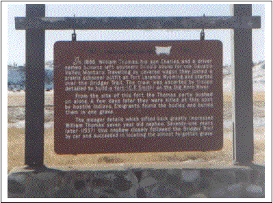 The small Thomas train
traveling with the group became impatient, and decided to rush on ahead just
before the train reached Clarks Fork.
Apparently they were anxious to reach the gold fields. They were attached by
Indians, scalped and killed on 24 August 1866. Members of the Kirkendall train
found the bodies and buried them where they fell. A century later, one of their
descendants, his nephew, located the gravesite, and erected a marker near the
location. The marker is on the north side of I90 at N45º 46.179; W108º
42.864.
The small Thomas train
traveling with the group became impatient, and decided to rush on ahead just
before the train reached Clarks Fork.
Apparently they were anxious to reach the gold fields. They were attached by
Indians, scalped and killed on 24 August 1866. Members of the Kirkendall train
found the bodies and buried them where they fell. A century later, one of their
descendants, his nephew, located the gravesite, and erected a marker near the
location. The marker is on the north side of I90 at N45º 46.179; W108º
42.864.
·
Persons in the train were:
Reverend William K. Thomas (age 36, from Belleville, IL), Charles K. Thomas,
son (age 8), James Schultz (age 35 from Ottawa Co, Canadian West and driver of
the group), and C. K. Wright.
·
·
Here the Norner train joined them. Jim led the trains over
essentially the same route as created by James Sawyers some two weeks earlier.
Jim returned from Gallatin Valley on September 29th, bearing news
that the gold fields had played out, the Crows would remain loyal to the
whites, and that the Sioux were creating a great military alliance to fight the
white men on the Bozeman Trail. On this journey, Col. Carrington assigned Henry
Williams to accompany Jim and compile the survey notes of the route. The
sections from Fort Phil Kearny to Fort C.F. Smith and on to Clarks Fork are
important to help locate the local routes.
Kearny to
Smith (91 miles)
This is the
route laid out by Jim Bridger, and not the John Bozeman Trail established in
1863.
|
Fort
Phil Kearny to Branch of Peno Creek
|
5
miles
|
|
Peno
Creek Branch to crossing at North Bank of Peno Creek (timber & water)
|
7
|
|
To
second crossing of Peno Creek
|
6
|
|
To
crossing at Goose Creek
|
4
|
|
To
Browns Fork of Tongue River (Little Big Horn)
|
13
|
|
To
East Fork of Little Horn River
|
17
|
|
To
Lodge Grass Creek
|
15
|
|
To
Rotten Grass Creek
|
16
|
|
To
Fort CF Smith
|
8
|
·
Along the way back,
Tom Cover, John Richards Jr and Hank Williams accompanied him. Earlier, on
September 17th they stopped at a Crow camp on the Clarks Fork River
where Bridger enlisted the Crows support for the whites. Tom Cover had
accompanied Bridger back to the fort in hopes of getting supply contracts. On
October 1st, Cover & Richards along with some miners, would head
back to Gallatin Valley with a contract for produce.
·
·
The last wagon train
to depart from Fort CF Smith was the Creigh Train, which departed on September
5th.
·
·
October 14, 1866 to December 31, 1866 - Chief Guide at Fort
Phil Kearny,
·
·
On October 23rd,
Bridger, Capt Kinney, 20 soldiers, Lt Bradley & his detachment, Hank
Williams and three miners returned to Fort Phil Kearny. On 6 November Capt
Thomas Breden Burrowes [acting Fort CF Smith Commander] requested of Col
Carrington, that Jim Bridger be sent from Fort Phil Kearny to the Big Horn as
guide and interpreter. Bridger arrived at Fort CF Smith on November 28th,
12 days after the request was received at Fort Phil Kearny. Arriving with him
was 2nd Lt Horatio S. Bingham and 24 enlisted men from the 2nd
Cavalry, and the mail dispatches. This was the last mail delivery for over two
months.
·
·
Bridger returned from
Fort CF Smith directly to Fort Phil Kearny, but date not recorded. He was
onsite by December 6th.
·
·
On December 28th,
a Crow Indian arrived at Fort CF Smith, reporting about the Fetterman
Disaster at Fort Phil Kearny.
The Sioux had attacked Fort Philip Kearney about 12 days
ago. They sent a few men to dash up to the fort and then fall back. Over 100
men followed them out and fell into ambush and were all killed. The Sioux say
there were 113 in all. They had 1500 warriors.
·
·
On December 21st.
Bridger had observed Fetterman change directions contrary to specific orders,
and take a route over Lodge Trail Ridge, that led into an ambush where all were
killed.
·
·
Between August and
October, 15 trains were permitted to travel over the Bozeman Trail; consisting
of 979 men, 32 women and 26 children.
·
·
January 1, 1867 to September 23, 1867 - Chief Guide at Fort
Phil Kearny
·
·
Jim was discharged on
September 23rd.
·
·
It was during this
time, that Col. Bradley was placed in command of Fort C. F. Smith, and Bridger
was there. On May 4th, Bridger dictated a letter to correct errors
that were circulating about the Fetterman Massacre. On the 6th he
received notice from John Richard and three others, that Blackfeet who attacked
them and Tom Cover earlier near the Yellowstone killed John Bozeman. Cover was
wounded and returned to Bozeman City.
·
·
·
On May 26th
the post was attacked. It was reported that over 600 cartridges were used to repel
the attack, and Bradley warns the soldiers that the violator will be shot if he
has any further waste of ammunition.
·
·
May 15 to 22, 1868 - Guide at Fort Laramie
·
·
·
·
May 23, 1868 to July 21, 1868 - Guide at Fort Laramie
·
·
Geological Survey of the Territories - 1871, FV Hayden, US
Geologist
·
·
Hayden surveyed the
Yellowstone area in 1859-1860 with Jim Bridger as guide. He established a dire
need to create a national park. General Nature Act # 16 on March 1, 1872 for
Yellowstone Park introduced initial bills on December 18, 1871 with approval of
the park. Bridgers dream came true.
·
·
Reconnaissance of Northwestern Wyoming - Army Corps of
Engineers, 1873
·
.
·
Captain Jones was
instructed by General EOC Ord to locate a good route from the south, via the
Wind River Valley and Upper Yellowstone into Montana. Following this route
definition created by Captain Jones, the general requested $60,000 from
Congress to open a wagon road from Camp Brown, or some equivalent point on the
Union Pacific Railroad, to Fort Ellis by letter on May 11, 1874. [Note:
Bridger didnt partake of the actual survey]
·
·
Jones identified eight
Old Indian Trails, which were considered important to this activity, in 1873,
throughout the region he explored.
Camp
Brown to Gros Ventres Fork - Trail follows Wind River Valley to its head, then
across the divide to the Snake River and the Gros Ventres Fork. There are
several branches leading off from this juncture:
a)
Jackson Hole
b)
Fort Hall
c)
Yellowstone River and east to Yellowstone Lake (one branch following the Lewis
Fork to the west, and another to the south to Green River, and on to Fort
Bridger)
Camp
Brown to North Fork of Wind River - Trail splits, one going to the headwaters
of the Snake River, the other reaches the headwaters of the Yellowstone River
and down to the lake.
Wind
River Big Bend to Dry Fork - Trail follows along the left bank of the river
to its head. In addition, crosses to the headwaters of Owl Creek, near the
Washakee Needles. This is almost a secret trail, and evidence of hiding places
is numerous.
Camp
Brown to Big Horn Valley - Trail goes north over the Owl Creek Mountains to the
buffalo hunting grounds of the Big Horn and Stinking River Valleys near to
Heart Mountain, and over the divide to the trail leading to Yellowstone Lake.
Wind
River Big Bend to the Sioux Country - Trail travels east along the northern
face of the Sweetwater Valley, by the head of Powder River to the area east of
the Big Horn Valley.
Wind
River Big Bend to Big Horn Valley
Camp
Brown to East Side of Yellowstone Lake - Trail follows to the head of Wind
River, then through Togwotee Pass, north across the drainage area of the Snake
River, and connecting with a trail from the Tetons to the lake.
Wind
River Valley to Green River - Trail traverses across the Wind River Mountains
above Union Peak and on to the headwaters of Green River.
·
·
This new route would
replace the one from Corinne; Utah resulting is greatly improved access to the
lake. In 1873 there were only three approaches evident for the trails: 1) from
the head of Clarks Fork to the East Fork of the Yellowstone; 2) from the head
of North Fork on Stinking River and entering the basin opposite the foot of the
lake; and 3) from the head of the Ishawooa River and entering the basin
opposite the lake headwaters. All are difficult.
·
·
There were only two
routes established into Montana as of 1873 for the transport of products from
the east for the Military and the Indians. The government freighting rates were
identical for both routes. The river route was only opened during the spring
and summer, while the rail route was open year around. Shipment times are
critical, thus the need for improved service.
Missouri
River Route - Supplies are carried by steamboat as far as Fort Benton, and
then distributed by wagons throughout the Territory.
Union
Pacific Railroad - Supplies are carried by rail as far as Corinne, Utah,
then and north by wagons to Idaho and Montana Territories.
·
·
General Sherman
initially did not endorse the suggested new route, but after he traveled it, he
changed his mind and endorsed the road plan on December 10, 1874. The route
allowing also some 2,000,000 acres of farmland to be settled will save over 250
miles of travel.
The information presented
in this site is free to any individual for educational purposes, personal
entertainment or utility. Any other use of the information, including business
or commercial applications is strictly prohibited unless a specific request has
been made and granted by the site host.
