Edwin Martin Newman
Pioneer
Farmer
Monday, May 28, 2012
Forward & Special Acknowledgements
In support of the 100th year anniversary of Billings,
The Department of Parks, Recreation and Public
Lands established plans for the
development of Riverfront Park [Billings
Boulevard and the Yellowstone River]
for use by its citizens. Vern Prill, of the Park
Department, directed the research and eventual determination of land ownership
during its origin. The public report of
findings was compiled by Judy McNally and issued by the Park Department on
November 16, 1981. The original land survey maps prepared by de Lacy, Davis and
Minnie, used in the report may be found in the Bureau of Land Management
offices. Disclosure and research for details about the area were provided by a
group of people who unselfishly gave their time and energy to the project:
o Elmer Bromenshenk
Billings Orson Nickerson Newman
property location
o James & Inez Driscoll S Riverside Drive Ed Newman Property location
o Joe E Miller Nutter
Blvd Courtesy
of Elmer Bromenshenk
o Ethel Sollie Edwin’s Daughter Family Remembrances
o Mrs. Roy
Newman
o William
Newman Scott
o Mrs. D.Celia Willis S Riverside Drive Ed Newman Information
o William M Willis Joseph
Cochran & Ed Newman Information
o John Stricker S Broadway Street Orson Nickerson Newman property
location
o Eliz Stricker S Broadway Street Orson Nickerson Newman property location
o Rick
Halvorson County Assessors Office
o Tom Fraser School Dist #2 Newman School
Information
o Spencer Lauson Ronan Drive Cochran Information
o Mrs. Harold Kinsley Lewis Avenue Cochran Information
o Helene Wallis Clark
Avenue Cochran
Information
o Jim Minnie Surveyor Headed team of
specialists to locate “Josephine Tree” exact placement.
BLM records and genealogical files from the Yellowstone Genealogy Forum
provide additional details and maps.
Ed Newman & the First
School in Billings
Ed Newman was born March 31, 1858 in Croton, MI, and died May 26, 1926 in Billings from Rocky
Mountain spotted fever. [Father was Orson Nickerson Newman, Onida, NY;
mother Elizabeth Metalda Tripp, Quebec,
Canada]
He married Flora Amna Alling
August 1, 1883. She was born February 9, 1856 in Reeds Town,
WI, and died July 21, 1935 in Billings. [Father was Edward Alling, OH; mother Elizabeth
Dean, OH]
 In
spring of 1878 several new families started to move
into Clark’s Fork Valley Bottom. One of
the foremost persons was Orson Nickerson (O. N.) Newman, a former justice of
the peace in Madison
County. He also farmed in
Nebraska, Oregon
& California.
He and his family arrived in March 1878, along with 35 head of cattle, three
yoke of oxen and three teams of horses. [Images of Billings, Carrol
Van West.] Orson constructed a large log house in Lot
#1, Section 16 that became a community center for dances and parties. The
“grand” family home was considered the best in the region. [Caption
recorded in the O. N. Newman Papers at MSU-Bozeman.]
In
spring of 1878 several new families started to move
into Clark’s Fork Valley Bottom. One of
the foremost persons was Orson Nickerson (O. N.) Newman, a former justice of
the peace in Madison
County. He also farmed in
Nebraska, Oregon
& California.
He and his family arrived in March 1878, along with 35 head of cattle, three
yoke of oxen and three teams of horses. [Images of Billings, Carrol
Van West.] Orson constructed a large log house in Lot
#1, Section 16 that became a community center for dances and parties. The
“grand” family home was considered the best in the region. [Caption
recorded in the O. N. Newman Papers at MSU-Bozeman.]
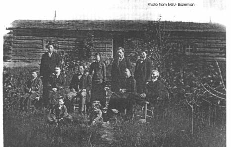
Standing: William Marvin, Mary Amanda, Charles
Henry, and Asa Dow
Seated: Albert Alonzo, Sarah Jane Newman McKinney, Edwin
Martin, Elizabeth Metalda Tripp, and Orson
Nickerson
On Ground: Abe Benton (Pete), and Mark Twain Newman
Ed acquired 120 acres of land (Lots 2 & 3)
in Section 15, Tp 1 S, Rn
26 E in 1883. Date that he took pre-exemption is not available as the BLM
records were lost. He placed a fence around the property soon after arriving
according to the survey notes made by de Lacy in 1878. Arriving with Ed was
Richard W. Clarke. He later made a CASH SALE for his property on Sep 16,
1887. Richard was a dairyman and farmer.
Aaron F. Ford (called Erron) also arrived with the
Newman family in 1878, and lived in a tent on their property for a while. He
lived at 101 S 31st
Street at time of his death on 16 May 1918. Clark later married and had five children.

Before the Newman’s arrived, the location was
used as an Indian campground and burial site. It was their custom to place the
dead in the stump hollow of large tree trunks.
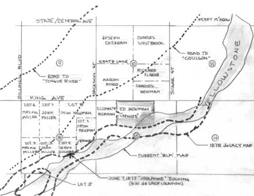
 During
their tenure on the property the Yellowstone
River kept slicing off
pieces of land, and it was reported that Flora said:
“she could hear the bank splashing into the water.” It apparently
took a lot of the land away as indicated by the map. The original river survey
conducted in 1878 is shown dotted, the current position as a solid line.
During
their tenure on the property the Yellowstone
River kept slicing off
pieces of land, and it was reported that Flora said:
“she could hear the bank splashing into the water.” It apparently
took a lot of the land away as indicated by the map. The original river survey
conducted in 1878 is shown dotted, the current position as a solid line.
When the Montana Power Plant was built in Section 2,
additional reconstruction of the river course and banks followed, with the
apparent change in location in Sections 2, 11, 14 & 15. The severe changes
in the river’s course also shows up in Sections 16, 17 and others, is
unexplained. This could be due to survey discrepancies, or actual
reconstruction. Examination of the records relating to differences has not been
researched. A Congressional Act evicted the settlers indicated as living in
Section 16 as of 1877 in 1879. See Cochran
Files for details about the true land ownership in Section 16. Lots 3, 7
& 8 are incorrectly displayed!
The original Ed Newman family home was too small to hold all of the family
members, so the boys slept in a bunkhouse nearby. The original home was later
incorporated into the Driscoll house after they acquired the property.
Jim Taylor, an early valley resident, built a small cabin on the northeast
corner of what later became the Ed Newman land in Section 15. It was reported
that the Indians, whom he apparently had cheated, escorted him out of the area,
leaving the cabin vacant. [The name was reported to be Taylor, and it is presumed that Jim Taylor is
the person being referred.] This cabin served as the first schoolhouse in
the region. Ethyl Newman (Mrs. Sollie), daughter of
Ed and Flora Newman, didn’t attend the school, but was able to identify
its location. It sat next to a foundation located east of 3602 King Avenue South. The foundation
itself originally held another second Newman School.
This one was framed, had one room, and outdoor toilets. There was no playground
equipment. One teacher taught all seven grades. A “big stove in the
middle of the building” heated the school. Attending school were children
from the Cochran, Frady (lived just east of
Newman’s on Lot #1), Miller and Newman
families. Their cabin was ½ mile distant, so the Newman children walked; others
who lived further away rode horses. [The Polk Directories refer to a South Side
School located between 32nd
and 34th Streets. This must be the 2nd wood framed Newman School.]
The first “real” teacher was Flora Amna,
who followed Nat Givens, a farmer who volunteered his time to teach. According
to the Blue Creek School District
files, there were two schools referenced as being on the Newman property. The Newman-Elementary School
at 605 South Billings Blvd,
is the third Newman
School, and is dedicated
to his memory.
Between 1879 and 1910 there were a total of four different
“Newman” Schools in School District #3, north of the Yellowstone River. Each one replaced the former, as
population grew.
[It should be noted that the Josephine location, established by W.W.
de Lacy on his survey map, represents the place where the boat tied up after
reaching the Coulson area on June 7th, 1877 [Piloted by Captain
Grant Marsh], and not the furthest point upstream location where it turned
around on June 7th 1875 [Commanded by Col. Forsythe.] That location
is at Duck Creek. See Josephine
Story in Cochran Files.]
Copyright © 1997, 1998, 1999, 2000, 2001, 2002 All Rights Reserved.
 Email
me:
Email
me:
Katy Hestand
Yellowstone County Coordinator
