|
Yellowstone County History
|
|
One
Hundred Years of Men, Horses & Wagons
|
After William Clarks journey
through the local region there was great anticipation about the wonders and
wealth of the land. In the beginnings, the early surveyors/explorers wrote
about the poorness of the land, and its worthlessness. Soon to change when
wealth of all sorts started to surface; furs, silver, gold, farming and
industrial activities. As the early adventurers stated to inspect the land, they
left trails of their journeys; mostly following age-old paths that were
abounding for a long time before they were traveled by the adventurers. This
segment starts with Manuel Lisa and his first trip into the local land in 1807.
Before he established a foothold into the promising fur trade that would exist
within the region, he enlisted a small group of men to follow him back to where
the L&C Expedition noted an abundance of fur bearing animals, the beaver
the most prominent.
Manuel Lisa & His 1807-1810 Travel Routes
When the L&C expedition returned in 1806, he met with
them and learned about the vast wealth in furs that lay in the northern part of
the Louisiana Purchase near the Three Forks from William
Clark. Manuel Lisa immediately established a trading partnership to garner that
wealth. In April 1807 he first contacted a small group of men interested in
this new opportunity. This was the firm of Lisa, Menard & Morrison,
George Druillard, a
member of the upcoming expedition, was a principle aid to Lisa at the request
of Morrison & Menard, and hired to look after their interests. The partners
were:
Benito Vasquez (2nd
in Command)
John Potts
Peter Weiser (Wiser)
Andrew Henry
William Morrison (Remained in St
Louis)
Pierre Menard (Remained in St
Louis)
In the same year President Jefferson named Merewether Lewis
as Governor of Louisiana
Territory, and William Clark as Brigadier General of the Territorial Militia.
This was quite a promotion, as William Clark was only a 2nd Lt when
he participated in the trek to the Pacific Ocean and
back. The President held his rank in secret, and all thought he was a Captain.
Lisa purchased two keelboats plus $16,000 worth of supplies
and led some of these partners, along with trappers and others (estimated as
being about 50-60 men) up river by boat. The names of engages havent been
located, but some from the L&C Expedition and four actual engages were:
George Drouillard (not engage but
attached to watch interests of investors)
Helped develop relations with Indians & assist
in guiding. In 1808 provided details of the 1807 forts location to William
Clark, who penned a map of the sites location and trail to the Platte River
Spanish settlements.
John Colter (not engage but
attached to assist in developing relations with Indians & and guide duties)
In 1809 returned to St
Louis, sold his land grant from L&C Expedition,
and signed on with Andrew Henry to assist in guiding, etc.) Note: Andrew Henry
was member of Lisas 2nd Fur Trapping Company called the St Louis
Fur Company. During 1808-1809, Colter trapped the area around the Stinking
Water (Shoshoni) River.
John Potts (not engage member of
trapping firm)
On July 6, 1808 at Fort
Raymond, signed a $424.50 note for
trapping supplies along with Peter Weiser and Forest Hancock, to Manuel Lisa.
In 1810 he was at The Fort on the Three Forks with Andrew Henry where he met
Colter. He was killed soon after by Blackfoot Indians. This was when Colter
escaped from same Indians & made his way back to the Big Horn fort. His estate
was then sued by the trapping firm for $1,000.00 for collection of debts owed
for supplies.)
Peter
Weiser (not engage but attached as interested firm member)
In July 1808 was at Fort
Raymond with Potts & Forest
Hancock. Between the years 1808-1810 he was with Andrew Henry at The Fort of
the Three Forks and on Snake River.
Paul
Primeau (engage Joined the group.)
In 1807 borrowed $292.05 for supplies from
Lisa and Drouillard. He repaid debt in 1808.
Antoine
Bissonette (engage)
He deserted along the trip up
river, stealing supplies from the fur trappers, so as to make it easier for him
to return. Lisa sent Drouillard to get him. He was shot, taken back upstream.
Lisa placed him in a boat and sent him down to ST
Louis for treatment. He died Enroute. Later
Drouillard was tried for murder, but cleared by the courts.
..Bouche (engage)
Lazy lout, refused to work on
fort construction.
Forest Hancock
(engage)
The river was especially cruel to him, lots of rushing
water, wind against the direction of travel, and the water was flowing about
four miles per hour; making the journey very difficult. He initially planned to
go to the Three Forks area via the Missouri River where
they would construct a fort (trading post),
trade goods with Indians, as well as do their own trapping so as to eliminate
the most expensive portion of the fur trade costs. $12,649 worth of their supplies was purchased
from G Gillespie & Company of Michilimackinac through a local trader named
Myers Michael. He started out on this venture, lagging about 19 days behind
John Jacob Astors fur brigade that was headed west. He vowed to overtake Astors party. Lisa
passed the Astor party, and continued on, covering 1,200 miles on the rivers in
sixty-one days. He had excursions with Arikaras, Mandans
and Assiniboins before reaching the Yellowstone
River. At the mouth of the Osage
River, Antoine Bissonette, one of Lisas engages, deserted. Lisa
ordered a search for him and commanded that he be
brought back. Drouillard overtook and shot him when he tried to escape
after being caught, wounding him severely. Lisa put the wounded man in a boat
and sent him back to St. Charles,
doing all that was possible for his comfort; but he died on the way. When Lisa
and Drouillard returned the following year, 1808,
Drouillard was tried for murder before J. B. Lucas, presiding judge, and
Auguste Chouteau (associate of Lisas venture in 1809). The jury found him not
guilty.
The main reason was that Bissonette had stolen several packets of food and
supplies from the expedition and stashed them on-shore at various places,
indicating he was planning this escape all along.
En Route, they met John Colter at the mouth of the Platte
River. He was traveling down river
from the Mandan Village.
Lisa invited John to join the group; and he assisted in guiding them into the
region. From there Lisa passed through
the country of the Sioux without trouble, but was stopped by that most
treacherous of the Missouri tribes, the Arikaras. He found between two and three hundred warriors
awaiting his approach, for news always traveled among these Indians faster than
boats ascended the river. They evidently meant trouble, and probably intended
to prevent Lisa's further advance. They fired a volley across his bow at the
place where they had decided that he should land. There was no way to ignore
their imperious command, and Lisa put to shore. Immediately upon touching the
beach he ordered that no Indians should get in his boat, and the chief
stationed a guard to keep off the crowd. The women then appeared with bags of
corn with which to open trade; but an Indian rushed forward and cut the bags
with his knife, whereupon the women took to flight. Whether this was a
premeditated signal for a general onslaught is not clear, but if so, the
purpose was foiled by Lisa's watchfulness and preparation. They had failed to
throw him off his guard. Instantly calling his men to arms and training his two
swivels upon the shore, he gave such evidence of a purpose to
open fire immediately that the Indians retreated in confusion. The chiefs then
came forward holding their pipes before them in token of pacific intentions.
Lisa permitted them to approach and they apologized for the incident,
characteristically throwing the blame of it upon some irresponsible person who
they said was a bad man. Lisa accepted this hollow explanation without being in
the least deceived by it. He quickly finished his business at the villages and
resumed his voyage.
Colter directed them up the Yellowstone,
and not the Missouri as Lisa had
previously planned. Lisa desired to go to the three forks because the L&C
Expedition stated that the location was rich in Beaver and fine furs. They
arrived at the Big Horn and spent one night there before continuing on to Three
Forks, where Lisa planned to build a fort. Apparently Colter convinced Lisa to
abandon his idea to construct a fort at this site, and instead build one at the
Big Horn, where friendly Crows lived.
Note: There is some confusion here: some believe
that Lisa never went to Three Forks at this time, but only stopped at the Big
Horn and constructed the fort immediately. This may or may not be true. Lisas
original intent was to trade with the Blackfeet, and not the Crows.
Returning to (or arriving at) the Big
Horn River
in September they constructed a temporary two-room log fort at the confluence,
completing it (and the fort itself) in October 1807.
The area had an abundance of wood, some coal deposits for heating, and a good
supply of water. Most all the members helped construct the shelter, with the
exception of Bouche, who would not participate, refusing to make pegs for the
roofing timbers. Throughout all the time he was with Lisa, this man was unruly
and considered a slacker, and had left a huge liquor bill for Lisa to pay when
he returned to St Louis. From
Lisas deposition given in St Louis
on May 18, 1811, it appears
that he had his men construct a two-room structure for shelter, and then
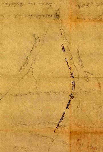
expanded it into a fort. Drouillard made a sketch of the forts location on 5 August 1808 stating it was
established in October 1807. It was located in the angle between the two
rivers (southwest corner). Note that some researchers state it was on the
southeast junction; but that belies the facts. In 1838 MH Stansbury completed a
map of the Oregon Territory,
on which the Bureau of Topographical Engineers were commissioned to define all
of the Trading Posts and Forts connected with the fur trade in that territory.
Lisas post on the Big Horn was clearly denoted as Manuels Fort, and it
rested on the southwest juncture of the two rivers. Richard Oglesby, in his
Manuel Lisa, and the Opening of the Missouri Fur Trade, provided a map that
also shows the fort to be located on the southwest junction of the two rivers.
He called it Fort Raymond.
This is the primary source for that name. He also stated the fort was generally
called Manuels Fort. Chittenden, the
earlier researcher, called it Manuels Fort.
The fort became known much
later under several confusing names: Fort
Raymond, Fort Manuel Lisa, Fort
Manuel, Manuels Fort, Fort
Lisa, Fort
Ramon, or Fort
Remon, with some claims that it was
named after his son Raymond, using Oglesby (1961) as the originator of the name
Fort Raymond.
There are no records of the forts dimensions. The river has shifted upstream,
and all traces of its location have been washed away. Other fort locations on
the east bank have survived.
Colter upon his return to
the Big Horn didnt directly assist in its construction. Lisa asked that he and
George Drouillard locate the
Indians and tell them that he is at the Big Horn confluence and wants to trade.
This is when Colter traveled about 500-1000 miles throughout the southern
regions (Colters Hell and Yellowstone
Park), returning to the fort in the
spring of 1808. Prior to this time the Crows only prepared robes for their
immediate needs, never more. With the demand of trade, each lodge quickly
prepared many extra ones. Drouillard made two trips south into the Big
Horn Basin
area looking for Spanish settlements as well as Indians. George Drewyer
(Drouillard) penned a sketch of the forts location in his logbook, which also
included a trail map to the Spanish Villages on the Platte
that he evidently traveled in search of the Spanish Settlements, some two weeks
distant by horseback. That trail later became known as the Bad Pass Trail by
trappers in the 1830s. This trail led directly south from the fort, passing by
a large sand-stone rock bearing Lisa & Colter names & dates (1807 &
1810) located north of HWY 10 on the west side of the Big Horn River, about ¼
mile south of the old forts location. This map hung in the Bureau of Indian
Affairs offices until January 1925, when it was transferred to the Library of
Congress, and simply labeled Big Horn
River, made by George Drewyer-1808.
This map consists of the
fort location sketch in the southwest angle between the Yellowstone
and the Big Horn
Rivers, plus a page from the
trappers accounts. William Clark is said to have used this map to create an
overall representation of the Indian Country in 1813. Clark
didnt complete his map,
and the Yellowstone regions are omitted. However, the
map sketch was prepared by Drouilllard, and the notations were made by William
Clark.
There is a trail leading
south from the fort, alongside of the west bank of the Big
Horn River
to Spanish settlements located on the North Platte River.
This was noted as being a two-week journey by horseback. This is the Bad Pass
Trail.
Note: Colter left no written record of his
travels, but did tell others of his journey. He traveled with a 30-# pack and
rifle at times getting Indian guides to assist in his trek. His precise route
is unknown, but apparently across the Big
Horn Basin
and upper areas of Wind River.
He was the first white man reported to visit Jackson
Hole. He climbed Teton
Pass
enroute to Pierres
Hole. Some of the other men in Lisas party went to Three Forks in the fall of
1808, but found the Blackfeet very resistant. In the spring of 1809 Benito
Vasquez closed the fort and with Colter and the others they headed for the Mandan
villages on the Missouri.
With them they had 15 beaver skins and 10 buffalo robes. They arrived there on 22 September 1809.
Lisa running up-river with a new supply of provisions and 150 men in 15
keelboats met them. George Drouillard was with them.
Lisa left the Big Horn fort
in July 1808 and traveled to St Louis
where he established the St Louis Missouri Fur Company.
First Location Notice of Lisas 1807 Fort. (See Trails Records)
Cleve Kimmel
Referenced documents that contain
current copy rights cannot be copied and submitted in their entirety only
granted excerpts. No file that is downloaded to a recipient can be utilized in
multiple-mailing lists; or for a fee or profit. Files downloaded are for the
expressed usage by the recipient in pursuit of historical information or
genealogical background.