|
Yellowstone County History
|
|
The postal routes and mail delivery system within Montana
were established by the Postmaster General in Washington
City (eg., DC). He generally took
advice from the Territorial Delegates and Governors regarding where routes are
needed. Mail delivery was essentially picked up and delivered to a postal
location, such as a town or army post. Individuals went to those locations for
their mail; and the postal offices were generally combined with an existing
business; saloon, store and the like. When steamboats proved to be effective in
transportation within Montana,
the Postmaster General ordered that mail shall be delivered in the following
sequence between points: 1) by steam steamboat or train, and then; 2) by
stagecoach. With the land mass so very wide-spread in Montana,
this allowed for some unique delivery systems and opportunities for fraud in
the mail contracts. There were no Yellowstone
County specific mail delivery
systems in the early days, as all were linked as part of another over-all
delivery contracting system. General mail delivery essentially started after
1863; prior to that the mail between military forts was handled by army
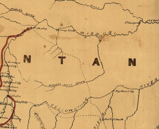
couriers. The Postal Service map of service for the United
States in 1867 (ED Boyd mf000055.sid)
shows delivery in the local area being delivered to Fort CF Smith over the Bozeman
Road and Hazen Trail. Mail delivery to Big
Horn City
is noted; but no route indicated. Hazen Trail is a spur that connects Fort
Benton with Fort CF Smith. The
Bozeman Trail (Road) connects Fort Kearney, NB
with Virginia City. Not shown on this map are secondary
roads (wagon roads) connecting Fort CF Smith with Big
Horn City
and Sullys Point on the Powder River. These roads are
on the west and south sides of the Big Horn and Yellowstone
Rivers. It continues to Fort
Keogh. (Identified by Walter DeLacy
in 1864-5 on ct001859.jp2) Concurrently with these postal roads, there existed
a trail/road on the north side of the Yellowstone
River connecting Bozeman
with Fort Union
(later passing through Fort Keogh
and Miles City).
This was known after 1877 as the Tongue River Road
(going east), or the Bozeman Road
(going west). This later route had many controversial issues with the local
residents, the postal delivery operators and the Postmaster General.
Hazen Trail Route
This trail (road) was created by General Hazen in 1866 after
a visit to Fort Phil Kearney. Fort CF Smiths site was about to be located by
Jim Bridger when the General arrived at Fort Phil Kearny and took a small group
of soldiers along to provide protection and to show the way to Fort Benton. It
is believed that Jim
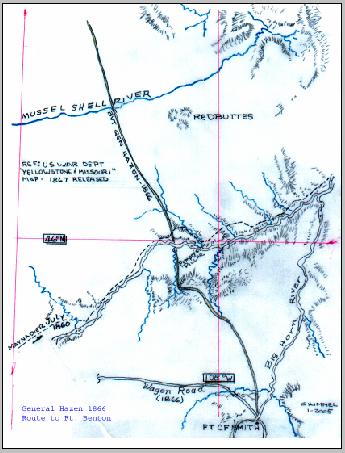
Bridger most likely gave the route description to the group
before departing; as he was very familiar with that region of Montana.
Most of the route is on private land today, and used in-part by the ranchers
for their use. The segment leaving Fort CF Smith follows the John Bozeman route
for a short distance, then cuts north and crosses the Yellowstone
River below Pompeys Pillar.
Portions of the route near the Yellowstone
River today are only passable by
foot. Land erosion has created deep channels in the earth; and these sections
of the route havent been used for many decades. At the river crossing there
were some rings set into the banks, apparently used for drawing a ferry
across during high water. [These artifacts havent been located nor verified.]
This Postal Mail Contract hasnt been researched nor
located.
Yellowstone Stage Line
This line was established soon after Fort
Keogh and Miles
City were established. This route
followed the survey made by Lt Maynadier in 1860. In existence for over a
decade prior to this time, the Wells Fargo stage/postal lines from Fort
Benton to Fort Hall were in
constant operation. They established a new standard for mail delivery. Although
they called themselves a stage line, one apparently had to be connected in
order to gain access to the coaches that were usually filled with mail. They
ran a tight and honest operation concentrating upon the timely delivery of
mail. Way stations and horse feed lots were spread about 20 miles apart. All of
their animals were grain fed, and could easily outrun the grass-fed horses of
the Indians. They used six horses on the flat lands, and eight on the hilly
areas. From the various reports these horses loved their job, and really
desired the running aspect. Although
Wells Fargo has published some great books about their
stages, the best review can be obtained from Carrie Adell Strahorns Fifteen
Thousand Miles by Stage, Two-Volume Diary, pub 1911. The Yellowstone
Stage line originated in Helena and went south to Bozeman,
then eastward to Miles City.
The mail contract was held by the Salsburys etal. [Mail Contract not yet researched]
According to the postal rules, there can be no over-lapping of mail delivery
contracted routes. Thus this line must have picked up and delivered mail at one
of the Wells Fargo postal stops between Helena
and Bozeman. [Transfer location needs
to be established, along with the contract number and issuance date.] This was
an honest postal route. There were two humors incidents that occurred on this
line:
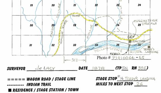
1) After 1877 the line delivered mail and passengers to Terrys Landing (a
local name). This location was opposite of Cantonment Terry, which was
constructed by the military for transportation and storage of army supplies
delivered by riverboats, and was located slightly to the west of that place.
Later it was renamed Junction City. A swing ferry was in operation by saloon
owners, Brown & Davis in 1878, and that ferry was soon replaced by a better
style. Mail wasnt delivered to Terrys Landing until the townsfolk petitioned
for service. Prior to that, mail was delivered to Pompeys Pillar (to the
west), and Pease Bottom (to the east.) John C Guy operated a small PO
& stage stop in Pease Bottom where he had 160 acres of farm land. This was
eight miles from Junction City. Junction
City had no PO facility at the
time, so some folks stole Johns PO. It was returned
under a threat of a federal offense.
2) In 1879 the Postal Service established a mail route from
Rock Springs, WY (junction point with the
Union Pacific RR) connecting with John C Guys PO, now
called Eschetah. This route connected with the military forts north of Rock
Springs, Fort
Custer, and the Eschetah, the
terminus. This now meant that mail was being delivered in parallel between Junction
City and Eschetah, a direct violation of the law.
Besides that, the mail arriving at Junction City
from the Rock Springs line was being
sorted at that PO, and Junction
City wasnt a legal postal stop for that line. This
and several other fraudulent lines caused the Postmaster General to be removed
from office. The next mail delivery stop on the Yellowstone Stage line heading
east was restricted to Froze to Death Station (26-miles distant). None of the
mail arriving at Junction City from
the south was to be off-loaded or sorted there, as this wasnt a designated
stop.
South Hills, Yellowstone County and Crow Reservation Postal Service
As homesteaders arrived, and permanent residences were
created, numerous
mail routes were established throughout the region. These local areas were
virtually riddled with trails that criss-crossed each other. Postal boxes
and home delivery was started. A few of the many post offices are recorded on
some topo maps.
The delivery routes and addition of all the others is a work in progress.
These are planned to be added when the initial route contracts for each are
located. Mail service in South Hills is
partially defined in Tales and Trails, by Birdie
Street and Monica Weldon.
Cleve Kimmel (Montana_cal@hughes.net)
Original Release
Date: January 1, 2010.
Referenced documents that contain
current copy rights cannot be copied and submitted in their entirety only
granted excerpts. No file that is downloaded to a recipient can be utilized in
multiple-mailing lists; or for a fee or profit. Files downloaded are for the
expressed usage by the recipient in pursuit of historical information or
genealogical background.