|
Yellowstone County History
|
|
(1875 to Present)
NPR moves away from Congressional Members management, and
Frederick Billings was named Managing Director, through which started the
beginning of NPR as a private enterprise. The line would come out its financial
slump, and completion was in sight. The track route through Montana still hadnt been decided, although
most mapping projects showed the track essentially following the
extensive1871-1873 route surveys. It was pure conjecture on the residents as to
where it might be. No one was caught more unawares than the residents of
Coulson. They had presumed that their wee town would be a major shipping point.
However, the managing directors of the line had other ideas, and made plans to
capture a wider market share of travel/freighting than was originally conceived
in 1864. Anxious settlers (squatters formally called pre-emptive settlers)
started entering the southern regions of the Yellowstone Valley
areas. Wagon trains started to arrive from both the east and the west. The Fisk
Trains were predominant in eastern travel, and followed the NPR survey routes
from Minnesota
westward. Wagon trains from Salt Lake City went to the Missouri River, then up
to Bismarck, and the across the land to the Yellowstone River. Thomas McGirl, in
early 1877 established a trading post at what is now called Huntley, and people
were starting to populate the Coulson area. Perry McAdow constructed a sturdy
ferry for transporting people and wagons across the Yellowstone
just north of where NPR would in 1882 construct their bridge. To garner more
trade for McGirl, he placed a directional sign for travelers from the east that
directed them his river crossing. When arriving there the hopeful people
discovered that his ferry was merely a few planks tied together. Many of the
travelers were headed for the gold fields in the west, but a few stayed on. As
the valley area started to fill with settlers (all before the land surveys)
NPRs management team realized that a great opportunity existed for them, and
they had to act fast to take advantage of the influx of farmers and ranchers. The
original land grant was still linked to the northern route, although they had
been surveying a southern route through Montana Territory.
Apparently no one re-linked it to the new route, and the grant land was only
being applied when the centerline of the track was surveyed as per the original
grant. As a result, there was a great deal more in-lieu land to be exchanged
than originally conceived, so the corridor was opened up to 60-miles on each
side of the track. The Indian reservations lands were essentially excluded,
making for an even greater demand on the exchanges. This opened up a great
advantage to NPR as they swapped the corridor lands lost to settlers and
mineral rights for forest land in the northwest.
1876-1877 Congressional & NPR Actions
The Supreme Court considered the earlier NPR breaches of original
land grant specification requirements, and ruled in favor of the new management
team, which does not require NPR to return corridor land to the GLO! General
Custer, who guarded the NPR construction & surveys for several years, was
killed in 1876 at the Little Big Horn, and with the suppression of the Sioux
Nation, a heavy influx of settlers started. Dr. Hough convinces Congress to
fund money for examination of timber use, and successfully establishes the National
Forest Service. NPRs previously bad treatment of workers, under the
thumb of President Charles Wright Barstow, erupts in riots, and was called:
The Year of Violence. Dissention was rampant among the workers and
construction was at a virtual standstill.
1878-1880 NPR Actions & Land Surveys
Charles Barstow finally initiated Frederick Billings operational
plan and construction re-started after the riots were stopped. Frederick
Billings ousted Barstow
and became President on May 24, 1879. The line from Bismarck extended 100-miles to the west, and
the land grant corridor finally caught up with the railroads line. Many
homesteaders were caught up in battles for entitlement of their homesteads; and
in most all cases lost their land to NPRs corridor claims. Homesteaders
continued flowing into the grant land areas in ever increasing numbers, and recently
created Indian boundary changes precipitated a need to re-examine the rail route
which currently directed the line to be on the west side of the Yellowstone
River from Glendive Creek south. Adna Anderson, (Chief Engineer 1879-1880), decided
to see if better RR Track location existed in the Yellowstone
area, where many of the settlers were putting down roots.
Settlers filled the local area in 1875-1878, mainly
concentrating into separate areas: Columbus, Park City,
Canyon Creek, Coulson, and Huntley. Walter W. DeLacy, surveyed the land
sections centering about the Prime Meridian. In May-June of 1877 McGirl settled
in Huntley and started a trading post. He contracted the Coulson Line to
deliver some merchandise to him. Captain Grant Marsh delivered the supplies to
him at the end of May, picked up some furs to carry back, and then continued
upstream to where Joseph MV Cochran had settled (Riverfront Park).
Perry McAdow had acquired his Desert
Land directly across from
Belle Butte (Sacrifice Cliff), but hadnt as of yet moved any belongings onto
the land. Only Cochrans tent was erected. Neither man was in the area when the
steamer arrived. This is when Captain Marsh carved June 7, 1877 into a
cottonwood tree that was a few yards distant from Cochrans tent. A marker is
erected in the park to commemorate the event. This date has no relationship to
Captain Marshs earlier trip upstream to Duck Creek on June 7th
1875. Seems that the two dates are always getting mixed up! By 1878, the GLO
had blocked off the odd-numbered sections of land north of the Yellowstone River from new homesteading. Many of the
persons who were squatting (pre-emptive) on the NPR land were evicted, simply
left, or in other ways removed. John Dover, a later resident on the Yellowstone River
north of Billings,
successfully defended his claim against NPR (MMLIC) land grant claim. It took
several years of fighting to clear the title.
NPR 1879 -1889 Construction Loans
Frederick Billings
initiates a series of financial plans during this time period to garner construction
loans by mortgaging the corridor land (which was now entitled directly to NPR,
along with all rights prior to formal survey). The initial listings of finances
are noted below, NPR received a lot of money during the next decade of
operations: (Details of the transactions are available in YGF Files regarding
Title Abstracts)
§Farmers Loan and Trust Company, Trustee (May 1, 1879 Filed Vol 2, Land
Grant Records, pg 255)
§Conveyed $2,500,000.00 for the main line of the railroad (Missouri Division) in Dakota and Montana
§Central Trust Company of New
York, Trustee (January 1, 1881 Filed Vol 2, Land
Grant Records, pg 31)
§Conveyed $43,393,000.00 (Construction costs not to exceed $25,000.00
per mile) for main line and Cascade branch, telegraph line and all lands.
§Farmers Loan and Trust Company, Trustee (November 30, 1883 2nd
Mortgage)
§Conveyed $20,000,000.00 subject to prior liens, except for lands
situated in Minnesota and Dakota east of Missouri River.
§Farmers Loan and Trust Company, Trustee (December 1, 1887 General 2nd Mortgage)
§Conveyed $12,000,000.00 subject to prior liens, except for lands east
of Missouri River in Minnesota
and Dakota.
§Farmers Loan and Trust Company, Trustee (December 2, 1889
Consolidated Mortgage)
§Secured $62,442,000 or an amount not to exceed $160,000,000, except for
lands previously granted to NPR by Congress, and except for lands in Minnesota and Dakota east of Missouri
River. The General 1st Mortgage, General 2nd and General 3rd
Mortgage were considered prior liens.
NPRs Plan to Create Billings Townsite
NPRs Chief Engineer, Adna Anderson, establishes an
engineering/survey team in 1880 (headquartered
at Cabin Creek on the Yellowstone) to secretly place track south of
Yellowstone River & issues grading contract in November 1880 after he
reviews the site plans. The team consisted of:
Henry Ward Rowley (age 22) hired
April 1879 by NPR for engineering services
Jules Breuchard hired spring 1880
(Alphonse Fteleys step-son)
Fred Foster hired 1879 (Robert
Fosters son.) Robert is co-founded of Fosters Sub-division w/Kurtz
SP Panton (previously employed by
NPR)
NPR Cook not identified
Billings Secretly Created 1880
The townsite of Billings appears to follow the same pattern as used earlier
by the Union Pacific when the town of Caldwell,
ID was established.
A great deal of secrecy was needed to prevent others from gaining
insider-trading knowledge. The Surveyor General of Montana
had initiated a land survey of the eastern parts of Montana,
starting with the Yellowstone
Valley areas in 1878.
These surveys continued on for several years. Settlers homesteads apparently were
placed into box portions of land to represent their holdings near as possible
to the actual survey grids without overlapping the section lines. This survey
was formally platted by the GLO survey office and plat books, then these plats,
along with the registers were issued to Montanas
land office at Bozeman
in the spring of 1879. (Actual date seems to be elusive; but the records
indicate that Perry McAdow filed in March.) These original plats, along with
the attendant homesteaders names and locations, are stored in the BLM office
at Billings.
The homesteaders, who were caught up in the struggle for land ownership with
NPR or the prevailing rules for ownership, such as Joseph MV Cochran, do not
appear in these platted records. Those people are listed and filed in separate
entries. Refer to earlier discussions about homesteads. There are various tales
about how Billings
was selected; but Rowley gets the nod; others are conjectures, including Fred
Fosters later interpretation.
Rowley received new survey plat map
copies from the GLO in 1879 before the team was created. He examined the
territory and located overlapping odd-numbered sections on the Prime Meridian
(near Coulson), and this looked like a good site for a city. It also was the center
of various roads leading in and out of the area. Coulson was there, but not
incorporated as such. The land east (south) of the Yellowstone River
was also found by the team to be an excellent route for the railroad, and obviously
more so than the central route surveyed in 1872-1873.
John Issaei NPR engineer who was
headquartered in Miles Citys home office, created a plat of the proposed
site of Billings
in November 1880 for Rowley. He also selects a lot for his future use, but
later discovers its on marshy land. After having made his selection, he was
allowed to change the site.
Rowley shows the plat plan created
by the team to the NPR management in Minnesota
& [apparently] was directed to file the plat with the Secretary of
Interior in DC. On Jan 1, 1881 it was reportedly filed as Sec 33 Tp 1N,
R26E, & Sec 3, Tp 1S, R26E). Co-existing with the filing were all
companion water rights, ditches, etc., extracted from NPRs land grant. [Note:
there are no separate fillings of RIGHTS for the town, area, ditches or related
accesses and activities. None were needed.
Using the platted concept, NPR
offers business lots to banks & investors in the east, and investors in Europe. About 400 lots were sold to them before offering
such to local residents.
.
MT population was clearly not to be informed
of the Billings
site.
Billings
Secretly Created - 1881
Col Pike (NPR Manager) had SF Panton (an NPR engineer)
create a Stadia map of the planned Billings
site in September.
The Plat map showed detailed city
lots, and it integrated with Coulson. This was created in NPRs St Pauls offices. (The Plat
has not been located)
The Stadia Map & city lot-plat
maps were first presented to investors in MN for business opportunities. Many
lots were acquired.
Coulson
Town plat was filed in October by John
Alderson in hopes of getting his wee town selected as the NPR shipping point
for Montana.
This effort had no effect upon the decision to create Billings.
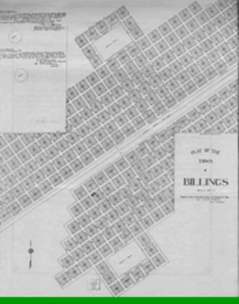
Billings
Townsite Survey
The City center was established by two monument markers; one
being at the center of 25th Street North and Montana Avenue, the other on 25th
Street South and the south edge of First Street South. Theodore F. Branch
was the surveyor who attested to the location. Future residents knocked the
markers down as they were in their way! These survey marker locations are denoted on some of the Sanborn Fire
Maps.
Creation of Minnesota
& Montana Land & Improvement Company
1882, March 23 Articles of Incorporation
Realizing that a great opportunity existed, Heman Clark,
John B. Westbrook and Thomas C. Kurtz
created the Minnesota and Montana Land and Improvement Company [called the
Company, MMLIC] in Ramsey County, Minnesota*. This firm became effective as of
March 15, 1882, and continued for thirty years. Release of incorporation was withheld
until March 26, 1896. It was originally filed in Minnesota, with capital stock of $200,000, of
which, $100,000 directed for indebtedness liability
*Filed in the State of Minnesota, Book G,
Incorporations, on pages 111-113. Re-recorded in Montana
Territory, Book B, Incorporations, and
Certificate of Transcript from James H. Mills, filed with the Secretary of the
State of Montana.
All filings accomplished much later on March 26, 1896. Apparently they tried
hiding their true identity and intent.
MMLIC
Garners Land
Acquisition
On April 1, 1882, NPR sold
29,394.22 acres of prime land in Clarks Fork
Valley west of the future site of Billings to MMLIC. MMLIC
paid $113,558.86 for the land which amounted to: $3.86/acre. Plans were already
underway to irrigate the soil.
Certified Billings
Plat Map
A series of filings were initiated,
the first was reportedly filed January 1, 1881with the Secretary of Interior in
Washington City. (This filing hasnt been located).
It was apparently part of the original plan for secrecy. On June 1, 1882 a copy
was filed in Custer County, followed by a filing on September 1, 1884 in
Yellowstone County and then refilled on June 3, 1909 in Yellowstone County (eg.,
2nd Filing.) Dont know why? However, at this time, Coulson was
fully integrated into the Billings
City plat.
MMLIC formally Meets with Coulson People
Heman Clark arrived in Coulson in
April, 1882 & spoke to residents about creation of Billings
& their irrigation plans for the entire Yellowstone
Valley area around Billings. This was a shock to them, as they
all expected that Coulson would be the town to exceed all others. Heman proposed
locating three booms for water extraction from the Yellowstone River, each placed about ten miles apart; Coulson,
Laurel, Park City, plus at each extraction point placement of a sawmill would
be established. Concurrently with this announcement, Clark
released an order for several million bricks to be used in construction of the NPR
hotel, roundhouse, machine shop and other buildings needed for their operation
and to benefit the residents.
NPR Missouri
Bridge-Sketch at Bismarck
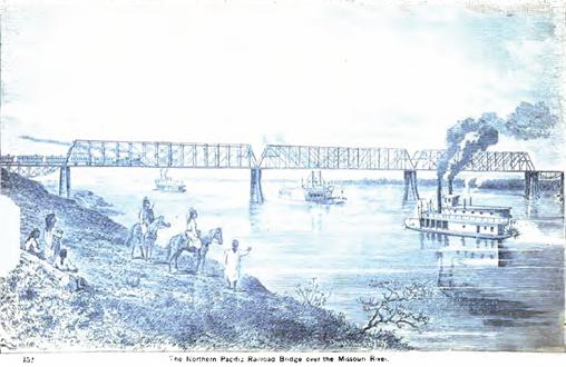
Note: for three
years, NPR didnt have financial resources to construct this bridge, and during
the ensuing winter months they laid track across the river. During the
intervening years, the foundation supports are virtually located as they were
attesting to superb engineering.
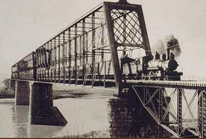
NPR Missouri
Bridge after
Construction
NPR Big Horn Bridge
& Tunnel
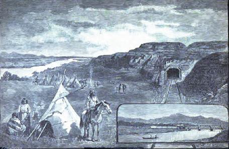
This tunnel still exists, and can
be viewed today. It is about 1,100 feet in length. Before 1925, NPR created a
bypass around the cliffs (to the left of the tunnel location), closing down the
site. The insert shows a sketch of the original bridge across the Big Horn
River. In the 1920s NPR
relocated the bridge a short distance to the north, and elevated the road bed
by about ten feet. This was to provide clearance for flooding potential during
the winter months, should the Big Horn be blocked with ice floes. During this
later construction earth was moved from locations near the Yellowstone,
and used for fill. This created some marshy areas, still visible today. On this
site was the original location of the Manuel Lisa Yellowstone Fort, constructed
in 1807, for trading with the local Indian tribes. There currently is a fishing
access & small park to honor the event.
NPR Yellowstone
Bridge - 1882
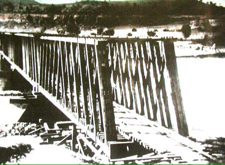
This is an early wooden
construction photo of the bridge. At the upper right, is Perry McAdows ferry
he built. John Shook operated it.
NPR Roundhouse
1909 in Billings
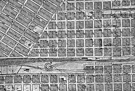
c1886 through c1947
(34th Street
& alongside the NPR Tracks), are now long gone. During winter months
in the 1930s, NPR cleared their rail tracks with steam. The map section shown
above also defines the incorporation of Coulson into Billings. (City of Billings, Engineers
1909)
MMLIC Actions April 14, 1882
The Coulson Post reported that
Heman Clark was planning to start construction of the first irrigation ditch in
June, and that it would be completed within a month. It was to be tied into
Perry McAdows desert lands irrigation ditch for water & power use in Billings. This took
place, and was used for supplying water and electricity. It wasnt the Big
Ditch.
A colony of 450 residents from
Ripon, WI were expected to arrive and take up land at the western end of the
settlement, and MMLIC made an offer to fence, break their land, build each
settler a home and furnish them with either 100 head of sheep or cattle.
As a result of the advertising and
the rich-irrigated farmland had people coming so rapidly and in such great
numbers that by April 22 MMLIC was swamped satisfying potential buyers.
Billings Townsite Company
On March 20, 1883, NPR conveyed the
Billings Site (Section 3-1S-26E and Section 33-1N26E) to a newly formed
townsite company created by MMLIC within its shell and named it the Billings
Townsite Company to manage sales. Heman Clark was appointed president and managed all the land sales & related business
operations therein.
Billings
Power Plant Built 1886
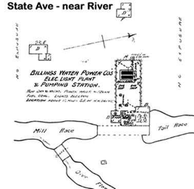
Water was extracted
from the Yellowstone about where Bitter Creek
enters. This was the approximate start of the rapids that existed until the
1920s. The rapid was called Hellgate, Hell Roaring, or Ramseys. It had a 13-
foot drop before leaving Section 2 (Perry McAdows homestead). This location is
near the future site of Josephine Park. Excess water exited from the Tail Race
ditch. The equipment in the building is identified on the Sanborn Fire Map.
Some of the water mains leading to Billings
were constructed of wood, and are identified on the Sanborn maps..
Henry Ward Rowley - Engineer
Henry Ward Rowley was born 1 October 1858 in Newport, Oneida
County, NY, son of
Nelson Burr Rowley (NY) and Abigail Coffin (NY). He lived there until age nine,
when his parents moved to Minnesota and
settled into the Farmington area, near St. Paul. There he
attended the public schools, and later attended and graduated with an
engineering degree from the Minnesota
University. At age 22, in
1879, he was employed by the Northern Pacific Railroad to assist in the
construction of line passing through the Dakota Territory.
He quickly rose to the position of Chief Engineer and for two years
successfully managed the construction of the line. Seeing an opportunity for
great personal achievement, he left the railroad in the spring of 1882 to
become an engineer for the newly formed Minnesota and Montana Land and
Improvement Company MMLIC), which established the townsite of Billings while
controlling nearly all the land in the valley west of Billings. He had a
remarkably successful life while still less than 30 years of age. He was a
civic leader, owner of important real estate, and engineer of some of the most
extensive irrigation projects in the area, a banker, city official, school
trustee, sportsman and social leader. He possessed a strong personality,
gracious and aristocratic bearing, and when he stepped off in Billings he immediately became one of its
leading citizens. The building of Billings
was not by accident or happen chance, but by well managed design.
In 1876
the general land surveys for the local region had finally reached Clarks Fork Valley
(Yellowstone County area), and a plat map for future
homesteaders was created. This early plat was made available to the settlers by
April 1877 [March?][3][1].
When the Indian wars were essentially concluded in 1878, the Northern Pacific
Railroad started to lay track after a few years delay. The railroad was placed
under closely guarded financial controls, and construction cost was limited to
$25,000 per mile. At that time, when Rowley was in charge, the planned route
was clearly established and shown to be from Bismarck essentially due west to
the Yellowstone River, crossing the river near Miles City, and following the
river on the north side into the west leading towards Fort Benton. Rowley
started to examine the route again, or else it was pointed out to him, that it
might be better if they stayed on the east side of the river, and crossed in
the Clarks Fork valley area, just north of the rim bluffs bordering both sides
of the river (Belle Butte Sacrifice Cliff). The roadbed appeared to be
equally flat from previous detailed surveys, but in doing so he realized that
it would give him an opportunity to establish a town and freighting center of
significant size at the river where there were two adjoining odd-numbered
sections of land that centered about the recently completed Montana Prime Survey
Meridian. What happened next is partially conjectured, but mostly fact. Henry
examined the land soon after joining the railroad, finding that he could indeed
place a town there. This would be a major undertaking, and it would be
necessary to keep the concept and location secret until he was ready to make
the announcement. He presented his plan to the railroads financial eastern
bankers, and it was probably the best news they had received ever since
construction began. It looked like a sure winner. To make this work three
things would be required: 1) The land plat or its counterpart would be created
in secrecy at Miles City, and presented to the banks soon as possible, probably
in late 1880, and they would remain silent about the transaction. 2) A director
would be needed to manage the creation of the town, sell lots, advertise and
otherwise manage the whole activity. For this, Rowley would step down as Chief
Engineer and take over the operation at the appropriate time. Thus was formed
the Minnesota and Montana
Land and Development Company,
established in Minnesota. 3) Financial backing for the town creation
would be needed, and additional land had to be acquired in secrecy so that its
ultimate purpose of providing potential financial growth to his companions
would go undetected. To accomplish this Rowley apparently solicited Frederick
Billings as the major financial backer, Austin North
and close friend Fred H. Foster to acquire additional land to be made available
for town expansion. Fred
Foster, being young and without resources, solicited his parents, Robert
& Lucinda (creators of Fosters Addition) to bankroll the activity. Their
trade of real estate and transfer of property rights were uniquely accomplished
before construction started. There are no written documents describing the
actual insiders activity effort, but the facts disclosed in property title
transfers of both North and Foster confirm the action. The land acquisitions
simply could not have been a random chance of good luck. When the Billings land area
officially went on sale, many persons who were first in line expecting to
receive choice lots felt cheated when they discovered that these were already
sold to eastern investors and others. Before 1881 had ended, many of the towns
lots were already sold or committed, and the residents of Coulson who were
hoping to make an investment harvest were never really in the financial loop,
and that town subsequently vanished. The first land plat for the city was
created in Miles Citys
NPR offices, and publicly filed in Minnesota.
Frederick Billings graciously offered to accept the naming of the town after
him. Austin and Robert helped secure the
open land to the west before the general public was made aware of the towns
identity and the revised route of the rail track. [Details of some
transactions are noted in the Foster and North bios files.]
On May 8, 1883 he married his schoolmate, Harriet Maria
Meeker, in Billings.
Harriets parents were: Lewis Meeker (NY), and Marion Welsh (NY). Harriet was
born September 26, 1860 in Fort Ann, NY, and died in Billings
June 26, 1943. One of the major undertakings was to construct sufficient water
supply to the town and local area. This was known as the Big
Ditch. In 1885 he organized the Billings Water Power Company, and conducted
the initial work to construct the improved water works and electric plant
centered in the former town of Coulson.
He was the electric plant manager until its sale in 1908. In 1915 the
waterworks were sold to the city. To start the electric system he initially
procured a large crane with a shovel and dug a canal leading from the Yellowstone River northward for about two miles to
the plants location on Perry McAdows land (Josephine Park area). The canals
headrace was 70 feet wide and 15 feet deep (depicted on the 1903 Billings City map). At
the end of the race way he had a pond, and placed a large float about 30 feet
square onto it, and placed a coal-fired steam engine there to run a dynamo
turbine to produce electricity. Soon afterwards he merged his interests with AL
Babcock and Herman Mund and constructed a brick pump house on the site. In this
new housing
structure he placed the equipment needed to produce both water and
electricity for the city. All trenches for the various ditches had to be dug by
hand[4][2].
He was also a
promoter and organizer of the Billings
Land and Irrigation
Company. He held interests in the Northern Hotel, Mercantile National Bank, and
other interests in both Montana and Seattle. He held large
parcels of land within the area, and was associated with the development of the
Sugar Factory, Chamber of Commerce, the Street Car Company, Civic Club, and
Country Club. He was a major influence in getting important civic projects
accomplished.
[5][1] Perry
McAdow filed on March 8, 1877.
[6][2] Along the Zimmerman Trail, 1977 by Charles Zimmerman
Billings Water Power Company
From 1882 c1885 residents had
water delivered from the Yellowstone
River by a water cart or
barrels, sometimes they complained about the fish that were in their drinking
water. Construction of the first Water-Power Plant was completed in 1886 (the ditch
headwaters was in SE Sec 2S-Rn26E). Rowley managed the plant until 1909 when
Yegen Construction Company built a new facility on he former Coulson site.
MMLIC
Land Acquisition
Actions
1883, March 20 Warranty Deed
& Release for Land that Created City of Billings from NPR & Central Trust Company
to the Company from Range 26E. All of Section 3, T1S and all of Section
33, T1N [1,102.25 acres] less a 400-foot wide strip of easement for the NPR
railway & telegraph was sold to MMLIC for $40,000. This was in accordance
with the original intent to construct a town on the premises as identified in a
January 1, 1881 filing with the Secretary of the Interior in Washington DC[1].
[1] Recorded in Volume A, page 4, Filed May 17, 1883, Commissioner of Deeds for
Montana Territory, NY
NPR
Forest Land
Sales (Recap)
NPR established four of the largest
lumber mills in the nation through sales of some of their timbered land in the
northwest; all with no restrictions for foreign sales or logging permits. In 1923 the Grant Land sales reach $100,000,000.
The current sale of timber is approximately $2 Billion annually.
§1887
ST Paul
& Tacoma Lumber Co (Hill & Weyerhaeuser) - 80,000 acres in WA
§1890
Weyerhaeuser 212,722 acres in MN
§1899
Weyerhaeuser 900,000 acres in WA
§1907
Anaconda Copper 1,000,000 acres in MT; sold 670,000 acres to Champion which
were resold to Plum Creek in 1993.
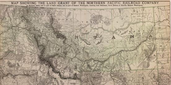
NPR 1883 Completed Route in Montana
After the rail was
completed, four section maps were created that depicted the actual route &
the deeded land grant townships containing odd-sections of land owned by them: Minnesota, North Dakota,
Montana, and Washington. These were released much later,
but are the only ones depicting the final details. (Map pictured is
ct001237.jp2, published 1890). (ND is rr002760.sid, 1892 & 3131001.sid
1895), (OR-WA 5392001.sid, 1888). MN N/A.
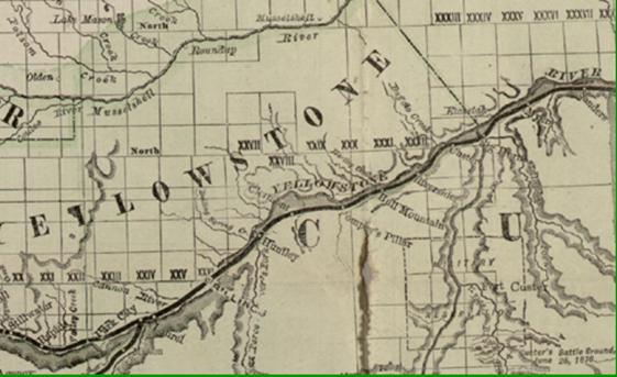
NPR 1883 Final Meridian-Guide Allotments (Billings Area Land)
The bulk of the
corridor land is located north of the river. Each square represents a township
of land, 36-sections, 18 of which belong to NPR. For the land grant areas, NPR
created a series of plat maps depicting the ownerships of settlers. They
resemble the GLO maps in style, held in the BLM files at Billings. These maps are virtually
non-existent today, with only one of the local area north of the rims having
been located. The shaded area extends about 55-60 miles north of the track.
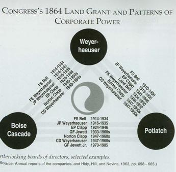
Creation of Lumber Giants
The three largest
corporations have over-lapping board of directorships. That provides for strong
control over the production of wood products and the harvesting of longs.
Primarily these firms remove all vegetation from their allotted sections
(clear-cutting).
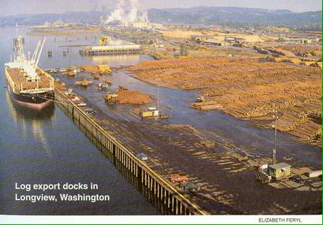
Your Typical Log Shipments
Logs waiting for
shipment to the far east.
[Thanks for Watching]
Cleve Kimmel
(Montana_cal@hughes.net)
Original Release
Date: January 1, 2010.
Referenced documents that contain
current copy rights cannot be copied and submitted in their entirety only
granted excerpts. No file that is downloaded to a recipient can be utilized in
multiple-mailing lists; or for a fee or profit. Files downloaded are for the
expressed usage by the recipient in pursuit of historical information or
genealogical background.