|
|
Out in the Boonies #7 |
|
Pompeys Pillar |
By Dave Dodge |
|
|
|

|
Rock Saturday, January 01, 2005 |
|
|
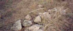
Rock
Cairns (sometimes called monuments) are scattered throughout the Pryor Basin
& South Hills areas in pre-Yellowstone County [1] . Sheepherders
created many in the 1900’s to assist them in establishing a landmark for
their particular local territory of herd management when leases were
permitted for grazing. This trek considers only the ones created for use by
travelers for route directions or land ownership markers, although one is
reported to perhaps be a sheepherder’s cairn. Most of the |
|
|
Staging area – Twin Monuments (Dave Trek #2) 2 Hours & critical to the understanding of the region. 1.
Trail Section #1 – Cottonwood Trail Cutoff & Road to 2. Trail Section #2 – Trek to McCormick’s Trail (Monument Trail) 1 to 3 hours 3. Trail Section #3 – McCormick’s Hill Descent to Pryor Creek (Monument Trail) 2-4 hours 4. Trail Section #4 – Bozeman Trail (Sawyer’s 1866 Trail) 3-5 hours |
|
|
These segments can be separately taken. But due to the elusive nature of the routes it is suggested that careful planning of the routes be observed before starting. Experienced personnel have traversed the routes many times over decades, and still missed the landmarks noted in this trek. Please be patient and very observant. Once you see your first rock cairn, all the others will POP into view, as if by magic. The ones located on the southern side of the Pryor’s (other treks) will then become clearly evident. |
|
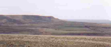
Trek #7 – Pryor Gap to Monument Peak-WYThis Trek considers
only portions of the trail currently contained within the 1851 Crow Indian
Reservation boundary. There are four sections of it being platted for
viewing. The old Indian trails and wagon roads where the rock |
|
|
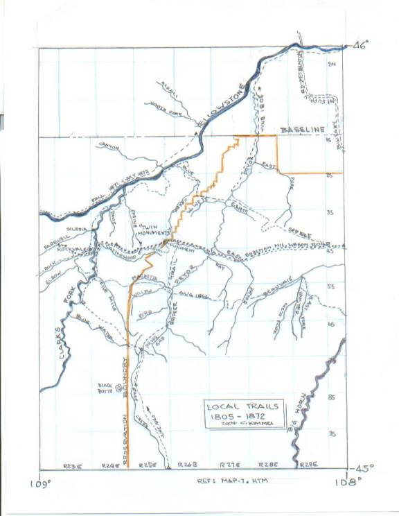
The original area trail
passing through the Pryor valley has several names, depending where and when
one was traveling at the time: Teepee Trail, Mee-Tse-Tee Trail, Bridger
Trail, Bridger Trail Cutoff, Sawyer’s Trail, Bozeman Trail, Bozeman Military
Supply Trail, Monument Trail, McCormick’s Trail or Hogs-Back Trail, The Montana Territorial
Maps, created initially by Walter W. deLacy, and then followed by the ones
created by the State’s Survey General’s Office from 1866 through 1873, made
gross estimates of where the major landmarks that existed in the eastern
portion of the state were located. The mountains, streams and rivers were
askew to their true location by several miles, leaving a general impression
of where these landmarks were actually located. This seems to be incredible,
since by this time the Corps of Engineers had produced numerous maps showing
their true locations. Some of the maps were generated as part of NPR’s survey
searches for possible routes, others from explorations, surveys and reconnaissances
by the military. Why none of these maps were used to plot the eastern portion
of the territory prior to the time when the survey general would make an
official report hasn’t been explained. Lt. Maynandier & Captain Raynolds,
with Jim Bridger as chief guide, created the best cohesive map for The latitude locations appear to be placed at the same relative locations as current maps. The longitudes are typically plotted late (to the west of their true position) by approximately one-second of arc. This translates to a 1-1/2 mile west of true position error. However, for the local area, this error is consistent, and thus the mileage definitions between recognized points are true. Yellowstone Kelly,
during his campaigning with General Miles and others prior to 1870, traveled
the local areas with a great deal of frequency, although he personally took
great pains to keep off the Indian Trails and other such type of roads. This
he did to increase his survivability. But he knew where most all of the
trails were located, and the names of many streams and mountain passes that
weren’t noted on the Maynandier Map. He copied the map, and added numerous
attributes that were missing and their names [2] . The Montana
National Guard picked up the original map, as it was prepared while Kelly was
on the military payroll, and was supposed to be placed on display (2004.) A
full-scale copy is available for viewing by contacting the Webmaster. The
Monument Trail, discussed in this trek, is noted, and is listed as a “ The The name came about
from the Indian practice of shooting arrows at “Arrow Rock”, a large rock
formation in the gap, which resembles an arrowhead. It was meant to be a
sacrifice to the god-like “Little People” who were supposed to be dwelling in
the rock. [Pryor Creek was called Arrow Creek; the Pryor’s was In 1807, John Colter, who
was a member of the Lewis & Clark Expedition, obtained his release from
the group when they were on the return trip through the Pryor area. During
the winter of 1807-1808, he passed southward through the gap, and onward
towards the During the intervening
years, the Pryor-South Hills areas became a haven for the Fur Companies. The
smaller trapping groups were competing against the American Fur Company, and
traveled the areas between In 1831 Jim Bridger was
guide for Jeremiah Smith’s fur hunting expedition going from the Powder River
area back to their After the beaver fur
trade deteriorated, the Gap became a haven for freight haulers, with the main
route being between |
|
|
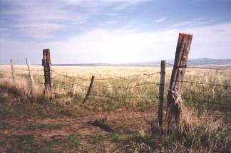
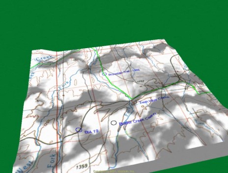
Staging Area at Twin Monuments (South Hills) |
|
|
|
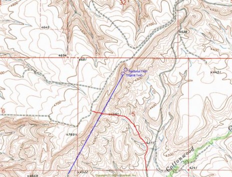
Bring a GPS, food and
water, map & compass, and then travel to the site location (map &
travel directions are provided in Trek # 2.) From here
use your compass or GPS to locate north. The landmasses are very deceiving to
the eye, and most visitors orient themselves about 45 to 90 degrees off from
north. Current TOPO and road maps do not accurately show the trails or roads
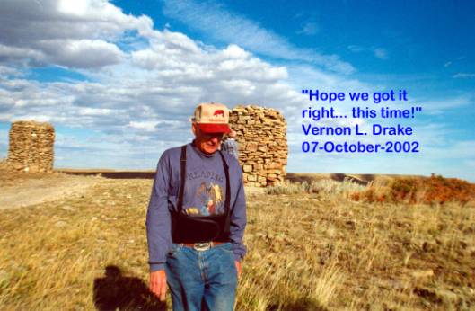
where the two cairns are located. Pictured here is Vernon Drake after
completion of the second reconstruction effort he fostered for one of the
vandalized |
|
Permission to visit this site, located on private land, has been granted. The access road runs alongside of a fence line, but when you are at the monuments, you can see the wagon ruts that run alongside of the fence. The fence was added when the current owners relocated their property lines for improved farming operations. |
|
|
History of the Twin Monuments |
|
|
|
The
actual builders haven’t been identified by name, although there is much
conjecture. According to the numerous original land survey records about the
area, there is no mention of these structures. Accordingly, they had to have
been a more recent addition, probably after 1915. William Doss first
homesteaded the land, on which the monuments sit, in the early 1900’s, and
city records indicate he arrived there between 1915 and 1916. He received his
Land Patent on December 5, 1921 [8] . His brother
Samuel homesteaded on the property to the east. However, the monuments
are located directly on the mid section line extension of T3S, R25E, Section
32 [homesteaded by Christener Dix on the west, and Walter Dix on the east];
and positioned near the East-West Township Boundary line. The original survey
conducted by Carl Gleeson on August 14, 1903, provided no indication of their
existence. Neither did the survey conducted by Otis Ross, Oct 29, 1913 or
others in the same time frames. They mark the original crossroads to the
Pryor Gap, Clark’s |
|
building
of the |
|
|
Before continuing to Section 1 of the trek, locate the ½” diameter bore sight in the southernmost cairn (See Driving Instructions – Dave 2), and see where it is pointed. There was a rock cairn located on Stratford Hill, prior to Robert Stratford’s homestead, and it sat alongside of Monument Trail. This is where Section 2 of this trek continues. Please
pause at the site for a moment, look around, and reflect upon the enormous
amount of effort that Since the South Hills’
rims are slightly south of the Township 3 South line, it seems probable that
the Dix brothers placed the markers there to separate their two properties,
not realizing that they missed their actual boundary line by a few feet.
Their name “DIX” could be construed to mean two, thus the construction of the
two GPS Location – approximate centerline of the monuments: 45° 31’ 20.44” W 108° 39’ 43.45” N. |
|
|
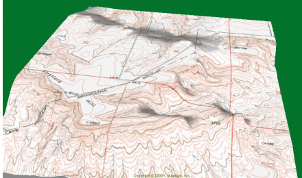
Trail Section #1 – Cottonwood Trail – “Hogs Back Trail Cutoff to Cottonwood Trail” |
|
|
|
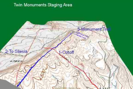
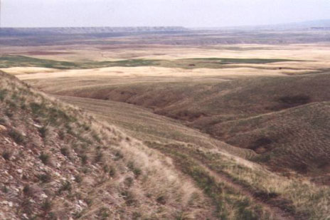
This
wagon trail (1-Cutoff in RED) passing just below the Section 5 centerline,
connects the original Cottonwood Trail with the 2-Silesia Road (e.g., Ranch
Road on private property.) 3-Monument Trail joins the other two and goes
eastward towards the highest point in Yellowstone County. The dashed roadway
near the right edge of the picture is the current track of |
|
lore indicates that the freighters hauling supplies to their campsites below would go down loaded, but would come up the hill at another place, probably Bird Hill [just west of Stratford Hill] that was the terminus for the original Cottonwood Trail. There are two other locations to access the valley floor from this general vicinity. The Monument Trail & Road to Silesia were used by Perry McAdow to haul supplies to Fort CF Smith, by Jim Bridger when he guided emigrant wagons through Pryor (Pass) Gap and on towards Virginia City, and when he was guiding military contingents to Fort CF Smith. The road follows the edge of the South Hills rims, and mostly consists of a rocky sandstone substrate. It can be used in wet weather without danger of getting stuck. Being on top of the rims edge also provided good visibility so as to avoid potential Indian attacks during the early troubled times. Later the pathways were used by a considerable number of freighter wagons. It is most likely that the ruts one can see throughout the area were created by these huge and heavy wagons. Many thousands of trips were conducted into the Pryor area to support the military needs and the grazing supply needs of millions of animals. When one finds wagon ruts that appear to be on the Bozeman Trail, in all probability they are the remnants of these freighters passage. |
|
|
|
|
|
|
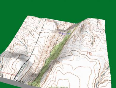
At the
Twin monuments, take a sighting SW at a 30° angle [the same angle on which
the monuments are constructed] and follow it until you can see into the
valley floor. About 3.2 miles distant, at the 4100-foot level in Section 19NW
is another rock cairn perched on the northwest slope of the canyon wall
[identified in blue]. It is located on private land, and was there before
homesteading took place. It is very difficult to locate, and requires a lot
of patience, a steady hand and a good pair of binoculars. There is another
cairn, located midway between the two end points, at the 4200-foot level, on
the south edge of a canyon wall on BLM land in Section 7SE that blocks its
view from the rims. It is slightly offset to the west of the 30-degree line
of sight. Pieces of old freighter trails exist that follow the |
|
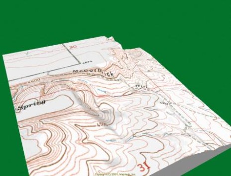
Trail Section #2 – Trail to McCormick’s Hill (e.g. Monument Trail) |
|
|
|
Sections
of the original trail leading eastward from the Twin Monuments entrance gate
are not evident since the roads have been relocated. Follow the |
|
Just
before reaching the towers, on the right is a small dirt access trail (road)
leading to a fence line. This is continuation of the Monument Trail.
Permission to cross is required, so please pass this portion. The trail is
still partially visible, but the years of wagon travel over the rocky terrain
can still be discerned. Virtually the entire route passes within a few feet
of the cliff’s edges. When the |
|
|
Large pieces of broken sandstone are gathered and mark each turn of the trail, and additionally the edge of the trail has rocks scattered alongside of it leading to Stratford Hill. According to the landowners, these were there when the land was acquired. The farmers did not place them there. These are partially buried into the rocky soil, and are mostly covered with moss. It appears as though they were previously upright, but have fallen down over the years. According |
|
|
to some of the Crow Indian ranchers, this trail was marked with a lot of rocks (monuments.) The trail is narrow, but apparently with a purpose: on the south the hillside drops off and is dangerous to travel; on the north the soil is almost devoid of rocks, making it impassable during wet weather. The stones must have been placed so as to make sure the traveler will arrive safely. |
|
|
|
This section shows the trail
passing along the south edge of the hills, and onto the Reservation land. The
cutoff trail leading to GPS Location: 45° 31’ 9.13” N: 108° 35’ 51.86” W
|
|
Return
to |
|
|
Trail Section #3 – McCormick’s Hill Descent to Pryor Creek (Monument Trail) |
|
|
|
This section of the trail [dashed double lines] descends from the hillside located in Section 30, T3S R26E. The access gate (2002) is shown below. |
|
|
|
|
|
The trail goes for about 100 yards, and then starts its descent into the valley floor. The private road is really only wide enough for a high clearance 4-wheel drive vehicle, but during fire emergencies, the large fire truck, operated by the Blue Creek Fire Department, has been known to traverse the road. Quite naturally, when partway down it has also been stuck! Before the road was cut into the upper edge of the rims, it is believed that the freighters traversed directly up the gentle slope of the hill. |
|
|
|
|
There are six fence lines that have to be crossed when descending through the dry land farming & grazing areas. Local residents reported that the end of the trail [Pryor Creek] used to have a rock cairn placed there to denote the location of the trail. The trail continues on the south side of Pryor Creek, following the Hay Creek passageway and onto Fort CF Smith by following portions of he old Teepee Trail. When the trail reaches the NE corner of Section 31 [halfway to Pryor Creek] it branches two ways: east to Pryor Creek [Monument Trail}, and south to Pryor Gap [Passing through Four-Corners] located between Sections 18 & 19. This southern cutoff is probably part of the Bridger Trail. |
|
|
There are several smaller trails scattered throughout the Reservation, and these tend to obscure the original routes. Freighters and landowners throughout the last century created most of the added trails. The south route through four corners is on private land until it reaches Hwy 19. At the juncture of four corners, located on a southern branch of Fourth of July Creek is another cairn, perched upon a rocky ledge. It has been standing as long as the residents can recall from early times. This cairn is about six-feet high, and 3-feet in diameter at the base. The Crow Indians formed various types of rock piles that are associated with Tribal Warfare during the mid-1880’s. These were markers for fallen warriors or enemies, noteworthy feats, battlegrounds, shrines and hero’s monuments. They were scattered across the county for many years until the land they rested upon was plowed. Access to the ones on the north side of Pryor Gap cannot be seen. Most of these monuments are considered sacred; so their precise locations or pictures are not provided. Some of the more noteworthy ones are [9] :
|
|
|
|
|
Trail Section #4 – Bozeman Trail [Sawyer’s 1866 Trail] |
|
|
After
reaching Hwy 19, drive east until you reach Pryor. Starting at the east edge of
town, there will be mile markers placed alongside. Use these to assist in
locating the |
|
|
|
The first cairn is located about 1/2-mile to the southeast of Hwy 19 at route marker 19 + ½ mile. It is difficult to see and is called Buster Creek Cairn. It is located on the east slope of a small hillside on East Buster Creek. The Bozeman Trail goes due north at this point following the east bank of the creek bed, and to the northeast of the cairn in Section 16 by about one mile. Hwy 19 & the Bozeman Trail are not the same at this location. [Photo – Trails & Tales, current access requires permission.] Just past Hwy marker
20, on the right are the |
|
|
|
|
They are located on the Raferty Ranch property. Reportedly created by the Crow Indians, the tops originally had a slightly offset arrangement of flat stones giving them the appearance of crouching wolves. They are reported to be a territorial tribal marker, the meaning of which has been lost. However, they are directly on the Bozeman Trail pathway, and since they are on the down-slope of a small hill, this would indicate it might also be a route marker for the Teepee Trail. Early travelers on the emigrant trains reported none of these monuments alongside Hwy 19 AS BEING IN EXISTENCE, or else they were not seen by them, which would have been virtually impossible; so all must have been created after the area was settled, and subsequently created for used as land territory markers for a lessee (sheepherder) or owner. Continuing east on BIA 19, at approximately 22-1/2 miles, on the right are large that appear to have been placed there by some unknown entity. These rock formations are well described by some of the wagon train diarists as they passed through the region. |
|
|
[1] Information about the trails is extracted from the various reports in the Yellowstone County history. [2] Refer to Yellowstone Kelly, Luther S. Kelly, published 1926. Book contains a reduced size copy of the map. [3]
Compiled Statistics from
Rick, and Susie Graetz. “Crow Country”. [4]
Interpretative Plan for
the [5]
Reported in “A General
Historical Survey of the [6]
Wasden, “From Beaver to
Oil.” Reported in “A General Historical Survey of the [7] Pierre Chouteau recommended that Captain William F
Raynolds engage Bridger as a guide to explore the [9]
From the Heart of Crow
Country, by Joseph Medicine Crow; and Lt. Bradley, Journal of the [10] The trail marker rings are made of loose stone, partially buried into the soil, with a grouping of other stones located in the direction where one is to go. Normally some object on the horizon, to which you can plan on raching for the next leg of the journey. They are typically placed so that there is a clear line-of-sight. |
|
|
|
|
![]() Email
me:
Email
me:
Katy Hestand
Yellowstone County Coordinator