|
The Twin Monuments
and Local Trails
There were two rock- cairns (Monuments) set
on the north edge of the South Hills’ rim rock areas overlooking
Monument Creek in Section 5, Township 4 South, and Range 25 East. They are
called “Twin Monuments”, and several pictures have been displayed
in the Billings Gazette over a span of about 80 years. William Doss first
homesteaded this land in the early 1900’s, and city records indicate he
arrived here between 1915 and 1916. He received his Land Patent on December
5, 1921 [1] . His
brother Samuel homesteaded on the property to the east. They are
located directly on the mid section line extension of T3 S, R25 E, Section
32; approximately 160 feet south of the Township boundary line. The survey
conducted by Carl Gleeson August 14, 1903, provided no indication of their
existence. Neither did the survey conducted byOtis Ross, Oct 29, 1913. The
northernmost Cairn was vandalized as more homesteaders entered the plateau
area, with some pieces apparently used in building foundations, others taken
just for curiosity.
|
|
Vernon Drake authored
the interest and development of the article presented herein. He is also
responsible for the reconstruction of the vandalized Cairn,
using old photographs as the guide. Note the structural retaining ring of
large rocks placed about halfway to the top. Several of these pieces weigh
over 300 pounds.
The monument is visible
for over ten miles from the south, east and west directions from sites where
old trails existed. It appears that from the out lying trails one could see
where to travel to get up onto the South Hills plateau, and then into the Yellowstone River
bottom (Clarks Fork Valley.)
Construction of the Twin monuments do not fit the pattern that was so evident
for other types of Cairns,
especially those conical ones made by sheepherders to mark their territory
range borders.
In October 2000, a
group of experienced masonry craftsmen and engineers reconstructed the
vandalized cairn, but it collapsed soon after. This established the theory
that sheepherders couldn’t have created them, since the structural
design is tougher to master than originally thought. It would appear that the
mass of the stone has to be directed toward the centerline of the cairn to
prevent outward collapse, as evidenced by the first reconstruction failure.
The cairn was rebuilt, using old photographs as a guide, in the summer of
2002.
There were several cairns
in the viewing vicinity, all about seven to ten miles distant, and apparently
served some purpose during the early 1900’s. In examining the placement
of these Twin Monuments, one can establish for a fact that they are at the
center of a series of trails. Why there were two has not been determined, nor
has who or when they were constructed been determined. They are positioned
about 40 feet apart, and at a true angle of N-42 degrees W. [Compass
bearing is about 30 degrees.] This alignment is not coincidental with the
summer or winter solstice angles of the sun. There location doesn’t
appear to coincide with any of the early territorial boundaries from the
French, English or Spanish acquisitions.
However, there is a close resemblance to the Crow Indian Boundary
interpretation resulting from their loss of 1,100,000 acres of land to public
domain in 1878-1879. The Director of Geological Survey, on 10 June 1896
signed a treaty with the River Crows establishing permission to survey their
lands and establish boundary markers in accordance with the same practice
utilized in the rest of the land. Stone monuments or posts placed at the
corners were the preferred method. The Indians were left with a central piece
of land (Crow Indian Reservation) that was bordered on the west by a ridge of
rimmed rocks that bordered by what is presently referred to as “the
South Hills” area of Billings. The government (GLO-BLM) surveyed the
strip of land between the reservation line and the Yellowstone River,
and established corner markers for the sections and quarter sections; plus
they identified specific landmarks. Later, in the 1900’s they entered
the reservation land, and completed the surveys for the area. For the
Indians, their land now ended at the ridge of the rim rocks bordering the
South Hills west of Pryor Creek. The last edged rimmed area is at the site
occupied by the Twin monuments, and their angular placement parallels the
reservation line plotted by the surveyors, but located in the valley floor 1
½ mile further to the southwest. It is conjectured, that when Paul McCormick
established his grazing rights for100, 000 head of sheep on the reservation,
along with brother Frank who also had contracts for supplies on the
reservation and at Fort Custer, he might have ordered construction of the Twin Monuments,
and the numerous others that have been vandalized along Monument Creek, and
the ridgelines nearby. His son, Paul, was manager for the road and tunnel
construction operations that occurred between 1900 and 1905. His road crews
would have been well capable of constructing a rock cairn that would
withstand the harsh Montana
elements, and that could be used as a marker for his lease-land holdings.
Additionally, he traded extensively with the Indians, was granted permission
to construct roads through their lands, and he transported great amounts of
fresh produce, seed, and meat supplies to both the men that were tending his
sheep, and the reservation Indians themselves. For that purpose he would need
a series of roads that provided the easiest access from his home base in Billings, and the
outlying communities within his vast route. He had the largest freighting
outfit in Montana
and it would make sense to have visual markers created to indicate where to
travel during winter days, when the roads are not visible; and to mark the
territorial limits of the Crow Reservation as seen by the Indians at that
time.
One amazing feature of the cairn, lying adjacent to the rim’s
edge (southernmost one) is that there is a “line of sight” hole,
approximately one-half inch in diameter, constructed in the formation. It
aims directly to the high point of land at the
tip of the South Hills where the USGS High Point
in Yellowstone County [2] ,
elevation marker is located [4971 feet]. This is also on the Monument Trail
Line leading across the south boundary of the area, which is marked by many
stones and small cairns, placed along the route that leads to where Red Eye
Smith’s Saloon was located, and to where the descent and ascent to the
plateau was established on the McCormick land. The trail descending from the
monuments themselves, was called “Hogs Back” by early settlers,
and appears to have been part of the same road that continues on past
Bridger. This could very well have been part of the Original Bridger
Trail, as denoted on the 1867 Montana
Survey Map. Refer to the trail links shown in this report for details.
It is also probable that the monuments were created by the Story-McAdow
Freighters or other freighter operators when they traveled on the Military Bozeman Road [3] between the Yellowstone
and Big Horn. There is no mention of these monuments in any of the early
survey field notes. They do indicate water sources for stock is available at
the site, and access routes were created for cattle and other livestock to
reach the water. These monuments are halfway between water sources available
from the rivers.
It is reported that the monuments were actually constructed by
ranchers in the area, who had sheep holdings in the land below.
Or perhaps they were constructed to establish directions to Red Eye
Smith’s Saloon, collection point for freighters supporting the
Burlington-Quincy railroad, located at the top of McCormick Hill on Monument
Trail.
The USGS maintains a vast collection of Territory, State and
International Boundary Marker files, but do not have any pictures of these cairns. Their design
has been observed to be very similar to several others created by the USGS
between 1900 and 1905 to mark boundary lines under their jurisdiction, but
none were recorded on film, but eyewitnesses recall their appearance. The key
element in the design is the incorporation of the structural band of
reinforcing large stones placed about four feet up. These retain the
structural load within the column, and not allow the forces to be exerted
outward, which would lead to their collapse. Unfortunately, no written record
of the Monuments has been located. These should be considered for Historical
Preservation as a National Archival item when their history has been
satisfactorily identified.
|
|
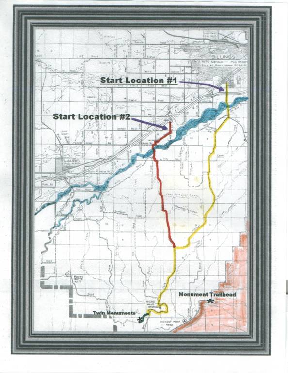 Start Location #1 – Hillcrest Road
Access (Yellow Accented Road) Start Location #1 – Hillcrest Road
Access (Yellow Accented Road)
Take the South Billings Blvd
road south across the Yellowstone
River. It changes name
to “Blue Creek Road”
shortly after crossing the river. [Note: Blue Creek Road continues on to Pryor Creek Road.]
After crossing “Blue Creek”, a small stream that is usually
devoid of water, turn southwest and continue on Hillcrest for about ten
miles. Where it joins onto “Duck
Creek Road.” From there follow the
direction noted in Start Location #2 below.
Note: At about five
miles from the departure of Blue
Creek Road, you will come to a “Y”
near the top of the hill that is very deceiving. On the right is
Hanser’s Salvage yard, and that road is called “Keller Road.”
Hillcrest continues to the left, and changes to a “rough” gravel
road.
Start
Location #2 – Duck Creek
Road Access (Red Accented Road)
Take the “Duck Creek Road”
south across the Duck
Creek Bridge,
being sure to keep on the east side of the creek. Continue south on the road
until it joins with Hillcrest
Road entering in from the east.
[Note: The river area
just east of the Duck
Creek Bridge
is where the steamer Josephine, commanded by Col. Forsythe on June 7th,
1875, terminated his journey upriver. The river channels were of different
composition then, and further travel was near impractical.]
Continue south on Duck Creek Road
(yellow accent), passing by the radio towers. The road then will have a
gradual descent into the valley, and then rise up to the plateau and start a
sharp turn southward. At this point, on the right will be a barbed wire fence
and cattle gate. The gate is about 30 feet in length, with a release clamp on
the left side post. Please close the gate after entering and leaving. At this
point you will be entering private land, of which permission to travel over
to visit the monuments has been granted. [Contact the Webmaster for details
of ownerships.]
The monuments are not
visible from this point. The road crosses the face of the South Hills Cliffs,
and is about one-half mile in distance from the monuments.
Monument
Trailhead Location
The access start of the
trail is off Collier Road
as indicated. The entire trail is on private land, and access must be
obtained from landowners before entering. Here Red Eye Smith’s Saloon
was located. This is also the Paul McCormick Trail, and the Trail used by
Perry McAdow & Nelson Story when they had a supply contract with Fort C.
F. Smith in 1867 & 1868. The Twin
Monuments and the
Monument Trailhead connect with each other by following the South Hills
Ridgeline “Monument Trail” road across the edge of the cliffs. This
entire trail is on private land, and access permission must be obtained
before entering.
|