|
1-
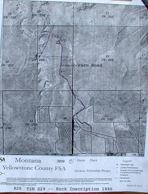
Inscription Rock Location
|
|
The formations to follow (before moving o to State Land) are located in a 320-acre
portion of land being transferred as noted. Much of the land usage in this
region has deteriorated from continual un-controlled expansion of Prairie
Dogs. A local farm road is used to reach the site as marked.
This portion of the road required 4-wheel drive and
about 2-3 mph top speed.
You can Google Earth the site to gain a better composite
view of these coordinates. This site is about two miles north of the 1874
Excursion stop.
|
|
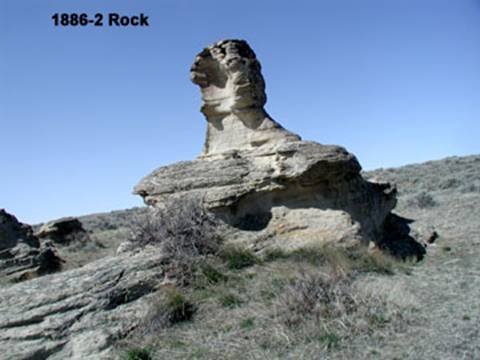
2-The rock
in question looks like this….
|
|
The rock stands about 15-feet high, and the
inscriptions are located within the bowl-shaped interior. There are three
other rocks in this cluster – but this is the only one that has
carvings.
As normal, the carvings are basically block letters.
The stone is extremely hard, and it must have been a real chore to even put
a dent into the surface.
|
|
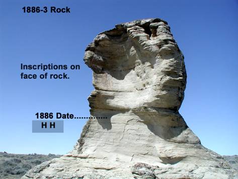
3-Rock Face
Composite
(Upper and
Lower)
|
|
Initial and date carvings are created within the two
bowl shapes (upper and lower half).
|
|
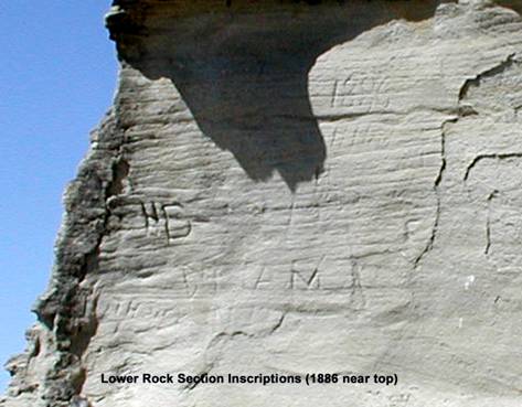
4- Lower
Face
|
|
The 1886 date followed by HH below is in the upper
corner. The other carvings are difficult to read; but the HD might be John
Henry Dover, as he sometimes went by Henry. HH person hasn’t been
identified.
Note that major flaking of the surface has eliminated
a large portion of the surface. Although this appears to be a soft-flaky
substrate – it is very strongly attached to the stone face!
|
|
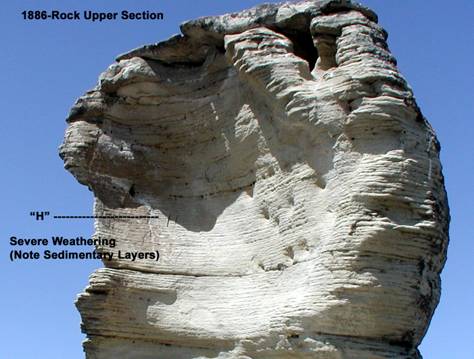
5-Upper
Face
|
|
The prevailing winds attack the rock opposite of the
image shown here; and probably created the cupping shown over a very long
time of erosion. Only the deeply carved H is clearly visible; and most of
the layered covering shell is lost.
The sedimentary layers are clearly visible in this
image. All the rock formations throughout this region exhibit the same
degree of layering; only the shapes change.
|
|
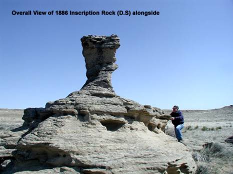
6-View from
the back-side.
|
|
The full size in noticeable in this photo with the
land-owner standing alongside. Please note that the majority of the land
area is relatively FLAT!
One can only wonder how this and the other outcroppings
were created – and why?
|
|
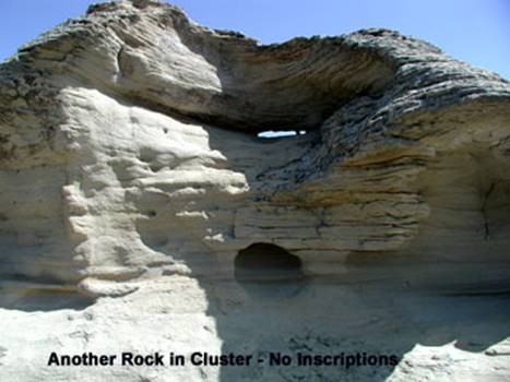
7-Nearby
Rock Formation
|
|
This interesting rock is right next to the one above,
but no inscriptions. Again, it looks soft – but alas, it’s hard
as a rock (pun).
It is about eight feet high.
|
|
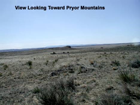
8-View of Pryor Mountains
|
|
From these rock formations the Pryor Mountains
(snow-capped in the distance) are clearly visible. Note the lack of vegetation.
From here we will be traveling southwest over private
land to the 1874 stopping point at their camp site located currently on
State Land and home of the Teepee rock formations.
|
|
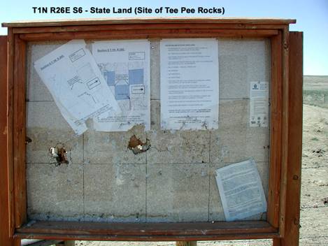
9-Map of
the Teepee formation Locations
|
|
This land site is restricted to foot traffic only
& is available for view.
You can enlarge the image to read about the access
& restrictions. The trail runs along side of the ranch-land next to a
fence.
Entering from here is a ‘single person-access’
gate and you are about one mile from the Teepee rocks (dogs are welcome to
accompany you). There are numerous rock mounds that resemble Teepees in the
area: and the largest grouping photos of the rocks near the center of the
land are not published here. Refer to Don Weibert’s book for a detailed
image provided by Mrs. A C Stohr.
|
|
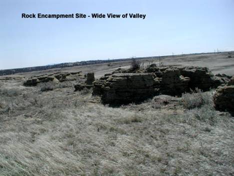
10-Rock
Encampment of 1874 Explorer’s
|
|
These rock out-croppings are about 4-5 feet high, and
about 100-feet long. They are at the perimeter edge of a slight hillside
that overlooks the valley floor and offers excellent protection from
potential attacks. None occurred here during the explorer’s trek; but
residual evidence shows that they spent some time here.
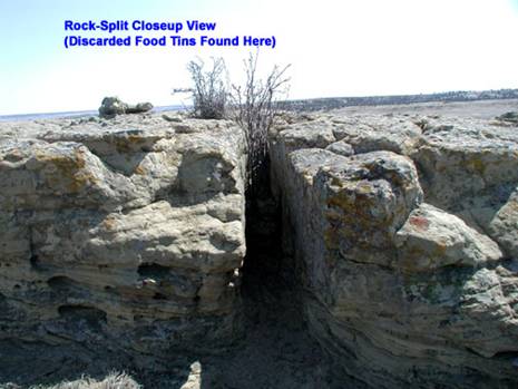
The larger rock in the foreground is split in two,
and has a gap about 10-inches wide running the full length. Several decades
ago, one of the newly born calves, which happened to be blind in one eye,
mistakenly entered the crack in search of some ‘tasty green grass’,
and became wedged tight! In its frantic attempt to pass through it
scratched up numerous tin cans and other trappings from the soft sandy soil
underneath. When the rancher discovered the dead body, he also found the
numerous artifacts that were unearthed. The tin cans were of the type manufactured
prior to 1870; as they had their ends sealed with lead. It was then
apparent that the explorers must have spent some time at this safe haven
during their route to Tongue River.
This route is about five miles west of the
Yellowstone Stage Road that was in service from 1877 until replaced by
other transportaion.
|
|
11-Closeup
view of the split in the rock
|
|
This was were the canned food tins were discovered.
|
|
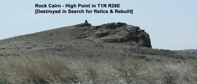
12-Rock
Cairn
|
|
No trek can be complete without a nearby rock cairn. The
story goes that one of the early homesteader families had some eager
children, who wondered if there were Indian remains buried under the rock
formation. Thus they tore it down, finding nothing they left the stones
where they discarded them. The parents, however, had different ideals –
and they made the boys rebuild the cairn ‘just as they found it.’
The cairn is about six-feet tall, and constructed
from the surface rock. Some thought that it might have been an earlier
sheepherder monument; but no other details exist.
|