 -
- 
|
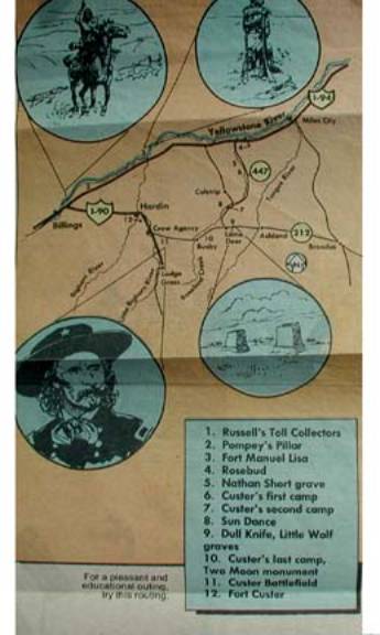
Part 1 –
General Custer’s Southward Trip from the Yellowstone River
|
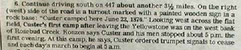
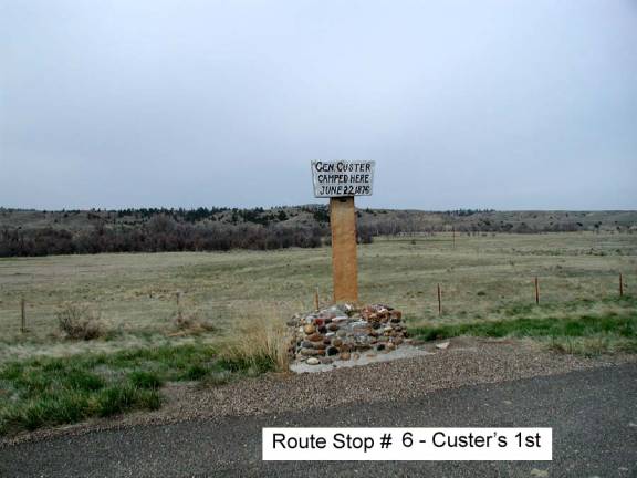
|
|||||
|
Departing from
|
|
|||||
|
|
|
|
||||
|
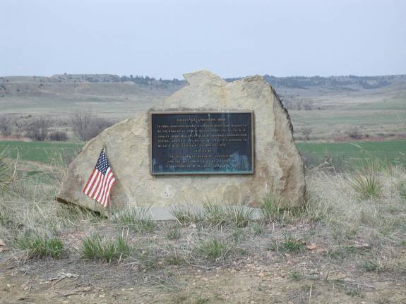
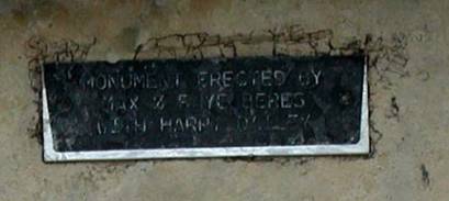
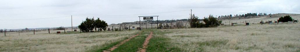
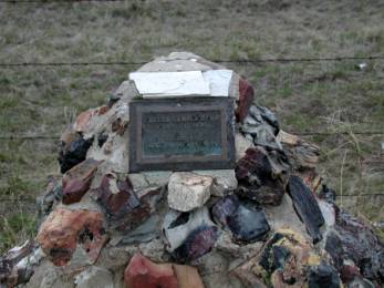
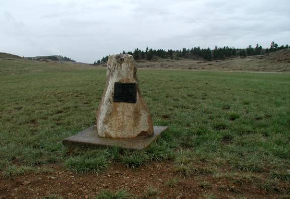
The placard, located directly below the sign, reads: “MONUMENT ERECTED BY MAX & FAYE BERES WITH HARPY DALLEY” The vertical post is a stone slab. Many persons have tried to carve their names, but the stone is very dense, so the writing is barely visible. |
|
|
||||
|
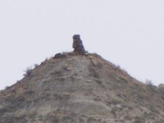
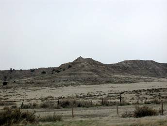
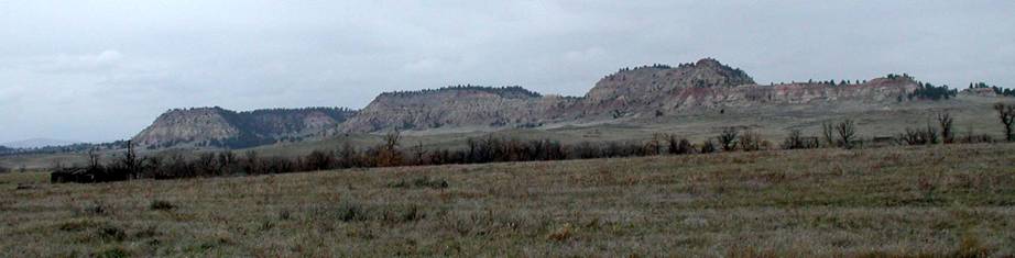
Note: 447 joins with 39 before reaching this site, which is about 40 miles distant. The route to stop 7 is on 39. Enroute, there are two rock cairns and a small 4-post corral mounted on the top of two small hills about ½-mile east of HWY 447. The first is about 10 miles south of the freeway; the second is about 20 miles (and located by a farm house.)
Between these two
|
|
|
|||||
|
|
|
||||||
|
|
|
|
|||||
|
|
|
|
|||||
|
Note: Additional directions not provided. |
|
|
||||
|
Part 2 – General Crook’s – “Battle
of the Rosebud” (Travel & Hiking)[1] |
|
|||||
|
After passing through Lame Deer travel west on
212 through Busby and turn south on paved road Highway 314 about ½-mile west
of Rosebud Creek |
|
|||||
|
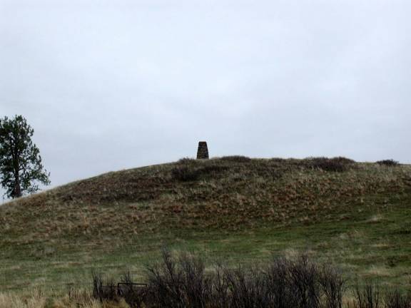
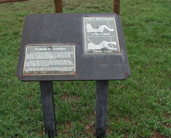
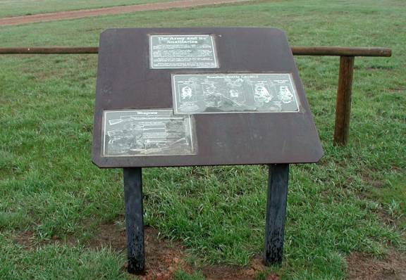
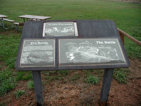
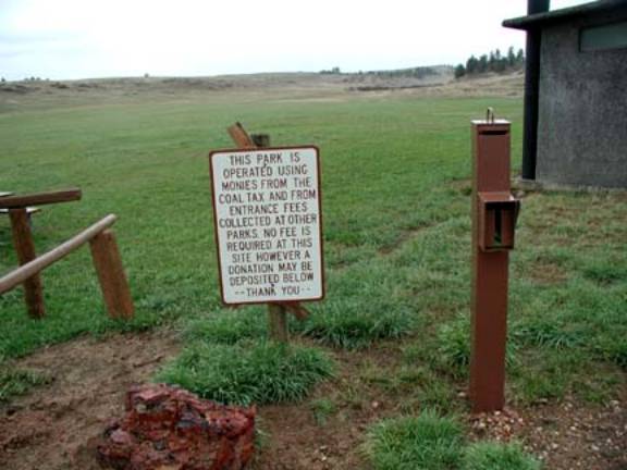
Look to the southwest, and on a small hilltop you will see a rock cairn entry marker. The site is on private property approximately ¼-mile to the west, but access is granted. At the site you will (or should) find a container containing a descriptive brochure of the site and event locator. There are 19 points of battle interest; starting at 8:30 am on June 17, 1876 and continuing through to the end some six hours later. The three battle maps following and created by the Combined Arms Research Library are provided to assist in your orientation of the site. See below for addresses. Signs are posted that direct you to the site. You are cautioned to stay on the road. Additionally, another point of interest is noted: the Slim Kobold Buffalo Jump, a short distance to the south of the site. This rocky cliff appears to be one of the oldest in the state. Prehistoric Indians ran the animals off the cliff.
|
|
|||||
|
|
|
|
||||
|
|
|
|
||||
|
|
|
|
||||
|
|
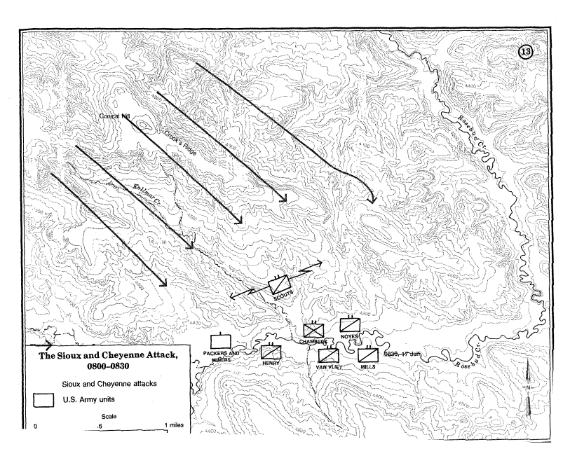
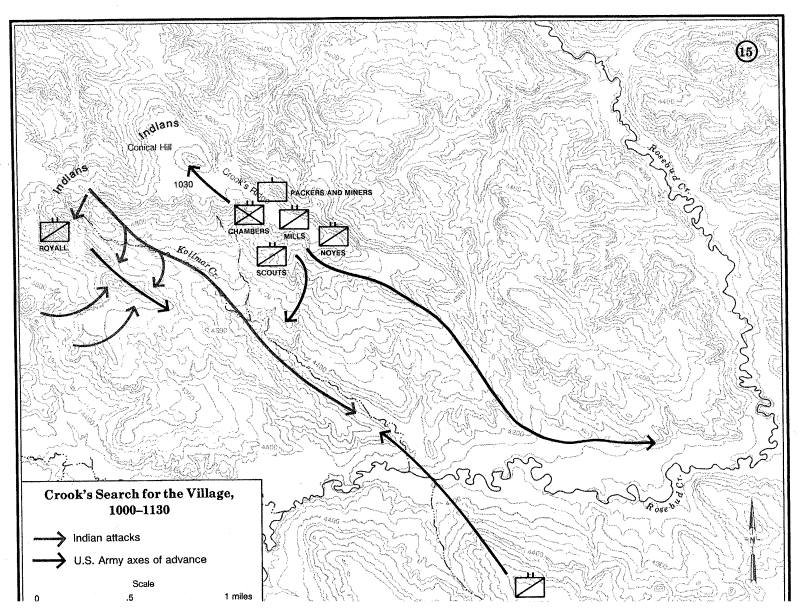
From: http://www-cgsc.army.mil/carl/ On 17 June, Crook's column roused itself at 0300 and set out at 0600, marching northward along the south fork of Rosebud Creek. The holiday atmosphere that prevailed since the arrival of the Indian scouts on 15 June was suddenly absent. The Crow and Shoshone scouts were particularly apprehensive. Although the column had not yet encountered any sign of Indians, the scouts seemed to sense their presence. The soldiers, on their part, were apparently fatigued from the previous day's 35-mile march and their early morning reveille, particularly the mule-riding infantry. At 0800, Crook stopped to rest his men and animals, Although he was deep in hostile territory, Crook made no special dispositions for defense. His troops merely halted in their marching order. The battalions of Captains Anson Mills and Henry E. Noyes led the column, followed by Captain Frederick Van Vliet's battalion and Major Alexander Chambers' battalion of mule-borne foot soldiers, Captain Guy V. Henry's battalion and a provisional company of civilian miners and packers brought up the rear. Fortunately the Crow and Shoshone scouts remained
alert while the soldiers rested. Several minutes later, the soldiers in camp
could hear the sound of intermittent gunfire coming from the bluffs to the
north. At first, they dismissed the noise as nothing more than the scouts
taking potshots at buffalo. As the intensity of fire increased, a scout
rushed into the camp shouting, "Lakota, Lakota!" The |
|
||||
|
|
In response to the Indian attack, Crook directed his forces to seize the high ground north and south of the Rosebud. He ordered Captain Van Vliet, with C and G Companies, 3d Cavalry, to occupy the high bluffs to the south. Van Vliet scaled the hill just in time to drive off a small band of Sioux approaching from the east. In the north, the commands of Major Chambers (D and F Companies, 4th Infantry, and C, G, and H Companies, 9th Infantry) and Captain Noyes (B, E, and I Companies, 2d Cavalry) formed a dismounted skirmish line and advanced toward the Sioux, Their progress war, slow, however, because of flanking fire from Indians occupying the high ground to the northeast. To accelerate the advance, Crook ordered Captain Mills, commanding six companies (A, B, E, I, L, and M) of the 3d Cavalry, to charge this group of hostiles. Mills' mounted charge unnerved the Indians and forced them to withdraw northwest along the ridgeline, not stopping until they reached the next crest (now called Crook's Ridge). Here, Mills quickly re-formed three of his mounted companies (A, E, and M) and led his troopers in another charge, driving the Indians northwest again to the next hill (Conical Hill). Mills was preparing to drive the Indians from Conical Hill when he received orders from Crook to cease his advance and assume a defensive posture. Chambers and Noyes now led their forces forward in support and, within minutes, joined Mills on top of the ridge. The bulk of Crooks command, now joined by the packers and miners, occupied Crook's Ridge. Establishing his headquarters there at approximately 0930, Crook contemplated his next move. Meanwhile, at the west end of the field, Lieutenant
Colonel William Royall, Crook's second in command, pursued the Indians
attacking the rear of Crook's camp. Leading Captain Henry's battalion (D, F,
and L Companies, 3d Cavalry) and two companies (B and I) borrowed from Mills'
command, Royall advanced rapidly along the ridgeline to the northwest,
finally halting his advance near the head of Kollmar Creek. Royall's
detachment was now a mile from the main body and in some danger of being cut
off and destroyed. Sensing this vulnerability and exploiting their superb
mobility, the Sioux and |
|
||||
|
|
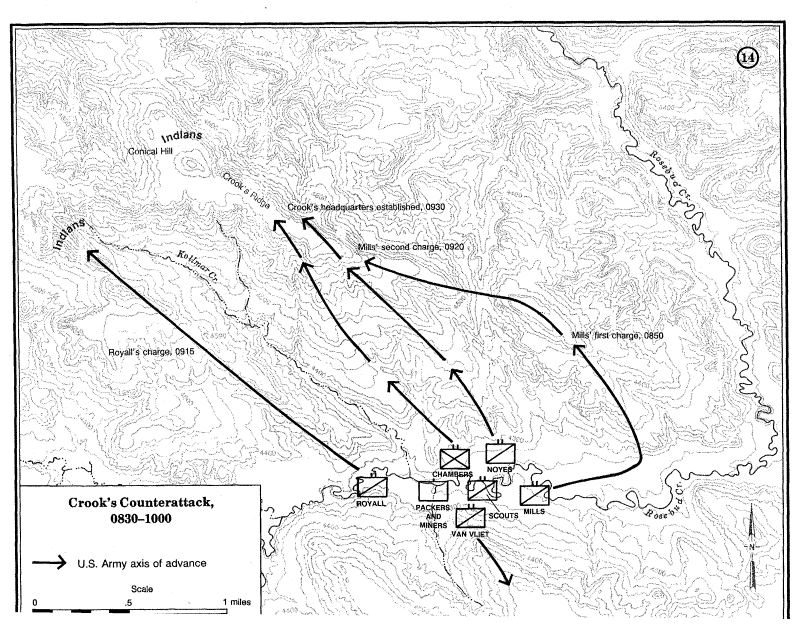
Crook's initial charges secured key terrain but did
little to damage the Indian force. The bluecoats' assaults invariably
scattered the Indian defenders but did not keep them away. After falling
back, the Sioux and Casting about for a way to defeat his elusive opponent, Crook returned to his original campaign plan. Since the Indians had been fighting him with unprecedented tenacity, it suggested that they might be fighting to defend their families in a nearby village. Thus, Crook decided to advance down the Rosebud valley where he hoped to find the hostile encampment and force the enemy to stand and fight. At about 1030, Crook ordered Mills and Noyes to withdraw their commands from the high ground and follow the Rosebud north. To replace the cavalry, Crook recalled Van Vliet's battalion from the south side of the Rosebud. One mile to the west, Royall's situation continued
to deteriorate. Royall tried to withdraw across Kollmar Creek but found the
Indians' fire too heavy. Instead, he withdrew southeast along the ridgeline.
In an attempt to further isolate and overwhelm Royall's force, a large group
of Indians charged boldly down the Troubled by fire from Indians on Conical
Hill, Crook ordered Chambers' infantry to drive the Sioux away. The foot
soldiers promptly forced an enemy withdrawal-but to little avail. It was a repetition
of the same old pattern; the soldiers could drive the Sioux away at will, but
they could not fix and destroy them. Crook could only wait and hope that
Mills' advance down the valley would be successful. |
|
||||
|
Combined Arms Research Library They have a link at: http://www-cgsc.army.mil/carl/ We are grateful for their detailed presentation. |
|
|||||
|
|
|
|||||
|
|
|
|||||
|
|
|
|||||
|
[1]
The
|
||||||

 This
road passes to the east of the battle site, and continues on to
This
road passes to the east of the battle site, and continues on to 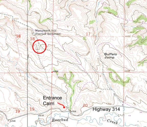
© 2014 MTGenWeb