INTRODUCTION
The goal of this project is to present genealogical and historical details about Jefferson County, Montana, and its people. This website is part of the MTGenWeb Project and USGenWeb Project, a group of volunteers dedicated to providing free data for researchers. My name is Donna Sims Conner and I am pleased to be the coordinator for Jefferson County.
History
Jefferson County was created on 16 January 1864, by the first territorial assembly of Idaho. It became a part of Montana Territory on 26 May 1864, and was one of the nine original counties. The first county seat was Jefferson City, succeeded by Radersburg in 1869, and Boulder in 1886. The county was named for Thomas Jefferson, third President of the United States. He was responsible for the Louisiana Purchase, which included most of the territory in which Montana was situated.
The first inhabitants in the area were the Blackfeet and Flathead Indians. As early as 1805, the Lewis and Clark Expedition passed through the region. The following decades saw the arrival of fur traders and trappers, followed by Jesuit missionaries. Some of the area's earliest communities were established as a result of gold and silver mining. These communities included Basin, Clancy, Corbin, Elkhorn, Gregory, Jefferson City and Wilkes. Farming and stock raising began along with the establishment of mining camps. The fertile farm lands around Boulder and Whitehall contributed to the growth of the agricultural industry in the late 19th century.
Source: Abstract from the document, "A Short History of Jefferson County, Montana," in the Laserfiche Records; located on the website, Jefferson County, Montana, Office of the Clerk and Recorder, accessed 18 May 2022.
Geography
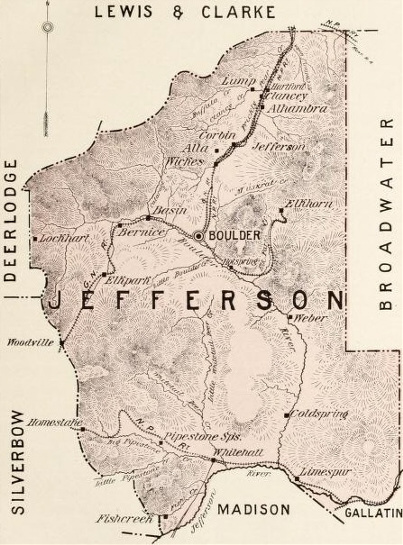 Jefferson County is bounded on the north by Lewis and Clark County and Powell County, on the west by Deer Lodge County and Silver Bow County, on the south by Madison County and Gallatin County, and on the east by Broadwater County. It has an area of 5,000 square miles including an abundance of waterways. The Missouri River runs through the eastern portion of the county, and the Jefferson River is located in the southern region. Many streams rise and flow through the county and empty into these rivers. Principal among them are Boulder Creek, Prickly Pear Creek, Clarke's Creek, Indian Creek, Whitetail Deer Creek, Pipestone Creek and Fish Creek. Most of the streams named above flow through valleys measuring from 5 to 6 miles in width and from 10 to 40 miles in length.
Jefferson County has its quota of mountains; the summit of the Rockies for about 60 miles in length, from north to south, forms its entire western boundary. The Crow and Bull Mountains are located in the southeast, with smaller ranges between them. The county is also home to three noted hot springs: the Boulder, within two and a half miles of the city; the Pipestone, on Pipestone Creek; and the Clancy, on Prickly Pear Creek.
Source: Abstract from the newspaper article, "Jefferson County," in The Holiday Miner, Butte, Montana, published on 1 January 1888; located on the website, Chronicling America (http://chroniclingamerica.loc.gov), accessed 18 May 2022. Map from the book, Society of Montana Pioneers, Volume I, edited by James U. Sanders, published in 1899; located on the website, Internet Archive (http://archive.org), accessed 27 May 2022.
Search
Affiliations

Recognition
We would like to recognize the contributions of Ellen Rae Thiel. For many years, she was the Jefferson County coordinator. We appreciate her hard work and dedication!