In the open range and ranch country,
post offices provided the principal means of communication to the
rest of the world for the cowboys and ranchers. Later on, during the
homesteading boom, the post office became the center of fledgling
towns. In most cases, these homestead communities did not survive,
but the place names survive locally.
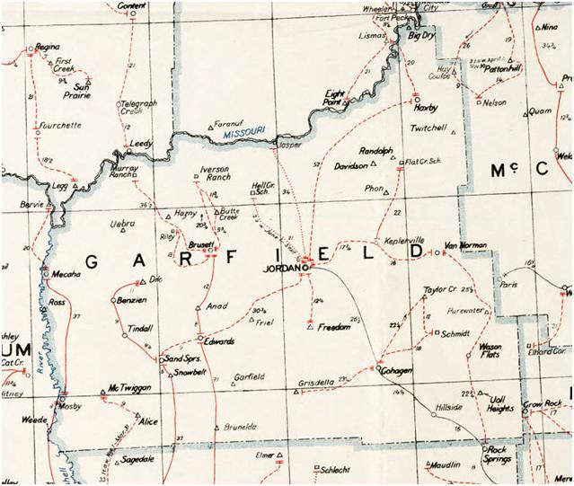
1937 Postal Road Map of Garfield County.
Alice - Post Office 1914-1934.
Allen
- Post Office 1914-1920.
Anad -
Post Office 1918-1930.
Belfast
- Post Office 1904-1905.
Benzien
- Post Office 1916-1943, on a fork of Lodgepole Creek.
Big
Dry - Big Dry Creek first mentioned in the Lewis and Clark Journal on
May 6, 1806. A Post Office named Big Dry existed 1911-1913.
Blackfoot
- a settlement on Seven Blackfoot Creek.
Bowmanville
- Post Office 1913-1916. Became Dilo Post Office.
Bruce
- Post Office 1913-1919.
Brunelda
- In the southern part of county. Brunella was a post Office
1914-1936.
Brusett
- Post Office established in 1916. Brusett is a community in
northwest Garfield County. The town is unincorporated but maintains a
Post Office. (ZIP 59318).
Butte
Creek - Post Office 1913-1936.
Dilo -
Post Office 1916-1935. Formerly called Bowmanville and Bright Star.
Located on Lodgepole Creek.
Chaldea
- Post Office 1915-1916.
Cohagen
- Post Office established 1905. Although Cohagen is an unincorporated
community in Southeast Garfield County, it continues to have a Post
Office (ZIP 59322).
East
Fork - Post Office 1915-1923.
Edwards
- Post Office 1913-1945, near Gumbo Flats and Sand Springs. Named for
James Edwards, a Cowboy from the open range days. Later he was a
state senator from Rosebud County.
Finger
Butte - Post Office 1921-1934.
Freedom
- Post Office 1914-1933.
Friel
- Post Office 1925-1929.
Garfield
- Post Office 1914-1923.
Grisdella
- Post Office 1927-1937.
Haxby
- Located near the head of Box Creek, near the Missouri River. Post
Office 1915-1959. This place was near an important crossing of the
Missouri River for mail and supplies.
Hay
Coulee - Post Office 1915-1925. The site is now under Fort Peck Lake.
Hazny
- formerly named Trouble. Post Office 1918-1934.
Hillside
- Post Office 1914-1945 in southeastern Garfield County.
Jordan
- Located on Big Dry Creek, is the county seat of Garfield County.
Probably named for Arthur Jordan who settled there in 1896, and was
the first Postmaster.Post Office established in 1899 (ZIP is 59337).
Keplerville
- Post Office 1914-1945.
Kismet
- Post Office 1901-1909, at the mouth of the Musselshell River.
McTwiggin
- Post Office 1917-1935.
Mecaha
- Post Office 1915-1941.
Mosby
- An unincorporated community in southwest Garfield County, Mosby had
a post office from 1902 to 1983. Although closed in 1983, the
community maintains a Zip Code - as Mosby Rural Station. (ZIP 59058).
Norvella
- Post Office 1904-1907.
Phon -
Post office from 1915 to 1936, on Woody Creek.
Pure
Water - Post office 1917-1930.
Randolf
- Post Office 1914-1919.
Ross -
Post office 1906-1935. It is along the Musselshell River.
Round
Butte - A prominent butte in northeastern Garfield County. Post
office 1915.
Sand
Springs - An unincorporated community In southwestern Garfield
County, along highway 200. The post office was established in 1911
(ZIP 59077).
Sanford
- Post Office 1899. The name was later changed to Belfast.
Smokey
Butte - Post Office 1914-1920.
Snowbelt
- Post office 1913-1920.
Soda
Springs - So named because the Springs contained sodium. The N-N
ranch built a cabin in 1885 here, believed to be the first dwelling
in the Big Dry country.
Steve's
Fork - Post office 1917-1918.
Taylor
Creek - Post office 1922-1934.
Tindall
- Post office 1914-1937.
Trenton
- Post Office 1903-1905.
Twitchell
- Post office 1919-1921.
Uebra
- Post office 1919-1936, on Indian Creek.
Uoll
Heights - Located at the head of You All Creek. Post office
1916-1935.
Van
Norman - Located on Dry Creek, it was a post office from 1914 to
1963.
Place
names and dates extracted from: Names on the Faces of Montana,
by Roberta Carkeek Cheney, Copyright 1983, Mountain Press Publishing
Company (Third Printing 1987)